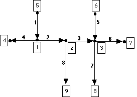
Lines are stored as arcs. Each arc starts and stops at a node. Because the arc starts and stops at a node, the arc has direction, defined by which node is the from node (FNODE) and which node is the to node (TONODE). Consider the following sketch of arc-node topology, and fill out the table that follows (nodes are indicated by boxed numbers, arcs by unboxed numbers).
ARC
|
From
Node
|
To
Node
|
| 1
|
5
|
1
|
| 2
|
||
| 3
|
||
| 4
|
||
| 5
|
||
| 6
|
||
| 7
|
||
| 8
|
Arcs form the boundaries of polygons. The topology of a polygon coverage contains both an ID# for each arc and the identification of the polygon bounded on the right (RPOLY) and left (LPOLY) of the arc. This topology is created when a coverage is cleaned or built (e.g., CLEAN <cover>, or BUILD <cover> in Workstation ArcInfo). Consider the following sketch of polygon-arc topology, and fill out the table that follows (polygons are indicated by boxed numbers, arcs by unboxed numbers).
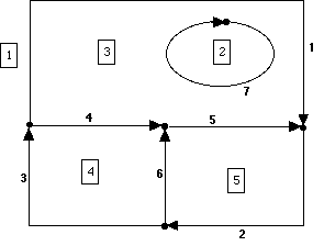
Also, consider arc ID#1. How does this arc turn two corners without have nodes at these corners?? __________________
POLY
|
#
of ARCS
|
ARCS
|
| 2
|
1
|
7
|
| 3
|
||
| 4
|
||
| 5
|
ARC
|
Left
POLY
|
Right
POLY
|
| 1
|
1
|
3
|
| 2
|
||
| 3
|
||
| 4
|
||
| 5
|
||
| 6
|
||
| 7
|
http://dusk.geo.orst.edu/arc/topology_ex.html