Axial Zone Imaged Based on Argo II Trackline Coverage - Calculations Based on Axial Lava Ages Forthcoming....
> In reality we had some gaps between our lines, and this is what I was trying
> to get at (the area of the gaps relative to the total axial zone area per
bin).
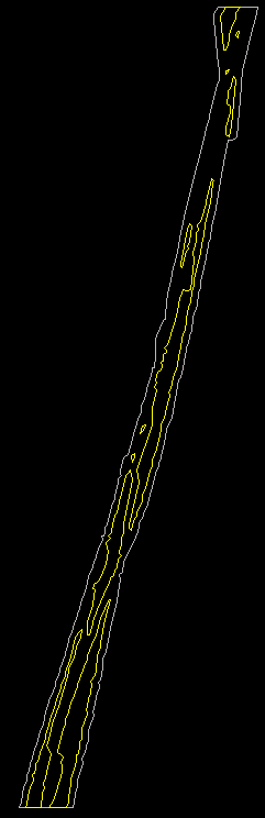
Yes, see the gif images below. The first
image (snap2021.gif) shows buffered tracks in the bin from 17 20' to 17 21'.
This is from ArcEdit. The yellow *outlines* the gaps in between the
buffered tracks that we did NOT image.
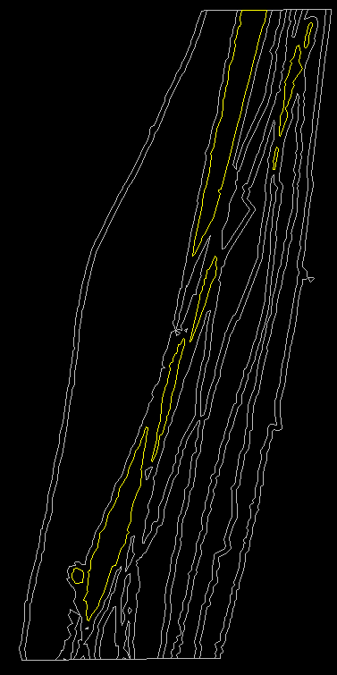
This second image shows a
similar situation for 17 24' to 17 25'. Some (not all) of the gaps
are outlined in yellow.
When Arc/INFO buffers, each new polygon created is flagged according to the type of area it represents. These flags are stored in an attribute called INSIDE. An INSIDE of 100 = Polygon(s) representing the buffer zone, whereas an INSIDE of 1 = Polygon(s) outside the buffer zone. Don't worry, Arc/INFO does not double count for areas overlapping in space - it dissolves arcs that cross and makes one area. At any rate, adding up the areas of the polygons that were flagged INSIDE = 1 gives us the areas of the gaps. To get the areas of the gaps relative to the total axial zone per bin wouldn't we just do:
axial area imaged / (axial area imaged + gaps in axial zone not imaged)
This gets us almost there except for the fact that a careful look at the tracklines in ArcView shows that from 17 22' - 17 26' our N-S trackline coverage extends across a zone ~300-700 m wide (to hammer the Spike of course), whereas most of the rest of our N-S tracks extend across a zone ~100-200 m wide. This doesn't necessarily mean that the axial zone is wider right at the Spike, but that we surveyed that area more intensely. So I took a crack at normalizing the axial area imaged #'s to match most of the survey where our N-S tracks spread ~100-200 m. Once again, the axis stuff excludes the first line where we were misled by DSL-120 and has the cross-axis (E-W) tracks cropped out. I did everything twice to double-check and here are the numbers - shake 'em or bake 'em! :-) ....
Lat     % Axial % Axial     Gap in      Axis Imaged     Axis & Off-Axis
Range   Zone    Zone       Coverage       sq km            sq km
        Imaged  Imaged      sq km
                (Normal)
15-16   67.22   18.73   0.01827293      0.03746944      0.10084913
16-17   54.40   54.00   0.09053014      0.10800331      0.14488528
17-18   63.28   29.60   0.03434533      0.05919528      0.07941533
18-19   67.30   48.13   0.04677313      0.09625427      0.12407049
19-20   57.74   48.97   0.07169012      0.09793433      0.11072579
20-21   65.39   48.61   0.05144755      0.09722271      0.11429322
21-22   52.17   52.74   0.09672941      0.10548781      0.13491658
22-23   32.39   54.75   0.22855634      0.10950491      0.12740967
23-24   32.51   74.05   0.30745795      0.14809319      0.17083012
24-25   27.02   140.41  0.7586354       0.28082033      0.30961728
25-26   36.68   129.51  0.44719951      0.25902779      0.35301469
26-27   57.53   76.72   0.11327095      0.15344209      0.23931063
27-28   59.12   86.66   0.11982662      0.1733137       0.18607553
28-29   66.77   105.44  0.10494127      0.21088731      0.23588539
29-30   67.20   65.31   0.06373941      0.13061589      0.15404359
30-31   51.04   58.97   0.11314374      0.11793489      0.13412114
31-32   34.32   60.35   0.23104607      0.12070435      0.13737672
32-33   55.69   68.00   0.10823257      0.13600947      0.16071625
33-34   54.82   60.24   0.0993111       0.12047759      0.13625744
34-35   47.50   68.22   0.15081526      0.13644249      0.15586993
35-36   69.71   86.06   0.07478042      0.17211391      0.24507231
36-37   56.29   90.41   0.14038662      0.18082202      0.19852866
37-38   61.05   96.67   0.12334976      0.19334782      0.22758733
38-39   58.50   68.14   0.09668797      0.13628146      0.1565233
39-40   56.17   59.78   0.09329907      0.11955956      0.14350097
> It seems like we could make a map (in GIS) of our actual (buffered)
> line coverage, and compare this in some way within GIS to the total area of
> the axial zone of each bin to calculate the geographic area that was not
> imaged in each bin, but I don't how this would be done. Let me know if you do.
I could probably make some representative maps from certain bins if these are needed for publications later. And if these calcs do indeed prove useful then I will do the same for the Hump area. Wasn't able to get to it because it takes a while to make the 1-minute latitudinal boxes that are used for cookie cutters.
Take it easy,
Dawn