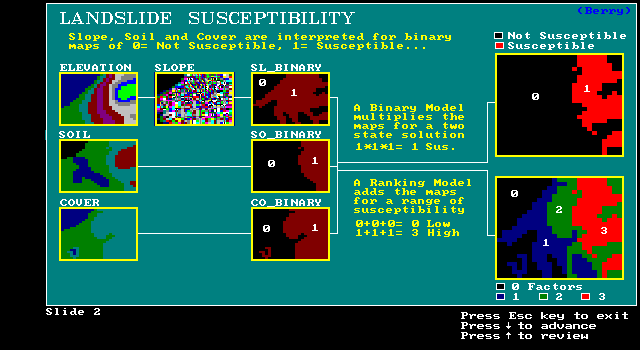
multiplicative: cells must meet all 3 criteria
GIS is only as good the expression of its data
we will compare several GIS models to illustrate different modeling approaches
we will compare varying levels of results from these models
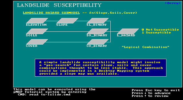
SL - terrain steepness (high slope/low slope)
SO - soil type (unstable/stable)
CO - vegetation cover (bare/abundant)
BINARY model: codes cells 1 for susceptible, 0 for unsusceptible
multiplicative: cells must meet all 3 criteria
BINARY model: multiplies maps for Y/N solution
RANKING model: adds maps for a range of solutions
RATING model: averages maps for an even greater range of solutions
scale of 1 to 9 (most) for each condition
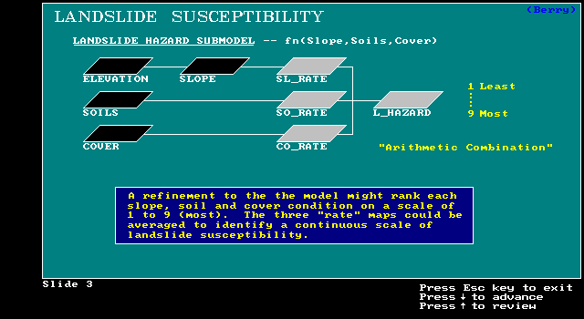
RATING model: for example one cell might be 9 in SL layer, 3 in SO, 3 in CO
(9 + 3 + 3) / 3 = 5 or moderate susc.
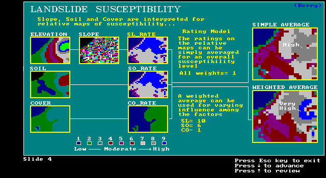
suppose SL is considered to be 5 times more important than SO or CO?
so one cell might be:
-- 9 * 5 in SL layer, 3 in SO, 3 in CO((9*5)+ 3 + 3) / 3 = 17
type of models (cartographic) - constant
logic of models or conceptual fabric of process - different
-- continuum of responses/answers
-- most mathematical/mapematical??
-- foothold to extend model even further from critical to contributing factors
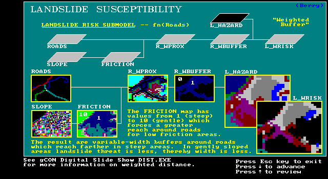
Extension of Landslide Model to Risk:
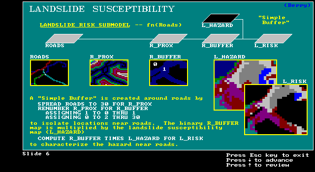
Consider proximity to features that we may really care about, such as roads
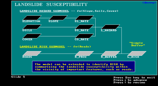
Create Road buffer by spreading road cells to 30 for R_PROX, renumber cells in R_PROX 1 and 0 to form R_BUF, multiply R_BUF by L_HAZ to get L_RISK
Further Extension:
variable width buffers as a function of SLOPE
buffer widens in steep areas
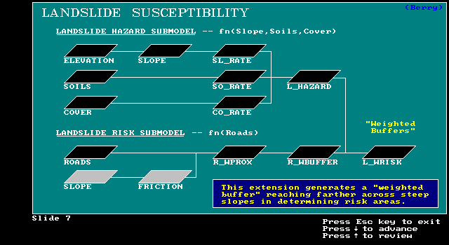
Renumber Slopes to get Friction map
Friction map guides varible width proximity and binary variable width buffer
R_WBUFF * L_HAZ = L_WRISK
-- disturbance: construction areas, gophers?
-- environmental: storm frequency, rainfall patterns
-- seasonal: freezing and thawing cycles in spring
-- historical: past earthquake events
-- weight roads based on traffic volume, emergency routes, etc.
-- buildings: commercial, residential, etc.
-- economic value of threatened features, potential resource loss
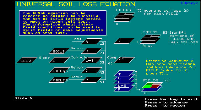
Another option: review literature for existing mathematical model and use it!
"Mapematical" version of the Revised Universal Soil Loss Equation
(RUSLE)
Expected soil loss per acre from 6 factors
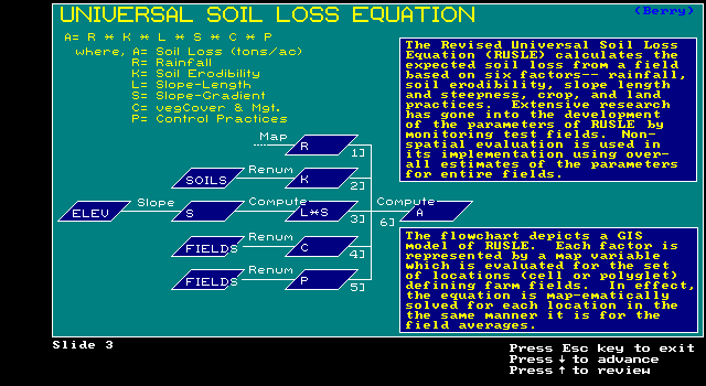
RUSLE evaluated in 2 ways:
Aggregated - executes model for whole
region
(e.g., entire watershed) & applies it to one parcel
Disaggregated - break region into subregion & executes model on
subregions
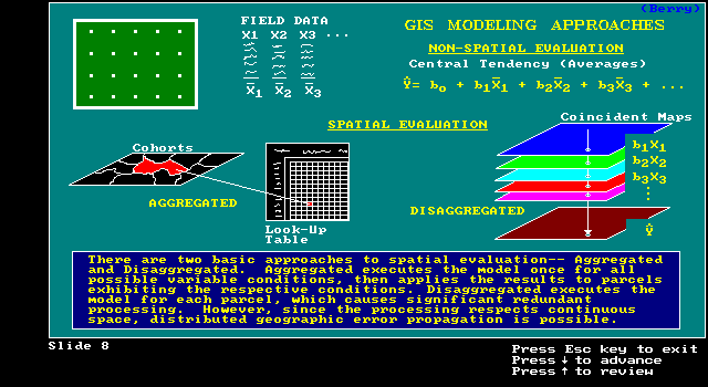
Disaggregated Approach: Soil loss for each subunit
scale of elevation data may be too small for accurate slope map
is disaggregated approach still non-spatial?
-- assume avg. soil loss value is uniformly distributed for each subunit?