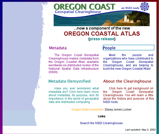
Certainly an important aspect of the OCA is how it contributes to the broader network of coastal resource managers across the nation. The national spatial data infrastructure (NSDI; and within that the Coastal NSDI to meet the needs of the coastal and marine communities), with its timely focus on rethinking the methods of spatial data delivery to users, represents a welcome change from the centralist period in geographic information management when federal agencies dominated decisions and data resources (Wright et al., 2000). Empowerment and efficiency at regional scales all the way up to the NSDI results from local groups taking up the challenge of data dissemination. For the state of Oregon, an initial partnership of Oregon State University (OSU) with the Pacific Northwest Coastal Ecosystems Regional Study (PNCERS, funded by the Coastal Ocean Program of NOAA and the Oregon Coastal Management Program of Oregon's Department of Land Conservation and Development), the Tillamook Coastal Watershed Resource Center (TCWRC, formerly one of 28 National Estuary Projects established nationwide by the EPA), Ecotrust (one of the largest non-profit environmental conservation organizations in the Pacific Northwest and a leader in public access GIS), and the State Service Center for Geographic Information Systems led to the development in 1997 of the Oregon Coast Geospatial Clearinghouse (OCGC) (Figure 1). The OCGC still functions as an NSDI node but now functions in the background to the OCA, incorporating metadata records for the hundreds of data sets that are part of that new effort, and broadening the reach of the OCA in the process.
Under "Search", the ability to find data is enabled both via traditional query forms (e.g. for keyword, scale, source, etc.) and by "area of interest" selection via a map interface. Both geospatial data (e.g. Arcview shapefiles) and non-geospatial information (e.g. bibliography entries, online documents) can be returned from a single search. All GIS data returned is documented to the FGDC metadata standard and all metadata records co-reside in an NSDI searchable node making them retrievable to any user with an NSDI client.
The "Learn" section provides access to background information on both "Coastal Systems" such as estuaries, sandy shores, rocky shores, and ocean areas, and "Coastal Topics" such as hazards, public access, fisheries, processes, etc. The format allows for descriptive narrative, static images, and animations, and cross-links whenever possible with relevant datasets available in the archives. Similarly, the "Tools" section of the web site will provide specific interactive tools for utilizing archive data to solve directed topic-based questions (e.g. will a certain property be inundated in a 20-year storm during an El Nino year?). Each tool will be cross-linked with a topic-based help tutorial that will also be accessible from the "Learn" section.
Features available under the "Map" section include those typical of many web-mapping applications: Pan, Zoom In, Zoom Out, and Query are all available in a compact and simplified layout with pop-up advice as to appropriate uses. Users can browse preformatted datasets in the form of raster backdrops with vector overlays, for the entire Oregon coastal zone including the territorial sea. In addition, archive datasets identified by users may be interactively added to the base map to provide maps of personalized interest. Users may also dynamically switch between HTML and Java Applet-based interfaces to accommodate the widest audience of browsers and platforms. Once a custom map has been created, output to a printer-friendly format (e.g. PDF) is possible.
The goal of the OCA is to address the needs of the coastal resource manager or coastal planner within the state of Oregon. End-user training and direct technical assistance are being incorporated into the development of the atlas, (via "mailto" links that reach project partners, with responses within 24 hours, as well as self-help pages), as are back-end system maintenance tools to ensure system longevity. In this way we seek to improve universal participation in coastal decision-making among communities by extending infrastructure to public offices that would otherwise face difficulties accessing these services and resources. But our connection to the NSDI via the OCGC broadens our reach to the national scale. We cannot hope to support public offices in other states of course, but the design and architecture of the atlas, as well as the provision of metadata and data, may be of help to other state ocean/coastal management programs. We are currently seeking FGDC funding to support our next planned activity in support of the NSDI: the addition of a searchable OpenGIS Consortium Web Map and Web Feature Service to the OCGC, as well as to servers running the main OCA site (with MapServer 3.6) and auxiliary servers at Ecotrust and Oregon State University running ArcIMS 4. Beyond that we hope to participate in Geospatial One-Stop via a liaison with the National Map, or by virtue of our NSF funding as part of the Digital Government initiative.
We are indebted to our terrific team of student workers for programming support, the writing of metadata records, and general research and database assistance. These include undergraduate intern Mike Tavakoli-Shiraji, graduate students Ken Crouse, Chris Zanger, and Danielle Pattison, and metadata maniacs Amythyst O'Brien, Christina Ryan, Anthea Fallen-Bailey, Jenny Allen, Jessica Adine, and Ryan Field. Thanks also to John Marra of the NOAA Pacific Services Center and David Revell of Oregon Surfrider for valuable research collaborations and tool-building during the early phases of this project. We very much appreciate the guidance and support of Bob Bailey of the Oregon Ocean-Coastal Management Program. The Oregon Coastal Atlas is currently funded by National Science Foundation (NSF) grant EIA-001359, as well as by supplemental grants from the NOAA Coastal Services Center and the Federal Geographic Data Committee.
Isite Metadata Server 2.07
http://clearinghouse4.fgdc.gov/ftp/, Accessed 20 June 2003.
NOAA Coastal Services Center, 2003, Coastal NSDI, http://www.csc.noaa.gov/themes/nsdi/, Accessed 20 June 2003.
NOAA CSC Metadata Collector Extension for ArcView 3.x
http://www.csc.noaa.gov/metadata/text/download.html, Accessed 20 June 2003.
Wright, D., Duvall, G., and Ward, B., 2000. Metadata matters: A national geospatial clearinghouse for the Oregon Coast, Proceedings of The Coastal Society 17th International Conference, Portland, Oregon.
Tanya Haddad
Paul Klarin
Michele Dailey
Randy Dana
Metadata Within the OCA
Metadata creation and access for the OCA has followed a very standard approach as facilitated by the Federal Geographic Data Committee (FGDC). FGDC-compliant metadata for all OCA data sets and remotely-sensed images has been created with the Metadata Collector Tool for ArcView 3.x developed by the NOAA Coastal Services Center (www.csc.noaa.gov/metadata/text/metatools.html). The tool can create metadata for any data type supported by ArcView, including ArcInfo coverages, ArcView shapefiles, and any supported raster image formats. FGDC parsing software (mp) was then used to ensure correct format before final indexing and loading into the clearinghouse, and to create both HTML and SGML versions of the metadata.
Next, the metadata were indexed for clearinghouse searches using specialized software provided by the FGDC (Isite v. 2.07i for clearinghouse node services) running on a Sun Blade 100. Isite software creates a server process that can respond to queries against full-text, spatial terms, temporal terms, and text fields within metadata documents. All metadata records (we currently have over 700 of them) are accessible via a search on the OCA (Figure 2; the server for which resides at the Oregon Ocean-Coastal Management Program in Portland, OR), which has mirror copies of all the metadata records, as well as the actual data sets (Figure 2). Both the OCGC and the OCA web sites include helpful online tutorials about metadata and clearinghouses.
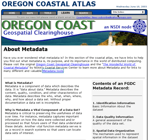
Figure 2. Portion of the "Learn" section of the Oregon Coastal Atlas that informs users about metadata and leads them further to the Oregon Coast Geospatial Clearinghouse, an NSDI node. Note the navigation tabs at top, leading users to the major "Search", "Learn", "Tools" and "Map" sections of the web site.
General Functionality of the OCA
As mentioned above, the OCGC functions in the background to the OCA, where users should actually start their search for data. The OCA consists of four main functional areas: "Search", "Learn", "Tools", and "Map" (Figure 2). The intention is for users to be able to look for and find data pertaining to a particular enquiry, to understand the original context of the data, and to be able to put selected data to use via online tools in order to help solve a question. Major content is always made accessible through multiple paths to accommodate different types of audiences/searchers. All functions occur via a unified and highly cross-linked interface that helps provide an intuitive workflow and seamless user experience. Conclusion
Acknowledgments
References and Links
Dawn J. Wright
Professor
Department of Geosciences
104 Wilkinson Hall
Oregon State University
Corvallis, OR 97331-5506
Telephone: 541-737-1229
Fax: 541-737-1200
Email: dawn@dusk.geo.orst.edu
Oregon Ocean-Coastal Management Program
800 NE Oregon St # 18, Suite 1145
Portland, OR 97232
Telephone: 503-731-4065, ext. 30
Email: tanya.haddad@state.or.us
Oregon Ocean-Coastal Management Program
635 Capitol St NE, Suite 150
Salem, OR 97301-2540
Telephone: 503-373-0500, ext. 249
Email: paul.klarin@state.or.us
Ecotrust
Jean Vollum Natural Capital Center, Suite 200
721 NW Ninth Avenue
Portland, OR 97209
Telephone: 503-227-6225
Email: michele@ecotrust.org
Oregon Ocean-Coastal Management Program
800 NE Oregon St # 18, Suite 1145
Portland, OR 97232
Telephone: 503-731-4065, ext. 31
Email: tanya.haddad@state.or.us