
[ home port | lectures | labs | discussion | announcements | surf | email prof. ]
 Lab 5
Lab 5Things to Get Out of This Lab:
Materials: Invitation to Oceanography textbook
Introduction
When the winds blow over the oceans, they set the surface waters in motion, driving the large-scale currents in a nearly constant pattern. These currents flow more in response to the average circulation patterns in the atmosphere than to daily changes in the weather. However, the major currents do shift slightly in response to long-term seasonal changes in the winds. These major surface currents are often called the "rivers of the sea." Although, they have no banks to contain them they maintain their average course with remarkable consistency. For example, here is how Matthew Fontaine Maury describes the Gulf Stream in his landmark book, The Physical Geography of the Sea, published in 1855:
"There is a river in the ocean. In the severest droughts it never fails, and in the mightiest floods it never overflows. Its bank and its bottom are of cold water, while its current is of warm. The Gulf of Mexico is its fountain, and its mouth is in the Arctic Seas. . . . There is in the world no other such majestic flow of waters. Its current is more rapid than the Mississippi or the Amazon."
The density of water also plays a crucial role in circulation. Processes that increase the density of water at the surface eventually cause a vertical, top-to-bottom exchange of water throughout the oceans. Because density is normally controlled by changes in temperature and salinity, this kind of circulation is known as thermohaline circulation. Thermohaline and wind-driven circulation are closely related. In fact the connections are so close concerning the formation of water parcels, upwelling and downwelling, and convergence and divergence, that it is sometimes difficult to assign a priority of importance to one process over another. Let's take a look at each in turn.
Thermohaline Circulation
The table below gives density in g/cm3 for various temperature and salinity readings.
Temp. 33o/oo 34o/oo 35o/oo
0 1.02652 1.02732 1.02813
1 1.02646 1.02726 1.02807
2 1.02640 1.02719 1.02799
3 1.02631 1.02711 1.02791
4 1.02622 1.02701 1.02781
5 1.02612 1.02691 1.02770
6 1.02600 1.02679 1.02757
7 1.02587 1.02665 1.02744
8 1.02573 1.02651 1.02729
9 1.02558 1.02636 1.02714
10 1.02541 1.02619 1.02697
11 1.02524 1.02602 1.02679
12 1.02506 1.02583 1.02661
13 1.02487 1.02564 1.02641
14 1.02467 1.02543 1.02621
15 1.02445 1.02522 1.02599
16 1.02423 1.02500 1.02577
17 1.02400 1.02477 1.02553
18 1.02376 1.02453 1.02529
19 1.02352 1.02428 1.02504
20 1.02326 1.02402 1.02478
21 1.02300 1.02375 1.02451
22 1.02272 1.02348 1.02424
23 1.02244 1.02320 1.02395
24 1.02215 1.02291 1.02366
25 1.02186 1.02261 1.02336
Data courtesy of Roger Hart, Hatfield Marine Science Center and
Oregon Coast Community College.
Fun Facts:
(1) After examining the table of data above, what are the temperature and salinity of the densest water?
(2) What are the temperature and salinity of the least dense water?
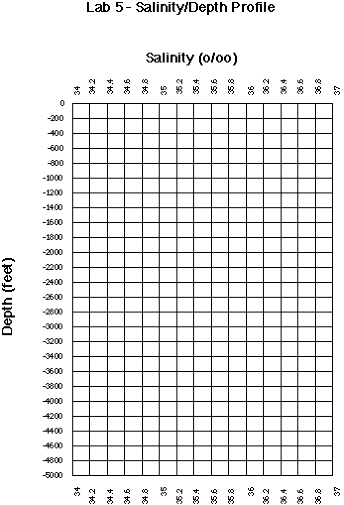
Here are some more data for you below. Please use it to plot two profiles of salinity versus depth on the grid provided here (note that depths are in feet not meters).
Depth Sal(1) Sal(2)
100 36.1 34.6
200 35.8 34. 6
400 35.5 34.6
600 35.0 34.7
800 34.9 34.8
1000 34.8 34.8
2000 34.7 34.7
3000 34.6 34.6
4000 34.6 34.6
(3) A halocline is a water layer with a large change in salinity with depth. Label the halocline on your profiles. Do you think the data for these profiles were collected in the tropics or in the polar regions? Why?
Refer to the figure below for the next 2 questions on thermohaline circulation. In the figure, the lightly shaded portion of the circulation band refers to warm, shallow currents, and the dark portion to cold, salty deep currents.
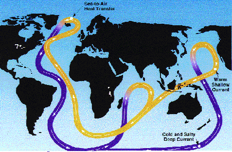
Figure courtesy of Roger Hart, Hatfield Marine Science Center and
Oregon Coast Community College.
(4) Define the word "thermohaline" (HINT: what factors drive ocean circulation of this type?).
(5) At what level in the water column do you think the warm, shallow thermohaline circulation is occurring: at the surface or at depth? Why? How about the cold salty thermohaline circulation?
Wind-driven Circulation
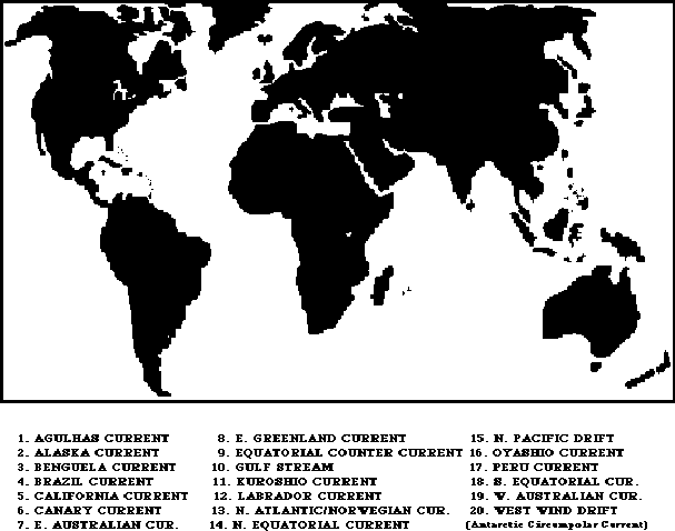
(6) On the map provided here, sketch the location and direction of flow for the following currents :
1 - Agulhas Current
2 - Alaska Current
3 - Benguela Current
4 - Brazil Current
5 - California Current
6 - Canary Current
7 - E. Australian Current
8 - E. Greenland Current
9 - Equatorial Counter Current
10 - Gulf Stream
11 - Kuroshio Current
12 - Labrador Current
13 - N. Atlantic/Norwegian Current
14 - N. Equatorial Current
15 - N. Pacific Drift
16 - Oyashio Current
17 - Peru (or Humboldt) Current
18 - S. Equatorial Current
19 - W. Australian Current
20 - West Wind Drift (or Antarctic Circumpolar Current)
(7) By inspection of the map for Question (6), give the relative temperature and speed of the following currents (i.e., describe each of them as either warm or cold, and fast or slow): Peru
Kuroshio
California
Gulf Stream
Agulhas
Canary
Guess what? Although the Antarctic Circumpolar Current (or West Wind Drift) is a very cold current because of it chilly locale, it is relatively FAST!
Last update: March 14, 1999
http://dusk.geo.orst.edu/oceans/lab5.html
Dawn Wright & Bob Duncan © 1999