
[ home port | lectures | labs | discussion | announcements | surf | email prof. ]
 Lab 7
Lab 7Things to Get Out of This Lab:
Materials: Graph paper.
Introduction
Longshore currents are maintained by the wave energy
component travelling parallel to the shoreline,
which causes part of the water mass to be transported
along the shoreline as well. The figure above shows that
waves approaching from the right generate a longshore
current that runs to the left. This is because there is a
component of wave velocity to the left. If breakers are
approaching perpendicular to the shoreline,
longshore currents will not form because there is
no horizontal component of wave energy parallel to the
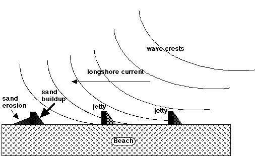
shoreline. Longshore transport of sand is caused by
the longshore current in combination with the stirring up
of sand by wave action. The figure below shows how sand piles up
behind obstructions in the longshore current. These
obstructions interrupt the "downstream" flow of
sand in the direction of the longshore current. Some harbors need to be dredged on a regular basis to
remove sand caught behind jetties, sand that would
normally be carried down the beach if not for the
existence of these man-made obstructions. If you have visited an Oregon beach year-round you
may have noticed that the amount of sand and the shape of
beach change as the seasons do. Sand appears to disappear
in the winter, sometimes leaving the beach quite rocky,
and then reappears during the summer. You may also have
noticed that the width of the beach varies depending on
its location. Much of the action at the beach takes place
underwater, to a depth of about 10 m. Daily wave action
moves sand up and down the beach. Seasonally, sand is
moved onshore and offshore. The wide Oregon beaches that
most of us think about and visit occur during the summer.
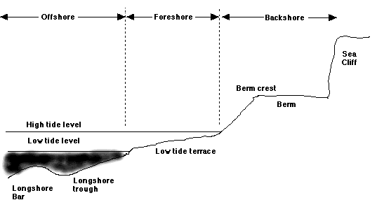
The ideal summer beach has a gradual, smooth slope. The
portion of the beach that is fairly flat and mostly dry is
called the berm. At high tide, material may be
deposited on top of the berm. During the storms of late
fall the summer slope (berm) erodes and sand is
transported offshore, perhaps forming a longshore bar. The
winter beach has a narrower berm. The reason for this
difference is the wave action. The large waves of winter
erode the berm; the small waves of summer rebuild it.
Actually, sand does not disappear during winter, but is
stored offshore in the longshore bar. The figure below
shows the major features of a beach profile. Coastal geologists normally do beach profile
measurements during the lowest daytime tide of a tidal
cycle, or about once every two weeks. Lab 8
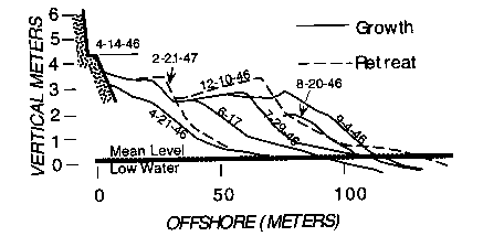
Activities The figure
below is from a long term study of sand movement at
beach near Carmel, California. It shows the progressive
growth of the berm from the dates 4/14/46 to 9/4/46, and
then its retreat on 12/10/46 and again on 4/21/47. Each
line in the figure corresponds to the date when the beach
profile was measured. (1) Between April 21,
1946 and July 29, 1946, what happened to the berm? Where
do you think the sand to build the berm might have come
from? (2) Between September 4, 1946 and February 21, 1947
what happened to the berm? What happened to the beach
face? (3) What causes the berm to retreat from the sea? What
causes the berm to advance toward the sea? (4) Circle the correct answers in the table below about
the seasonal changes on the beach: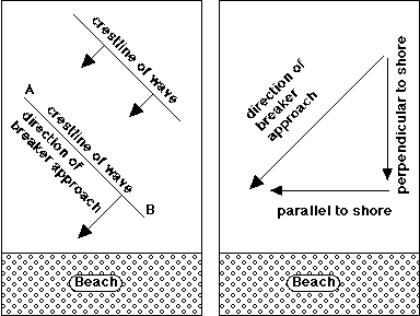
|
Season |
Berm |
Movement of Longshore Bar |
Wave Conditions |
|
Summer |
large / small |
onshore / offshore |
large / small |
|
Winter |
large / small |
onshore / offshore |
large / small |
(5) The table below is of seasonal beach profile data collected in southern California by Dr. William Prothero of UC-Santa Barbara Geological Sciences. These beach profile measurements were made at three different times during the year. Use these data to plot profiles of the beach during the different seasons.
|
Distance (m) along profile |
3 |
6 |
9 |
12 |
15 |
18 |
21 |
24 |
27 |
30 |
|
SUMMER |
45 |
40 |
45 |
50 |
50 |
55 |
90 |
120 |
150 |
180 |
|
WINTER
|
45 |
40 |
45 |
50 |
95 |
120 |
145 |
165 |
180 |
190 |
|
SPRING
|
45 |
50 |
100 |
130 |
155 |
170 |
180 |
190 |
195 |
200 |
Plot these profiles on a piece of graph paper or with some graphing software. Label them appropriately (i.e., "summer," "winter," "spring" - use a different line style for each profile).
Read these plotting instructions carefully:
• At the top left-hand corner of the page, label the origin (the zero point).
• The vertical axis should go from 0 to 250 centimeters, with zero on top and 250 on the bottom. Note that higher values will plot lower on the graph.
• The horizontal axis should go from 0 to 40 meters.
Note: You will have to choose the correct intervals for the axes.
• Label the axes.
• Begin plotting the data. When you plot the other profiles, use a different color or line style for each one, and make sure they are properly labeled.
(6) The vertical and horizontal scales on your plot are different. Calculate the vertical exaggeration (V.E.) by dividing the horizontal distance per division on your graph paper by the vertical distance per division. Be sure to use the same units on the distances.
(7) Once all the profiles have been graphed, label the location of the features you can identify (the berm, the beach face, etc.).
Last update: March 14, 1999
http://dusk.geo.orst.edu/oceans/lab7.html
Dawn Wright & Bob Duncan © 1999