
[ home port | lectures | labs | surf | email prof. ]
a balance between a pressure gradient and Coriolis deflection
Western boundary currents faster
pressure effects are negligible.
Density near surface:
Hence they retain the temperature and salinity signature established at the sea surface.
Mixing is slow because flow rates are very slow.
Intermediate Waters
Deep and Bottom Waters
At the equator:
Water that sinks at the poles takes about 1000 years to rise back to the surface.
Last update: April 27, 2000
Ekman Transport (Figure 6-6)
Mounds of Water (Figure 6-9)
Ocean Currents
Thermohaline
Initiated at the surface by temp/salinity
Vertical circulation
Primarily at depth
Deep-Ocean Circulation
Powered by thermohaline circulation due to density differences between water masses. The differences reflect:
Temperature - thermal
Salinity - haline
"You are my DENSITY!"
Density of water determined primarily by temperature and salinity
-- George McFly
Evaporation
Precipitation
Runoff, river drainage
Water Masses at Depth
When water masses sink they are isolated from the major processes that affect density.
Water Mass Types
Central Waters
e.g., NPCW = North Pacific Central Water
e.g., NPIW = North Pacific Intermediate Water
e.g., CoW = Common Water
NADW = North Atlantic Deep Water
AABW = Antarctic Bottom Water
"T-S" Diagrams
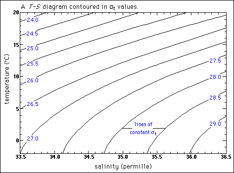
Image courtesy of Lamont-Doherty Earth ObservatoryWater Masses on T-S Diagram
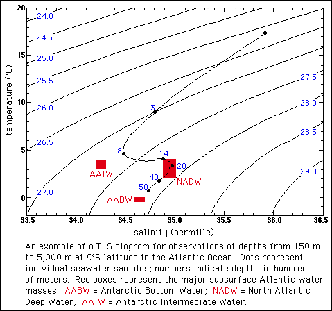
Image courtesy of Lamont-Doherty Earth Observatory
Thermohaline "Conveyer Belt" (Figure 6-16b)
At the poles:
cold, salty dense water sinks and spreads into the ocean basins along the bottom.
warm low density water floats as a lens slowly moving poleward.
Location of Water Profiles (Figure 6-14)
Salinity Profile of the W. Atlantic (Figure 6-14)
Temperature Profile of the W. Atlantic (Figure 6-14)
Water Mass Structure of the Atlantic (Figure 6-15)
Water Mass Structure of the Indian Ocean (Figure 6-15)
Salinity Profile of the East Pacific (Figure 6-14)
Temperature Profile of the East Pacific (Figure 6-14)
Water Mass Structure of the Pacific (Figure 6-15)
Why is the Atlantic saltier?
Why is deep water formed in Atlantic?
Look again at Figures 6-16b and 6-4 for a clue.
http://dusk.geo.orst.edu/oceans/lec14H.html