Tools & Techniques of Deep Ocean Geography
This paper appears in
The Professional Geographer, 51(3): 426-439, 1999.
© Copyright reserved by Dawn Wright,
Blackwell
Publishers, and the Association of American Geographers.
May be freely distributed electronically in whole or in part, but please keep
this notice
attached and do not alter the text. This article is slightly
longer than the final published version.
Getting to the Bottom of it:
Tools, Techniques, and Discoveries of
Deep Ocean Geography
Dawn Wright
Department of Geosciences, Oregon State University, Corvallis,
OR 97331 USA
Abstract
The initial impetus for developing a specialty in ocean geography
resulted from the need to resolve applied problems in coastal resources, as
opposed to development of oceanographic research methods and concepts. However,
the development in the last 10-20 years of sophisticated technologies for ocean
data collection and management holds tremendous potential for mapping and
interpreting the ocean environment in unprecedented detail. With the
understanding that ocean research is often very costly, yet deemed extremely
important by large funding agencies, geographers now have the opportunity to
perform coastal and marine studies that are more quantitative in nature,
to formulate and test basic hypotheses about the marine environment, and to
collaborate with geographers working in corollary subdisciplines (e.g., remote
sensing, GIS, geomorphology, political geography as pertaining to the Law of
the Sea, etc.), as well as with classically-trained oceanographers. This piece
reviews, for the non-specialist, the newest advances in mapping and management technologies for undersea
geographic research (particularly on the ocean floor) and discusses the
contributions that geographers stand to make to a greater understanding of the
oceans. Key Words: marine geography, ocean floor mapping, bathymetry,
seafloor spreading, underwater vehicles.
"You cannot discover new oceans unless you have the courage to lose sight of
the shore."
- Anonymous
The Evolution of Ocean Geography
Of the many forms of representation that geographers use to characterize the
Earth - numerical, statistical, graphical - maps often come to mind as the
foundation of geographic inquiry, particularly in the minds of the public
(Woodward 1992). And yet geographers have been largely absent from the push to
map the final frontier of the planet: the oceans. Indeed, if one were to define
marine or ocean geography as that branch of geography concerned with "location,
place, region, and space" (Couclelis 1992) on the surface and bottom of the
oceans, as well as the distribution of life within the water column (e.g.,
Kracker this issue) then a survey of published literature within recent decades
would reveal that this sort of work is not being done by geographers.
Indeed, as geography has traditionally embraced both the physical and
human sciences and sought to provide a bridge between the two, the study
of the oceans beyond the realm of the nearshore has escaped attention.
Steinberg (this issue) ably discusses various reasons for this omission.
Within the past 10 years, as the greater scientific community has
seen a dramatic increase in support for research into global Earth systems
and the effects of human-induced change, geographers began to
broaden their focus past traditional boundaries. Ocean geography as it was
known in the past is no longer limited to the coast, but is slowly
embracing studies of the deep ocean realm, as well as lakes and small
seas. Such an embrace may be very costly however, both in research
dollars and time spent at previously inaccessible study sites. It will
therefore be important for geographers to continue fostering
interdisciplinary relationships with classically trained oceanographers and
ocean engineers to secure the necessary funding along with a broader
sense of community with these scholars, a theme that will be discussed in
the paper's conclusion. Steinberg (this issue) states that terrestrial
geographers may learn much from the study of ocean space. Similarly,
classical oceanography (the broad science of physics, biology, chemistry,
geology, and geophysics applied to the ocean realm) may glean much
from a geographical approach. For example, as will be discussed below,
several important scientific questions have arisen from a
decidedly geographical approach to interpreting ocean floor data, focusing
on geographic information systems (GISs). As Mark Monmonier noted,
"what a friend we have in GIS" (Monmonier 1993), which has ushered in
new ways of analyzing these data, that in turn have facilitated new
interpretations. Indeed, research issues endemic to oceanographic
applications of GIS, such as the handling of spatial data structures
with the ability to vary their relative positions and values over time,
geostatistical interpolation of data sparse in one dimension as compared to
the others, volumetric analysis, and the input and management of very
large spatial databases will advance the body of knowledge in GIS design
and architecture, as well as the body of knowledge in the broader field of
geographic information science. If one accepts the case made by Steinberg
(this issue) for ocean space being viable research fodder for geographers,
then surely ocean mapping is a viable research area in geographical
information science.
New opportunities continue to arise for geographers to venture
offshore. One of the most pressing is in the realm of mapping the deep
ocean floor, where, we have made more progress in the past 20 years
mapping the surface of neighboring planets than we have in the past 500
years mapping the abyss of our own planet (Macdonald et al. 1993a). However, the development in the
last 10-20 years of sophisticated technologies for ocean data collection and
management hold tremendous potential for mapping and interpreting the ocean
environment in unprecedented detail. What follows is a review of these emerging
technologies and how they are being applied to the ocean floor, as well as case
studies that illustrate the important role that the coupling of geographic
techniques with these technologies play in linking observed patterns to
physical processes.
Ocean Mapping Technology: From the Entire Globe to a Single Structure
"Seeing" Through Inner Space
When viewed from space, the Earth appears strikingly as a planet of
water, with 70% of it surface covered by a fluid envelope averaging 5000 m in
depth. This envelope a vast inner space which, along with the underlying ocean
floor, is still only dimly perceived by humans. What can be perceived of the
water column and ocean floor must be done mostly with the aid of sound, as
sound waves are transmitted both farther and faster through seawater than
electromagnetic energy. In order to "see" the ocean floor for instance, sound
is essential not only for determining depth to the bottom, but for detecting
varying properties of the bottom. Sound reflects back after striking an object
on the seafloor and the intensity of this reflection, or backscatter can be
used to sense the shape of objects or the character of the bottom (e.g.,
heavily sedimented and thus non-reflective or glassy with fresh lava flows and
thus extremely reflective). Depths are commonly measured by timing the two-way
travel time of a sound pulse released from a research vessel, towed instrument,
or vehicle. As the speed of sound in seawater varies linearly with temperature,
pressure, and salinity, the conversion of travel time to depth must take this
into account (Kennett 1982).
Global Scale Via Satellites
In terrestrial terms, research vessels and their associated instruments and
vehicles must travel quite slowly during mapping efforts (anywhere from 1 to 12
knots, or the speed of an average bicycle commuter). In order to map the global
ocean floor at this rate it would take approximately 125 years and $5 billion
(Sandwell 1995; Yulsman 1996), even with the latest acoustic mapping tools
described below. Fortunately, satellite determinations of sea surface height
can be used to estimate ocean floor topography on small scales (covering the
globe in a little over a year at a cost of ~$80 million) (Yulsman 1996),
leaving shipboard techniques to tackle the larger scale mapping efforts. Radar
altimeters aboard satellites take advantage of the fact that the surface of the
ocean bulges outward and inward in a fashion mimicking the topography of the
ocean floor because of minute variations in the earth's gravitational field.
Altimeters can measure these bumps and dips in the geoid height to sub-meter
vertical resolution. For example, the Geosat satellite launched by the U.S.
Navy in 1985 mapped geoid heights to a vertical resolution of 0.03 m with a
horizontal resolution of 10-15 km (Sandwell 1995). Recently declassified data from Geosat, combined with data from the ERS-1 satellite of the European Space Agency, have
provided the best detailed view of the ocean floor on a global scale, revealing
structures never before seen, particularly in the southern oceans where ships
have difficulty in rough weather (Sandwell 1995; Figure 1).
|
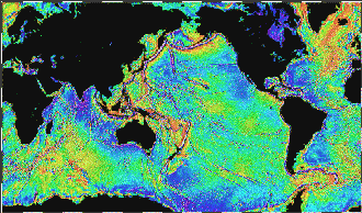
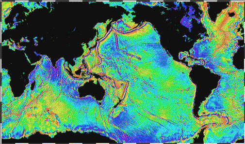
Figure 1:
Global map of ocean floor gravity from Geosat and ERS-1
satellite altimetry (Sandwell 1995). Estimates of ocean floor topography may be
derived from these data. Prominent among the visible features in the gravity is
the Mid-Atlantic Ridge, which appears as a faint seam along the center of the
north Atlantic Ocean. The deep trenches of the north and west Pacific, as well
as thousands of seamounts, are also visible.
Click on the image for an expanded view
|
Regional Scales Via Ships and Towed Vehicles
While satellite gravity data reveal all discrete ocean floor structures
larger than 10 km horizontally and 1 km vertically, operations at sea are still
required to detect and interpret structures at a higher resolution. Surveys at
this regional scale are carried out with multibeam swath mapping systems that
are either mounted to the hull of a research vessel or towed behind the vessel
as a vehicle. These systems are termed "multibeam" because their transmitting
arrays send out several simultaneous, downward-looking beams of acoustic energy
across the track of the vessel, creating a 1-10 km-wide swath of coverage
(depending on the water depth). Although limited to vessel speeds of 10-12
knots, these multibeam swath mapping systems rapidly generate high resolution
bathymetric maps (i.e., of depths to the ocean floor) over much larger areas of
seafloor than their single beam predecessors of the 1950s and `60s. One
hull-mounted system that is now accepted as a de facto standard within the
marine mapping community is Sea Beam, whose 16 beam-array can map ~1200
km2 of seafloor per day at a contour interval of 10-20 m (the
coverage of a single-beam system is ~400 km2 per day at a 100-200 m
contour interval). The Sea Beam 2000 series was introduced in the early `90s
with a 121-beam array (Figure 2) that often triples the bathymetric mapping
output of the original Sea Beam system (Asada 1992).
|
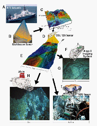
Figure 2:
Composite drawing of the various state of the art technologies
available for ocean floor mapping in a nested investigative strategy
(after Fornari et al. 1997; reprinted by permission of Woods Hole
Oceanographic Institution, Deep Submergence). Starting from the upper
left, the R/V Atlantis of the Woods Hole Oceanographic Institution (A)
is equipped with a hull-mounted Sea Beam 2100 multibeam swath
mapping system (B) for small scale mapping of large areas of the ocean
floor. Sea Beam 2100 data were used to construct the perspective image
at the top right (C). Detailed, near bottom surveying of selected areas
mapped by Sea Beam 2100 is possible with the DSL 120 towed vehicle
(D), which can map out swaths of sea floor up to ~1 km total width (E),
followed by mapping with the Argo II vehicle (F) on the order of ~3 m
(G). At an even larger scale, detailed imaging and sampling are possible
with either the Alvin submersible (H), on the order of 5 m, or the
remotely operated vehicle (ROV) Jason on the order of ~0.75 meter.
Click on the image for an expanded view
|
Several towed vehicles have been developed to work in combination with
hull-mounted systems such as Sea Beam. These vehicles are equipped with
long-range, side-looking sonars that measure not only the traveltime but
the strength and direction to an ocean floor reflector. So in addition to
high-resolution bathymetric maps, these vehicles provide the acoustic
equivalent of an aerial photograph of the ocean floor (called sidescan sonar
imagery). The vehicles are usually towed in order to shield their sonars
from ship noise and propeller turbulence and to enable their use with more than
one research vessel during a field season. Towing depth is at least below the
thermocline (~150 m depth) to minimize acoustic wave bending due to temperature
changes and to give the vehicle greater stability than the pitch, roll, and yaw
that the vehicle would be subjected to at the surface. Currently the most
popular towed vehicles among North American marine scientists are the HMR-1
vehicle of the Hawaii Mapping Research Group, University of Hawaii (towed 150 m
below sea surface, 20-30 km swath width), GLORIA II of the U.S. Geological
Survey (towed 30-60 m below sea surface, 14-60 km swath width), and DSL 120 of
the Deep Submergence Laboratory (DSL), Woods Hole Oceanographic Institution
(towed ~75 m above the ocean floor, 300 m swath width; Figure 2). Argo
II, also of the DSL, is a towed vehicle primarily for visual imaging
(Figure 2). It is towed ~10 m above the ocean floor and gathers real-time
video, 35 mm photographic, and electronic still camera digital imagery, as well
as side-looking sonar, bathymetric, and often magnetics, water conductivity,
and temperature data (Fornari et al. 1997).
Hull-mounted swath mapping systems and towed vehicles have led to some
remarkable discoveries, particularly along the mid-ocean ridge, the largest,
most striking feature on the planet at a length of 70,000 km throughout all the
world's ocean basins. The mid-ocean ridge comprises 95% of all the plate
tectonic boundaries found on Earth, and dominates the volcanic flux of the
planet, creating an average of 20 km3 of new oceanic crust annually,
which in turn contributes up to 66% of the heat lost from the interior of the
Earth (Macdonald et al. 1991). Bathymetric maps produced by swath mapping and towed vehicles, in
concert with various geophysical studies, have shown that instead of a
continuous rift valley as originally conceived, the ridge consists of segments,
each a few kilometers in length and linked end-to-end along the axis of
seafloor-spreading. This strongly suggests that processes in the lower crust
and upper mantle respond to plate separation in a discontinuous, but systematic
way (Macdonald et al. 1991). Many more maps and bottom observations are needed to document the amount
of extension along the ridge and to characterize degrees of segmentation.
Local Scales Via Submersibles
Mapping is of course a fundamental component of ocean floor
investigation but must often go hand-in-hand with sample collection of rocks,
biota, and sediments from smaller areas on the ocean floor (typically 0.1-1
km2). It is here that the submersible becomes a valuable and
necessary element of deepsea investigative capability. The submersible
couples not only acoustic, but visual imaging with a system
that permits complex and interactive sampling and equipment deployment, usually
via powerful and dexterous robotic arms (DSSC 1994). The fundamental limitation
of the vehicle is the human component. As a consequence of needing to
provide life support for the occupants, bottom time is limited to an average of
8 hours, no more than 12. The time, however, is well spent as often the scientist returns
from a submersible dive with a completely different, hypothesis-altering
perspective of the ocean floor (e.g., Martin 1992; Haymon et al. 1993; Wright 1996).
Underwater vehicles with human occupants date back to the 1600's. However,
the first true submersible, so classifed because of it maneuverability,
was the Trieste, which took Jacques Piccard and Donald Walsh to
a record-breaking depth of 10,912 m in 1960 (Piccard 1961). In the wake
of Trieste's success, the number of scientific submersibles grew
dramatically, continuing to the present with the Americans, the Japanese,
and the French leading the way.
The most distinguished and heavily-used of
U.S. submersibles is Alvin (Figure 2), famous for its 1986 visit to the
wreck of the H.M.S. Titanic (Ballard 1987). Over the last 30 years
Alvin has taken over 8300 observers to the ocean floor during more than 2800
dives over the time span of 18,000 hours underwater (DSSC 1994). In 1974 Alvin
and the now retired French submersible Archimede, dove on the
Mid-Atlantic Ridge as part of Project FAMOUS (French-American Mid-Ocean
Undersea Study), which helped to confirm the theory of plate tectonics and
continental drift. Sea Cliff and Turtle, both of the U.S. Navy,
are also in use by the North American scientific community, and the French
submersible, Nautile is the distinguished workhorse of the European
scientific community.
Nested Strategies With Remotely-Operated Vehicles (ROVs)
During the last 25 years of high-resolution exploration of the ocean floor,
there have been not only fundamental, exciting scientific discoveries made (see Macdonald et al., 1993a; Macdonald et al. 1993b; Detrick and Humphris 1994; DSSC 1994; Fornari et al. 1997 for a fuller description),
but also much has been learned about what combination of tools is needed to
fully investigate the interdisciplinary scientific questions at hand. For
example, a towed vehicle collecting swath bathymetry and side-looking sonar,
towed ~100 m off the bottom at a speed of 1.5 knots, may image ~130
km2 of ocean floor per day. A similar platform with camera/video
capabilities, towed ~10 m off the bottom at 1 knot would image less than 1
km2 of ocean floor per day. A manned submersible with a bottom time
of 6 hours may traverse 1-3 kilometers of ocean floor during a dive or carry
out sampling or experimental tasks at a single location. Given these spatial
limitations, a nested investigative strategy (analogous to "multistage"
in terrestrial remote sensing) is in order (Fig. 2): (1) use the
high-resolution mapping capability of the towed vehicle to resolve properties
of the ocean floor at scale large enough to place the results of a near-bottom
investigation into a regional context; (2) deploy a submersible, like a dart
aimed at a specific target, to investigate, sample, and characterize a limited
number of diagnostic locations with the regional framework defined by the towed
vehicle (DSSC 1994). As effective as this strategy is, it is still limited by
the short time scale of the manned submersible investigation.
The last 10-15 years have seen the development of remotely operated vehicles
(ROVs) for scientific and industrial applications in shallow coastal waters
(less than 1000 m). ROVs have all the characteristics of a towed vehicle with
an additional capability to maneuver on a tether for high-resolution
investigations and interactive tasks on the bottom. In the last decade ROVs
have been aggressively developed for scientific research applications in deep
water. A host of engineering problems unique to working at great depths have
largely been solved, and the technological innovations pioneered for
shallow-water ROVs (e.g., lights, cameras, thrusters, robotics, etc.) have been
adapted by their deep-water counterparts. Like the towed vehicles for deep
water, these ROVs are powered by a conducting cable to the surface ship and can
carry out scientific missions for several days to weeks on the bottom; like
submersibles, these ROVs can remain stationary and perform complex sampling
and imaging tasks (DSSC 1994). An operator may control the ROV from a distance
using either full robotic control, manual control, or a continuous series of
combinations between the two. On the whole these ROVs, when well navigated, can
carry out mapping tasks at a range of scales that are unprecedented both on the
ocean floor and up in the water column. The m- to cm-scale sonar and
image-based maps that can be produced are beyond the resolution of the
hull-mounted and towed systems and are achieved much more effectively than
submersibles. The marine science community is just beginning to ascend the ROV
"learning curve" in terms of system configuration and implementation, but
clearly the ROV represents a significant step foward in humankind's ability
to characterize the global abyss (Newman and Robison 1992; Travis 1991; DSSC 1994; Robigou and Ballard 1994).
Medea-Jason, developed by the DSL, has seen a marked increase in
scientific service over the last 5 years. Medea-Jason is a dual vehicle
ROV system, with Medea serving as support linkage to both the ship
and Jason, and Jason functioning as a multi-sensory imaging and
sampling platform (Figure 2; Robigou et al. 1993; DSSC 1994). Also available now are Ventana and Tiburon of
the Monterey Bay Aquarium Research Institute (Newman and Stakes 1993; Stakes et al. 1993), and the Advanced Tethered
Vehicle of the U.S. Navy (DSSC 1994).
In addition to ROVs, autonomous underwater vehicles (AUVs), which are still
largely developmental, hold great potential for future mapping and data
collection as they are completely untethered. Elimination of the tether frees the vehicle
from the surface vessel, removes the need for large and costly handling gear,
and allows for continuous operation up to 1 year. Communication with the
vehicle through the water and over such a long time period is still extremely
difficult, as is equipping the vehicle with the necessary on-board intelligence
to successfully complete all of its tasks without human supervision. Two
free-swimming vehicles that have been tested recently for deep-water science
missions are the Odyssey II and the Autonomous Benthic Explorer (ABE;
Figure 3), both developed at the DSL of WHOI. In 1995 ABE completed its first
official science mission by successfully gathering magnetics data and visual
imagery from the CoAxial segment of the Juan de Fuca Ridge in the northeast
Pacific (Yoerger et al. 1995; Tivey et al. 1997).
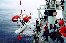
|
Figure 3:
Photograph of ABE (Autonomous Benthic Explorer) being
deployed over the side of the R/V Atlantis II during its first series ofofficial scientific missions to the Juan de Fuca Ridge, NE Pacific, summer of
1995, Atlantis II Cruise 132-12 (photograph taken by the author).
Note similarity in design of the vehicle to the Starship Enterprise . .
Click on the image for an expanded view
|
Issues in Ocean Spatial Data Management
The introduction of these sophisticated tools has necessitated the development
of reliable data management systems for the various data streams. The cost of
acquiring the data alone (seagoing operations run upwards of $25,000 per day)
justifies the development of dedicated systems for the management and
integration of these data. And there is always the goal of using these systems
as an analysis tool to optimize scientific interpretations and facilitate the
rethinking or reformulating of hypotheses. As mentioned before with nested
surveying strategies, bathymetric data from a swath mapping system located
underneath a ship may need to be georeferenced to underwater video
images or sidescan sonar data collected from a vehicle towed behind the
ship and several meters above the ocean floor, to sample sites,
observations, temperature measurements, etc. collected from a submersible or
ROV launched away from the ship and operating directly on the
ocean floor, to earthquake data obtained from an ocean bottom seismometer
anchored on the seafloor. The data produced by these different sensors will
invariably have different dimensionalities, resolutions and accuracies. And as
transmission rates of up to several Gb per day at sea become more and more
commonplace the ability to assess ocean floor data collected at these different
scales, in varying formats, and in relation to data from other disciplines has
become crucial. Here geography has made a contribution through the introduction
of GISs, that fulfills not only the
requirement of data integration but of combining or overlaying data of the same
dimensionality. This also serves as an efficient means of assessing the quality
of data produced by one instrument as compared to another.
Geographers have also contributed greatly to assessing and solving many
problems that apply very much to the ocean environment, including: the
management of very large spatial databases (Star 1991; Stonebraker et al.
1993; Frew 1994), uncertainty and error propagation (Goodchild and
Gopal 1989; Buchmann et al. 1989; Burrough and Frank 1996; Heuvelink
1998), the designation of "core" or "framework" data sets for sharing and
archiving (Frank et al. 1995), and the development of standards for spatial
data and metadata, i.e., information about data (National Research
Council 1993; Federal Geographic Data Committee 1995).
The development of appropriate metadata (information about data) and metadata
standards for ocean floor and other types of oceanographic data is also
an important issue. This is pertinent to oceanography regardless of whether or
not the data have been used in a GIS context. The growth in information
technology has led to an explosion in the amount of information that is
available to researchers in many fields. This is particularly the case in the
marine environment where a state-of-the-art "visual presence" (through
real-time video or 35-mm photography) may result in the acquisition of data
that quickly overcomes the speed at which the data can be interpreted. The
paradox is that as the amount of potentially useful and important data grows,
it becomes increasingly difficult to know what data exist, where the data are
located, and how the data can be accessed. In striving to manage this
ever-increasing amount of data and to facilitate their effective and efficient
use, metadata becomes an urgent issue. As this article goes to press, the
Federal Geographic Data Committee will have reviewed the first proposals ever
to address the issue of standards development for coastal and marine metadata,
under the National Spatial Data Infrastructure (NSDI) Cooperative Agreements
Program (Mapping Science Committee, 1994). One of the most ambitious and effective efforts to date in the area
of ocean data management and metadata creation is the Statewide Ocean Resource
Inventory (SORI) project, funded by the National Oceanic and Atmospheric
Administration (NOAA) through the Florida Coastal Management Program. The SORI
project aggressively fills gaps in ocean floor and other types of data along
the Florida coast, maintains them in a GIS and executes a distribution
mechanism via the World Wide Web, with the goal of providing information in a
format that can be used by those developing Florida's ocean policy (Westlake et al. 1997; Friel et al. 1998). As a
result of various issues raised by Florida's Ocean Policy Roundtable, NOAA's
office of Ocean and Coastal Resource Management has formed a partnership with
the NOAA Coastal Services Center to advance ocean GIS throughout the South
Atlantic region (Fowler and Gore 1997; Friel et al. 1998). An ambitious
effort on the Gulf coast was the Water Quality Information System (WaterQUIS)
of the University of Alabama, with a goal of characterizing the spatio-temporal dynamics and linkages between various physical, chemical, and biological
processes of relevance to water quality conditions and forecasts throughout
the Mobile Bay watershed.
On the west coast, and
directly related to the ocean mapping technology described previously, is the
Vents GIS project, funded by the Vents program of the NOAA Pacific Marine
Environmental Laboratory. The Vents GIS focuses on geological, geophysical,
chemical, and biological data from the Juan de Fuca seafloor spreading center
and is the first major GIS project designed exclusively for deep ocean data and
metadata (Fox et al. 1996; Wright et al. 1997).
It integrates data from multiple conventional sensor and sample analysis
systems, as well as interpretive information from video and sidescan
sonar data analysis. One important component in the effective
implementation of the entire data managment infrastructure has been the
definition of a semantic model that allows users and designers to capture
the meaning of the various databases. A semantic data model essentially
defines objects, relationships among objects, and properties of objects,
thus providing a number of mechanisms for viewing and accessing a
database schema at different levels of abstractions (Ram, 1995). A
number of semantic data models have been developed and described in the
computer science and information management literature (e.g., Hull and
King 1987; Peckham and Maryanski 1988; Miura and Moriya 1992/93;
Mann and Haux 1993; Yazici et al. 1995). The successful application of a
marine geography database is closely linked to various unique
requirements for data acquisition and near real-time analysis, previously
considered only by Gritton et al. (1989) for undersea data from a single
vehicle. These requirements are considered by Wright et al. (1997) for
multiple data types from a variety of sensors in the development of a
semantic data model for the southern and central portions of the Juan de
Fuca Ridge. Currently in progress, and based on that semantic data model,
is the development of a metadata archiving and distribution mechanism in
support of the NSDI for the northernmost segment of the Juan de Fuca
Ridge (see www2.ocean.washington.edu/gis).
Related to the concept of metadata is that of spatial lineage, or the history
of how the spatial data were derived. A report of lineage is
therefore intended to serve as a communication mechanism between the data
producer and the user, a kind of "truth in labeling" statement regarding the
nature and quality of GIS-derived products (Lanter 1990). Because oceanographic data of all
kinds often come from a variety of sensors, differing in resolution and
covering different geographical areas, lineage documentation is especially
important for assessing data quality, data history, and error propagation. The
integration of remotely-sensed images (such as the aforementioned Geosat
gravity data) with in situ data is an important consideration as well.
However, the values in remotely-sensed images represent parameters in an area
whereas the in situ data are point observations.
The fact that datasets have been routinely collected at different times is a
further consideration. The most recent data set is usually assumed to be the
most "correct," provided that no special error conditions are known to have
affected the sensor. In practice, small variations in time within or between
datasets gathered at sea are often ignored to simplify the analyses and modeling
. Mechanisms will need to be put in place to provide information on the
source of data input to the GIS, as well as on database and cartographic
transformations performed on the data within the GIS, and on input/output
relationships between source-, derived- and product-GIS data layers. Lineage
documentation is still rarely used in GIS because its structure has not been
well understood or well implemented (Lanter 1990). The studies of Lucas et al. (1994), one
of the first to investigate metadata and lineage requirements specifically for
oceanographic applications, and Lanter (1991) are important exceptions.
New Scientific Discoveries: From Pattern to Process
The list of scientific discoveries in the field of ocean floor
mapping continues to grow. To provide an example, the following is a
description of oceanographic fieldwork recently completed in the East Pacific
with the aid of geographers, many of whom are beginning to make important
contributions not only to the management of data gathered from the deep ocean
but also to the science derived from it (see also the works of Mason et al. 1994; Gold and Condal 1995; Li et al. 1995; Bobbitt et al. 1997; Goldfinger et al. 1997).
In October to December of 1996, a nested survey strategy was used to map and
interpret the narrow crest of the superfast-spreading southern East Pacific
Rise (EPR) at 17-18 ° S (Figure 4; Haymon et al. 1997). The major goal of
the survey was to test the hypothesis (based on Argo I data from the EPR
at 9-10 ° N) that along-strike thermal gradients set up by the segmented
pattern of magma supply from the upper mantle to fast-spreading mid-ocean
ridges exert primary control on the distribution and types of hydrothermal
vents and vent biota, as well as on variations in fissuring and other
fine-scale volcanic and tectonic structures along the axial zone. Along a
segment of ridge only 45 km long, the sub-surface geophysical data of Detrick
et al. (1993) show that an axial magma chamber (the portion of the upper mantle
that supplies magma to the seafloor) in this region changes along-strike from a
flat-topped body at relatively constant depth of 1200 m, to a peaked cupola or
spike that intrudes to within 800 m of the seafloor at ~17 ° 25'-27'S. This
is in marked contrast with the only other magma chamber to be imaged along the
EPR, a flat-topped chamber beneath the EPR at 9-10 ° N, and represents the
most extreme along-strike variation in thermal gradients known to exist on the
global mid-ocean ridge system.

|
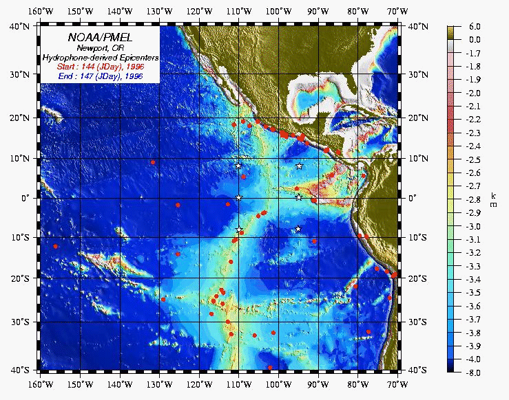
Figure 4:
Map of the topography of the ocean floor in the SE Pacific,
showing the southern East Pacific Rise (public-domain data courtesy of NOAA). Stars show
the location of 6 hydrophones deployed by the NOAA Pacific Marine Environmental
Laboratory to track seismic activity along the Rise. Study area described in
the article is located at 17-18 ° S.
Click on the image for an expanded view
|
In order to precisely locate the axial zone in this superfast spreading
environment (full spreading rate at ~14 cm/yr; Hey et al. 1995), the DSL
120 was towed at an average height of ~75 m above the ocean floor for the
collection of high-resolution bathymetry and 120-kHz sidescan sonar imagery.
The DSL 120 data made possible the determination of how closely to space the
Argo II tracklines. Argo II was then towed at an average height of 9
m above the ocean floor to map hydrothermal vents, fissures, fault scarps, lava
flow ages and morphologies, and biological communities with video, 35 mm,
electronic still camera imagery, as well as with 200 kHz sidescan sonar, a 675
kHz down-looking scanning sonar, and a conductivity-temperature-depth sensor.
These observations, essential for studying the variable, fine-scale character
of the ocean floor, were digitally logged in real time at sea and then merged
with the vehicle's navigation.
Fifteen 45 km-long, axis-parallel lines through the axial zone with line
spacings of 10-30 m provided 100% saturation coverage where the axial zone is
less than 100 m wide, down to a minimum coverage of 45% where the axial zone
widens to 400 m (Figure 5). Video and photographic coverage during the survey
included more than 6 million m2, yielding a tremendously large and
diverse data set that would have been extremely difficult to interpret
without input to a GIS. This allowed the seagoing scientific party to
immediately archive four different types of seafloor observations
(hydrothermal, volcanic, tectonic, and biological) in an organized and
consistent manner, and to interpret plots of the locations of vehicle
tracklines and observational features, most notably locations where the Argo
II video camera crossed a fissure, a high- or low-temperature hydrothermal
vent (smoker, smoky or cloudy water issuing from vent), a hydrothermal deposit
(mound, chimney, edifice, hydrothermal sediment/staining), scattered biota or
dense animal community, lava flow fronts, and isolated fault scarps, as well as
Sea Beam bathymetric data gathered before the expedition. Additional overlay of
vehicle tracklines on any combination of observations was useful for noting
gaps or scarcity in data coverage or to test the validity of distributions,
particularly in portions of the survey area where density of trackline coverage
is minimal. Buffering of tracklines along which particular ages of lavas were
observed were useful for estimating the areal extent of these flows after the
methodology of Wright et al. (1995).
|
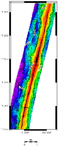
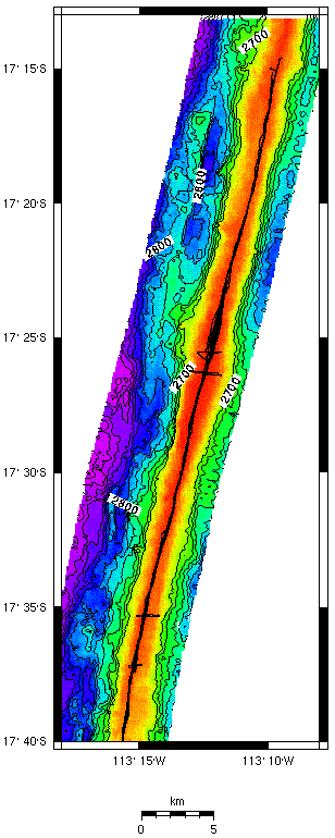
Figure 5:
Map of the southern East Pacific Rise from 17 ° 14-40'S
showing the tracklines of the Argo II vehicle along the axial zone.
Bathymetry is from a single swath of Sea Beam 2000 data collected by Scheirer
et al. (1996). Contour interval is 20 m. Contours shallower than 2700 m masked
to allow for display of the Argo II tracklines. Map projection is
Mercator.
Click on the image for an expanded view
|
Several important scientific questions have arisen from a GIS approach to
analyzing these data, chief among them the changing patterns of fissuring with
respective to the ages of lava flows. For instance, it was thought previously
that the widest (presumably deepest) fissures on the mid-ocean ridge are not
primarily eruptive, and should be most abundant in areas of older lava flows,
having increased in width with time. However, this was not observed during the
Argo II survey. Some of the widest cracks have been mapped at the "Spike"
region (17 ° 25'S) where an eruption of the ridge crest is estimated to have
occurred some time in 1993-1994 (Auzende et al. 1996). These fissures may be
deep enough to reach a layer of magma intrusion several hundred meters below
the seafloor, which in turn is linked to the axial magma chamber imaged by
Detrick et al. (1993). Although Argo II video observations and sonar
data, as well as DSL 120 sidescan and bathymetry, are still being
processed and GIS maps still being prepared, it is hypothesized that the
narrowest, presumably shallowest, fissures correspond to the narrowest, oldest,
and most hydrothermally inactive portions of the ridge crest in the survey
area. The wide fissures are hypothesized to be the deepest and thus primarily
eruptive in origin, whereas the narrow, shallow cracks may be primarily
tectonic, and associated more with far-field plate stresses or thermal
contraction due to cooling of the crust.
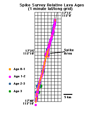
Figure 6 is a simple map created in a GIS while at sea during the survey showing the
distribution of axial lava ages upon which these hypotheses are based. It shows
a first-order assignment of relative lava ages for the Argo II survey
areas based on the apparent thickness of small sediment ponds in between lobes
of lava (the more sedimented a lava flow is, the older it is, having been
created at the axis of seafloor spreading and then carried away from the axis
over a period of time long enough for sediment to accumulate on it). Haymon et
al. (1991) estimated Age 1 lava flows to be <50 years old, Age 2 flows to be
~100-1000 years old, and Age 3 lavas to be 1000-5000 years old. However, based
on Nautile submersible observations made in the survey areas during a
1994 dive program (Auzende et al. 1996) and Alvin observations during
1991 and 1992 dives to the EPR at 9-10 ° N (Haymon et al. 1993),
these estimates are now believed to be too old. Absolute age dating of lava
flows in this area and calibration of an absolute age scale are planned for the
future.
|
Figure 6:
Map resulting from a GIS analysis at sea showing the
approximate, along-strike distribution of relative axial lava ages in the area
surveyed with Argo II. Map projection is Mercator.
|
In the survey area there is a demarcation between older lavas to the north of
the "Spike" region at 17 ° 25'S and younger lavas to the south along the
length of the ridge (Figure 6). The pattern of lava ages appears to be driven
by the process of laterally-propagating intrusions of magma (dikes), moving
southward along the strike of the EPR away from the shallow, localized site of
magma injection at 17 ° 25'S.
The high rates of spreading, crustal formation, and even seismicity on the
southern EPR, in comparison to slower-spreading ridges such as the Mid-Atlantic
Ridge, beg the question of whether volcanic and tectonic events become larger
and more intense, or simply much more frequent (Mottl et al. 1996).
Still to be determined are the implications of these findings for
harnessing geothermal energy, garnering oil and mineral wealth
(especially the copper, iron, manganese, and zinc found at hydrothermal
vents), assessing seismic hazard (particularly tsunami detection and
emergency preparation), and finding natural substances that may yield
new medicines or new classes of industrial chemicals. Pharmaceutical and
biotechnology companies are already analyzing the sulfur-eating bacteria
clustered around hydrothermal vents, along with various species of
deepsea fish and plants, in the search for a substance that might someday
turn into a miracle drug (Lemonick 1995). Says Bruce Robison of the
Monterey Bay Aquarium Research Institute, as quoted by Time magazine:
"I can guarantee you that the discoveries beneficial to mankind will far
outweigh those of the space program over the next couple of decades. If
we can get to the abyss regularly, there will be immediate payoffs"
(Lemonick 1995).
As we cross the physical/human divide to assess the role of
humans in the deep ocean processes that they address, we must consider
what geographical assessment is needed in order to protect this realm, and
what practical uses of the deep ocean (mining, harvesting of sulfur-eating
bacteria, etc.) should be implemented and then increased in the short-term,
the mid-term, and the long-term. It is useful to think of these issues of
sustainable use within the context of various conservation strategies,
which in turn may be linked to issues of deep ocean recreation for island states,
as addressed by Trist (this issue). Two United Nations documents that are
extremely important to consider are Chapter 17 of Agenda 21, as
discussed by Vallega (this issue), and the Law of the Sea Convention (see www.un.org/Depts/los/). Agenda 21, drafted during the
United Nations Conference on Environment and Development in 1992,
provides guidelines for the sustainable development of the oceans, with
specific references to the detailed gathering of geographic characteristics
of regions, the development of information management systems (read
GIS), and attention to various issues of information management
(collection, analysis, and assessment of spatial data for resource
management). The Law of the Sea, entered into force in 1994, enshrines
the notion that all problems of ocean space are closely interrelated and
should be addressed as a unified system. Marine science research is
addressed in Part XII of the document.
Conclusion: Strengthening Geography's Foundations Through an Ocean
Perspective
Geography is concerned with the significance of place and space
on Earth processes and phenomena. The preceding sections on the
contribution of geographers to the science of the ocean floor illustrate the
intellectually rich fodder that awaits other geographers who wish to
venture offshore, where 71% of this "place and space" exist.
There are enormously important forces at work in the marine environment
that are shaping the geography of the planet. These are not likely to be
fully understood with existing data sources and imagery. Once again, the
importance of community cannot be overstated as it is only through
collaboration that the expense and technical expertise of achieving these
scientific goals can be realized. Such work requires high levels of
government support which are difficult to obtain but not impossible. For
example, sharing time at sea does a great amount of oceanographic
research. Several principal investigators may be awarded a huge grant
(several hundred thousands of dollars to meet the costs of doing fieldwork
at sea), and then invite several collaborators to join them to carry out
ancillary research. This makes for the most cost-effective use of ship time
while requiring the collaborators to seek funds only for the transport of
themselves and their equipment to and from port. Geographers have
enjoyed high levels of participation in the remote sensing community,
another realm of extremely expensive science, but connections to NASA
and other agencies within the community have paid off (e.g., the EOSDIS
Mission to Planet Earth Information System; see s2k-ftp.cs.berkeley.edu:8000/nasa_e2e). Geographers must continue to build
on and expand the tradition of exploratory fieldwork and to foster the
appreciation and use of geography by non-geographers, such as ocean
scientists, so that "the capacity to make use of [geography's] perspectives,
knowledge, and techniques grows along with the capacity of the discipline
to supply them" (Rediscovering Geography Committee 1997).
Acknowledgements
The support of the National Science Foundation, grant OCE-9633609,
is gratefully acknowledged. Thanks to Phil Steinberg for the initial
inspiration and encouragement, as well as to Dan Fornari and the
Deep Submergence Lab at the Woods Hole Oceanographic Institution.
The insightful comments of Phil Steinberg, Janet Franklin, Adalberto
Vallega, and three anonymous reviewers significantly improved the manuscript.
Literature Cited
Asada, A. 1992. Sea Beam 2000: Bathymetric surveying with
interferometry. Sea Tecnology 33:10-15.
Auzende, J.-M., V. Ballu, R. Batiza, D. Bideau, J.-L. Charlou, M.-H.
Cormier, Y. Fouquet, P. Geistodoerfer, Y. Lagabrielle, J. Sinton, and
P. Spadea. 1996 Recent tectonic, magmatic, and hydrothermal activity
on the East Pacific Rise between 17#&176 and 19#&176 S: Submersible
observations. Journal of Geophysical Research 101:17,995-18,010.
Ballard, R. D. 1987. The Discovery of the Titanic. New York: Warner Books.
Bobbitt, A. M., R. P. Dziak, K. M. Stafford, and C. G. Fox. 1997. GIS
Analysis of oceanographic remotely-sensed and field observation data.
Marine Geodesy 20:153-161.
Buchmann, A., O. Gunther, T. R. Smith, and Y. F. Wang, eds.
Design and Implementation of Large Spatial Databases.
New York: Springer-Verlag, 1989.
Burrough, P. and A. Frank, eds. 1996. Geographic Objects with Indeterminate
Boundaries. London: Taylor & Francis.
Couclelis, H. 1992. Location, place, region, and space. In GeographyŐs
Inner Worlds: Pervasive Themes in Contemporary American
Geography, ed. R. F. Abler, M. G. Marcus, J. M. Olson, 215-233.
New Brunswick, New Jersey: Rutgers University Press.
Deep Submergence Science Committee. 1994. The Global Abyss: An
Assessment of Deep Submergence Science in the United States.
Workshop Report, 1-53. Gainesville, Florida: University-National
Oceanographic Laboratory System.
Detrick, R. S., and S. E. Humphris. 1994. Exploration of global oceanic
ridge system unfolds. EOS, Transactions, American Geophysical
Union 75:325-326.
Detrick, R. S., A. J. Harding, G. M. Kent, J. A. Orcutt, and J. C. Mutter.
1993. Seismic structure of the southern East Pacific Rise. Science,
259:499.
Federal Geographic Data Committee. 1995. Development of a
National Digital Geospatial Data Framework. Reston, VA: U.S. Geological
Survey.
Fornari, D. J., S. E. Humphris, and M. R. Perfit. 1997. Deep
submergence science takes a new approach. EOS, Transactions,
American Geophysical Union 78:402, 408.
Fowler, C. and J. Gore. 1997. Creating a GIS for ocean planning and
governance. Proceedings of 17th Annual ESRI User Conference, San
Diego, CA, Paper #512,
www.esri.com/library/userconf/proc97/PROC97/TO550/PAP512/P512.HTM.
Fox, C. G., A. M. Bobbitt, and D. J. Wright. 1996. Integration and
distribution of deepsea oceanographic data from the NE Pacific using
Arc/Info and ArcView. Proceedings of the 16th Annual ESRI User
Conference, Palm Springs, CA, Paper 293, www.esri.com/library/userconf/proc96/TO300/PAP293/P293.HTM.
Frank, S. M., M. F. Goodchild, H. J. Onsrud, and J. K. Pinto, 1995.
Framework Data Sets for the NSDI. Reston, VA: U.S. Geological Survey.
www.fgdc.gov/Framework/RefMat/ncgia1.html
Frew, J. 1994. Bigfoot: An earth science computing environment for the
Sequoia 2000 Project. In Environmental Information Management and
Analysis, ed. W. Michener, J. Brunt, and S. Stafford, 113-125.
London: Taylor & Francis.
Friel, C., C. Westlake, R. Hudson, H. Norris, and C. Fowler. 1998. Can GIS help save our oceans? GIS World 11:48-51.
Gold, C. M., and A. R. Condal. 1995. A spatial data structure integrating
GIS and simulation in a marine environment. Marine Geodesy 18:213-
228.
Gold, C. M. and A. R. Condal. 1995. A spatial data structure integrating
GIS and simulation in a marine environment. Marine Geodesy 18:213-228.
Goldfinger, C., L. McNeill, L. Kulm, and R. Yeats. 1997. Case study of
GIS data integration and visualization in marine tectonics: The Cascadia
subduction zone. Marine Geodesy 20:267-289.
Goodchild, M. F. and Sucharita Gopal, eds. Accuracy of Spatial Databases.
London: Taylor & Francis, 1989.
Gritton, B., D. Badal, D. Davis, K. Lashkari, G. Morris, A. Pearce, and
H. Wright. 1989. Data management at MBARI. Oceans '89
Proceedings: The Global Ocean, Long Beach, CA, 1681-1685.
Haymon, R. M., D. J . Fornari, M. H. Edwards, S. Carbotte, D. Wright,
and K. C. Macdonald. 1991. Hydrothermal vent distribution along the
East Pacific Rise crest (9ű09'-54'N) and its relationship to magmatic and
tectonic processes on fast-spreading mid-ocean ridges. Earth and
Planetary Science Letters, 104:513-534.
Haymon, R. M., D. J. Fornari, K. L. Von Damm, M. D. Lilley, M. R.
Perfit, J. M. Edmond, W. C. Shanks III, R. A. Lutz, J. B. Grebmeier,
S. Carbotte, D. Wright, E. McLaughlin, E. Smith, N. Beedle, and E.
Olson. 1993. Volcanic eruption of the mid-ocean ridge along the East
Pacific Rise crest at 9ˇ45-52'N: 1. Direct submersible observations of
seafloor phenomena associated with an eruption event in April, 1991.
Earth and Planetary Science Letters, 119:85-101.
Haymon, R., K. C. Macdonald, S. Baron, L. Crowder, J. Hobson, P.
Sharfstein, S. White, B. Bezy, E. Birk, F. Terra, D. Scheirer, D.
Wright, L. Magde, C. Van Dover, S. Sudarikov, and G. Levai. 1997.
Distribution of fine-scale hydrothermal, volcanic and tectonic features
along the EPR crest, 17ű15Ő-18ű30ŐS: Results of near-bottom acoustic
and optical surveys. Eos, Transactions of the American Geophysical
Union, 78:F705.
Heuvelink, G. B. M. and M. F. Goodchild. 1998. Error Propagation in
Environmental Modeling with GIS. London: Taylor & Francis.
Hull R., and R. King. 1987. Semantic database modelling: Survey,
applications, and research issues, Association of Computing
Machinery Computing Surveys 19:201-260.
Kennett, J.P. 1982. Marine Geology. Englewood Cliffs, New Jersey: Prentice-Hall.
Kracker, L. 1998. The geography of fish: The use of remote sensing and
spatial analysis tools in fisheries research. The Professional Geographer,
this issue.
Lanter, D. P. 1990. Lineage in GIS: The Problem and a Solution.
Technical Report, 90-6, National Center for Geographic Information
and Analysis.
Lanter, D. P. 1991. Design of a lineage-based meta-data base for GIS.
Cartography and Geographic Information Systems 18:255-261.
Lemonick, M. D. 1995. The last frontier. Time 146:7, August 14.
Li, R., L. Qian, and J. A. R. Blais. 1995. A hypergraph-based
conceptual model for bathymetric and related data management. Marine
Geodesy 18:173-182.
Lucas, A., M. B. Abbedissen, and W. P. Budgell. 1994. A spatial
metadata management system for ocean applications: Requirements
analysis. ISPRS Working Group II/2 Workshop on the Requirements
for Integrated GIS, New Orleans, Louisiana, 1-13.
Macdonald, K. C., D. S. Scheirer, S. Carbotte, and P. J. Fox. 1993a.
It's only topography: Part 1. GSA Today 3:1,24-25.
Macdonald, K. C., D. S. Scheirer, S. Carbotte, and P. J. Fox. 1993b.
It's only topography: Part 2. GSA Today 3:30-31, 34-35.
Macdonald, K. C., D. S. Scheirer, and S. M. Carbotte. 1991. Mid-ocean
ridges: discontinuities, segments and giant cracks. Science 253:986-
994.
Hey, R.N., P.D. Johnson, F. Martinez, J. Korenaga, M.L. Somers,
Q.J. Huggett, T.P. LeBas, R.I. Rusby, and D.F. Naar, 1995.
Plate boundary reorganization at a large-offset, rapidly
propagating rift. Nature, 378:167-170.
Mann G. and R. Haux. 1993. Database scheme design for clinical studies
based on a semantic data model. Computational Statistics and Data
Analysis 15: 81-108.
Mapping Science Committee, National Research Council. 1994. Promoting
the National Spatial Data Infrastructure through Partnerships.
Washington, D.C.: National Academy Press.
www.nap.edu/readingroom/records/030905141X.html
Martin, G. 1992. Fly like a cetacean. Discover, 13:22-23.
Mason, D. C., M. A. O'Conaill, and S. B. M. Bell. 1994. Handling
four-dimensional geo-referenced data in environmental GIS.
International Journal of Geographical Information Systems 8:191-215.
Miura, T. and K. Moriya. 1992/93. On the completeness of visual
operations for a semantic data model. Data and Knowledge
Engineering 9:19-44.
Monmonier, M. 1993. What a friend we have in GIS. The Professional
Geographer 45:448-450.
Mottl, M., E. Baker, K. Macdonald, J. Sinton, and G. Wheat. 1996.
Processes and Fluxes on a Superfast Spreading Ridge: The Southern
East Pacific Rise. Durham, New Hampshire: Ridge Interdisciplinary
Global Experiments (RIDGE).
National Research Council. 1993. Toward a Coordinated Spatial Data
Infrastructure for the Nation. Washington, DC: National Academy Press.
Newman, J. B., and B. H. Robison. 1992. Development of a dedicated
ROV for ocean science. Marine Technology Society Journal 26:46-53.
Newman, J. B., and D. Stakes. 1993. MBARI's new deep ocean
exploration platform, Tiburon. RIDGE Events 4:12-13.
Peckham, J. and F. Maryanski. 1988. Semantic data models issues.
Association of Computing Machinery Computing Surveys 20:153-
189.
Piccard, J. 1961. Seven Miles Down: The Story of the Bathyscaph
Trieste. New York: Putnam.
Ram, S. 1995. Intelligent database design using the unifying
semantic model. Information and Management 29:191-206.
Rediscovering Geography Committee, Board on Earth Sciences and
Resources, Commission on Geosciences Environment and Resources,
and National Research Council. 1997. Rediscovering Geography: New
Relevance for Science and Society. Washington, D. C.: National
Academy Press.
Robigou, V., and R. D. Ballard. 1994. Deep sea study takes a new
approach. EOS, Transactions, American Geophysical Union 75:81,
87-88.
Robigou, V., R. D. Ballard, C. Davis, H. Edmonds, S. Gallager, F.
Grassle, H. Jannash, R. Lutz, L. Madin, A. Maffait, R. McDuff, R.
Petrecca, B. Simoneit, K. Stewart, M. Tivey, N. Ulrich, C. Wirsen,
C. Van Dover, and D. Yoerger. 1993. JASON Project IV: Combined
operations of JASON ROV, TURTLE submersible and satellite link to
land (abstract). EOS, Transactions of the American Geophysical Union
74:573.
Sandwell, D. T. 1995. Ocean basin tectonics revealed with declassified
Geosat altimeter data. EOS, Transactions, American Geophysical
Union 76:F149.
Scheirer, D. S., M. Cormier, K. Macdonald, R. Haymon, and S. White.
1996. Sojourn Leg 1: Completing the picture of the East Pacific Rise
and its flanks in the MELT area. Eos, Transactions of the American
Geophysical Union, 77:F663.
Stakes, D. S., J. A. R. McFarlane, G. L. Holloway, and H. G. Green.
1993. Drilling successful from ROV Ventana. Eos, Transactions of
the American Geophysical Union 74:210-211.
Star, J., ed. 1991. The Integration of Remote Sensing and Geographic
Information Systems. Bethesda: ASPRS.
Steinberg, P. 1998. Navigating to multiple horizons: Toward a geography
of ocean-space. The Professional Geographer, this issue.
Stonebraker, M. J. Frew, K. Gardels, and J. Meredith. 1993.
The Sequoia 2000 benchmark. Proceedings of ACM SIGMOD
International Conference on Management of Data, Washington, D.C.
Tivey, M. A., A. Bradley, D. Yoerger, R. Catanach, A. Duester, S.
Liberatore, and H. Singh. 1997. Autonomous underwater vehicle
maps seafloor. EOS, Transactions, American Geophysical Union
78:229-230.
Travis, J. 1993. Deep-sea debate pits Alvin against Jason. Science
259:1534-1536.
Trist, C. 1998. Recreating ocean space: Travel, sport, and
adventure in the Caribbean marine environment. The Professional
Geographer, this issue.
Vallega, A. 1998. Ocean geography vis-a-vis global change and sustainable
development. The Professional Geographer, this issue.
Westlake, C., R. Hudson, and C. Friel. 1997. Protecting Florida's
oceans. Proceedings of 17th Annual ESRI User Conference, San
Diego, CA, Paper #360,
www.esri.com/library/userconf/proc97/proc97/to400/pap360/p360.htm.
Woodward, D. 1992. Representations of the world. In GeographyŐs Inner
Worlds: Pervasive Themes in Contemporary American Geography, ed.
R. F. Abler, M. G. Marcus, J. M. Olson, 50-76. New Brunswick,
New Jersey: Rutgers University Press.
Wright, D. J. 1996. Rumblings on the ocean floor: GIS supports deepsea
research. Geo Info Systems 6(1): 22-29.
Wright, D. J. in press. Semantic modelling of oceanographic data.
In M. Craglia and H. Onsrud, eds. Geographic Information Research: Trans-Atlantic Perspectives. London: Taylor & Francis.
Wright, D. J., R. M. Haymon, and D. J. Fornari. 1995. Crustal fissuring
and its relationship to magmatic and hydrothermal processes on the
East Pacific Rise crest (9ˇ12'-54'N). Journal of Geophysical Research
100:6097-6120.
Yazici A., B. P. Buckles, and F. E. Petry. 1995. A semantic data model
approach to knowledge-intensive applications. International Journal of
Expert Systems 8:77-91.
Yoerger, D., A. Bradley, R. Bachmayer, R. Catanach, A. Duester, S.
Liberatore, H. Singh, B. Walden, and M. A. Tivey. 1995. Near-bottom
magnetic surveys of the CoAxial ridge segment, Juan de Fuca Ridge, using
the Autonomous Benthic Explorer survey vehicle. EOS, Transactions,
American Geophysical Union 76:F411.
Yulsman, T. 1996. The seafloor laid bare. Earth, 5:36-41.
DAWN J. WRIGHT is an associate professor in the Department of Geosciences,
Oregon State University, Corvallis, OR 97331-5506. E-mail: dawn@dusk.geo.orst.edu. World Wide Web: dusk.geo.orst.edu. Her research focuses
on application and analytical issues in GIS for oceanographic data,
particularly data conversion, management, and metadata; the relationships
between volcanic, hydrothermal, and tectonic processes at seafloor-spreading
centers; and the analysis and interpretation of data from deepsea mapping
systems.
Last updated: June 28, 2004


 Return From Whence You Came!