 Return to Dawn's home page
The increasing amount and inherent complexity of data collected in multiagency, multidisciplinary national and international research programs such as RIDGE will require the implementation of more powerful data management and analytical techniques. One critical aspect in the observational and data processing systems envisioned by RIDGE is the requirement of remotely-sensed and in situ data dissemination and sharing (RIDGE, 1993). Data sharing reduces cost and fills potential spatial and temporal voids in large datasets. Another critical aspect is the establishment of data cataloging and archiving schemes for a wide range of data types and formats. A third, and perhaps the most important requirement, is the integration of data gathered from multiple sampling platforms and disciplines (i.e., geological, geophysical, chemical, etc.) for analysis and interpretation. The cost of acquiring the data alone justifies the development of dedicated systems for integration of these data. The synergism of different types of data provides the scientific community with more information and insight than that obtained by considering each type of data separately. Here the geographic information system (GIS), which provides an essential technology for data dissemination, sharing, cataloguing, archiving, display, and mapping, has an obvious relevance.
After 30 years of synthesis and development, there are still many competing definitions of GIS (Maguire, 1991). However, most definitions identify a computerized database in which every "object" has a precise geographical location, together with software to perform functions of input, management, analysis, and output. An "object" in GIS terminology is the phenomena of interest as digitally represented in the database (i.e., an irregular samplings of points, a grid of regularly-spaced points or cells, a line, or a polygon). The database will also contain numerous attributes that also serve to distinguish one object from another, as well as information on the relationships between the objects.
GIS now represents a $456 million industry (Daratech Inc., 1994), with over 280 different brands available to government, industry, and academia (GIS World Inc., 1993). Today the practical applications of this computerized technology stretch from planning the optimal routing of sewer lines, to the analysis of the spatial distribution of AIDS, to the mapping of endangered species. GIS has only recently been discovered by oceanographers who have used it successfully to search for lost objects on the seafloor (Caswell 1992); classify seafloor terrain within the Exclusive Economic Zone (Langran and Kall, 1991; Hatcher, 1992; Li and Saxena, 1993); and track mesoscale (~20 km) ocean features for climate change prediction (Mason et al., 1994).
GIS may also be used effectively in support of RIDGE-related research. The major advantages of GIS in this regard lie in its ability to: (1) provide integrated access, processing, and display of data from multiple sources and in multiple formats, projections, coverages, themes, etc.; and (2) simultaneously elucidate the spatial implications of data while analyzing their descriptive attributes (e.g., to quickly and accurately establish correlations, proximities, and coincidences between data layers while keeping data in their correct geographic location). This is useful not only for managing spatial data but for framing and depicting hypothesis about the processes that gave rise to the patterns in data. A specific example in terms of RIDGE research follows.
In November and December of 1989, the Argo I optical/acoustic seafloor imaging system was used on the Venture III cruise to conduct a near-bottom survey of the narrow (50-200 m wide) axial zone of the East Pacific Rise (EPR) between 9¹ and 10¹N (Haymon et al., 1991). Argo I revealed the variable, fine-scale character of the seafloor by returning real- time images and geographic coordinates of active and inactive hydrothermal vents, fissures and faults, lava flows, and benthic biological communities. Simple format filters were applied to convert Argo I data for input to the ARC/INFO GIS while still at sea. This allowed the scientific party to immediately archive more than 9 million square meters of hydrothermal, volcanic, tectonic, and biological observations in an organized and consistent manner, which would have been extremely difficult to accomplish without the aid of a GIS.
During and after the Venture III cruise, the GIS was used to prepare maps of the distributions of points where the Argo I video camera crossed a fissure, a high- or low-temperature hydrothermal vent (smoker, smoky or cloudy water issuing from vent), a hydrothermal deposit (mound, chimney, edifice, hydrothermal sediment/staining), scattered biota or dense animal community, fissure lineations, axial lava flow fronts, isolated fault scarps, and the outer walls of an axial summit caldera (Haymon et al., 1991), as well as the Sea Beam bathymetric data of Wilcock et al. (1993). Argo I side-scan sonar and 35mm camera observations have also been incorporated into the GIS. One benefit from the merger and overlay of these datasets was that it was much easier to note spatial relationships not readily apparent in datasets viewed individually. This was most obvious in terms of the correlation of fissure density and width with axial lava age and hydrothermal vent abundance, as discussed in Wright et al. (in press). For example, the abundance of fissures south of ~9¹35'N (point observations in the GIS) within GIS polygons classed as older lavas led to the question of whether or not these cracks could be genetically distinguished from cracks farther north in younger lava flows (i.e., eruptive cracks versus tectonic cracks) (Wright et al., 1995 and in press) .
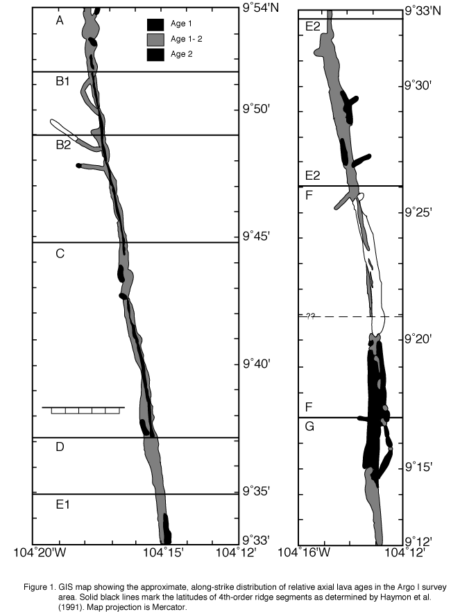
Overlay of vehicle tracklines on any combination of observations was useful for noting gaps or scarcity in data coverage or to test the validity of distributions, particularly in the extreme southern portion of the survey area where density of trackline coverage is least. GIS proximity analysis ("buffering" in GIS terminology) of Argo I video and side-scan sonar observations allowed for the creation of a map which estimates the along-strike extent of three relative ages of lavas (Wright et al., in press) (Figure 1).
The "AdVenture" series of cruises with Alvin have involved detailed, integrated sampling of the features that were discovered and mapped during the Argo I survey (Haymon et al., 1992a and 1992b; Haymon, 1992; Lutz and Fornari, 1992; Haymon et al. 1993). The GIS was used during the 1991 and 1992 AdVenture cruises to manage Alvin navigational and sampling station data, and to optimize the on-bottom time of Alvin as it explored and sampled the hydrothermal vent fields. Alvin observational and navigational data were compiled in the GIS, integrated with the Argo I GIS data layers, and used for the creation of real-time geologic and tectonic maps of the vent areas to be investigated with Alvin. These GIS maps served as "road maps" to the seafloor for the science observers in Alvin and thus greatly reduced the amount of time needed to locate dive targets in dark, murky bottom waters. This subsequently left more time for sampling rocks, hydrothermal vent fluids and deposits, and biota. The positions and attributes of features discovered during the dives, as mapped by the GIS upon the return of Alvin to the surface, were valuable for shipboard decision-making on where subsequent dives should be located.
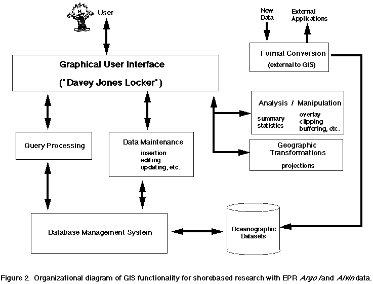
Details regarding GIS data structure and data operations for Argo I and Alvin data are discusses in Wright (1994). Most functions are currently hidden behind a graphical user interface named "Davey Jones Locker" (Wright 1994). Davey Jones Locker currently allows the user to concurrently view Argo I, Alvin, and Sea Beam data from the EPR, 9¹- 10¹N, generate textfile reports of observational data from the GIS database, prepare simple maps of feature distributions, and convert Sea Beam data to GIS format (Figure 2).
Future GIS-related tasks and research related to RIDGE data include the following:
One of the surprising aspects of the introduction of any new technology to a discipline is the way in which it creates new perspectives and methodologies, rather than merely automating the "old way of doing things" (Caswell 1992). Given widespread use, it remains to be seen how GIS will affect data collection, processing, and mapping of oceanographic data, both at sea and on shore.
ReferencesCaswell, D. A., GIS: The "big picture" in underwater search operations, Sea Technology, 33, 40-47, 1992.
Daratech Inc., New GIS market study, GIM: Intl. J. Surv., Map., Appl. GIS, 8, 36-37, 1994.
GIS World, Inc.,1993 International GIS Sourcebook, 771 pp., GIS World Inc., Fort Collins, Colorado, 1993.
Hatcher, G., A Geographic Information System as a Data Management Tool for Seafloor Mapping, Master's Thesis, University of Rhode Island, 1992.
Haymon, R. M., From hot lava to tall spires of "burning rocks:" Initiation and first-year growth of chimneys at new vents on the East Pacific Rise (EPR) at 9Ī45-52'N (abstract), Eos Trans. AGU, 43, 524, 1992.
Haymon, R. M., D. J. Fornari, M. H. Edwards, S. Carbotte, D. Wright, and K. C. Macdonald, Hydrothermal vent distribution along the East Pacific Rise Crest (9Ī09'-54'N) and its relationship to magmatic and tectonic processes on fast-spreading mid-ocean ridges, Earth Planet. Sci. Lett., 104, 513-534, 1991.
Haymon, R., D. Fornari, R. Lutz, M. Perfit, K. Macdonald, K. Von Damm, M. Lilley, W. C. I. Shanks, D. Nelson, M. Edwards, M. Kappus, D. Colodner, D. Wright, D. Scheirer, M. Black, H. Edmonds, E. Olson, and T. Geiselman, Dramatic short-term changes observed during March '92 dives to April '91 eruption site on the East Pacific Rise (EPR) crest, 9Ī45-52'N (abstract), Eos Trans. AGU, 43, 524, 1992a.
Haymon, R., D. Fornari, R. Lutz, K. Von Damm, M. Perfit, M. Lilley, W. C. I. Shanks, K. Macdonald, M. Edwards, D. Nelson, D. Colodner, M. Kappus, D. Wright, M. Black, D. Scheirer, H. Edmonds, E. Olson, and T. Geiselman, 1991 eruption site on the East Pacific Rise at 9Ī45'-52'N is evolving rapidly: Results of AdVenture '92 dive series, RIDGE Events, 3, 1-2, 11, 1992b.
Haymon, R. M., D. J. Fornari, K. L. Von Damm, M. D. Lilley, M. R. Perfit, J. M. Edmond, W. C. Shanks III, R. A. Lutz, J. B. Grebmeier, S. Carbotte, D. Wright, E. McLaughlin, E. Smith, N. Beedle, and E. Olson, Volcanic eruption of the mid-ocean ridge along the East Pacific Rise crest at 9Ī45-52'N: 1. Direct submersible observations of seafloor phenomena associated with an eruption event in April, 1991, Earth Planet. Sci. Lett., 119, 85-101, 1993.
Langran, G., and D. J. Kall, Processing EEZ Data in a marine geographic information system, 1991 EEZ Symposium on Mapping and Research, 127-129, Portland, Oregon, 1991.
Li, R., and N. K. Saxena, Development of an integrated marine geographic information system, Mar. Geod., 16, 293-307, 1993.
Lutz, R. A., and D. J. Fornari, A system for monitoring biologic and geologic changes on a fast-spreading mid-ocean ridge crest (abstract), EOS, Trans. AGU, 73, 278, 1992.
Maguire, D. J., An overview and definition of GIS, in Geographical Information Systems: Principles and Applications, 1, edited by D. J. Maguire, M. F. Goodchild and D. W. Rhind, 9-20, John Wiley and Sons, New York, 1991.
Mason, D. C., M. A. O'Conaill, and S. B. M. Bell, Handling four- dimensional geo-referenced data in environmental GIS, Int. J. Geographical Info. Sys., 8, 191-215, 1994.
RIDGE, RIDGE Science Plan 1993-1997, 101 pp., RIDGE, Woods Hole, Massachusetts, 1993.
Wilcock, W. S. D., D. R. Toomey, G. M. Purdy, and S. C. Solomon, The renavigation of Sea Beam bathymetric data between 9Ī and 10Ī N on the East Pacific Rise, Mar. Geophys. Res., 15, 1-12, 1993.
Wright, D. J., From Pattern to Process on the Deep Ocean Floor: A Geographic Information System Approach, Ph.D. Dissertation, University of California, Santa Barbara, 1994.
Wright, D. J., R. M. Haymon, and D. J. Fornari, Crustal fissuring and its relationship to magmatic and hydrothermal processes on the East Pacific Rise crest (9Ī12'-54'N), J. Geophys. Res.,J. Geophys. Res., 100(B4):6097- 6120, 1995.
Wright, D. J., R. M. Haymon, and K. C. Macdonald, Breaking new ground: Estimates of crack depth along the axial zone of the East Pacific Rise (9Ī12'-54'N), Earth Planet. Sci. Lett., in press, 1995.
Figure 1. GIS map showing the approximate, along-strike distribtuion of relative axial lava ages in the Argo I survey area. Solid black lines mark the latitude of 4th-order ridge segments as determined by Haymon et al. (1991). Map projection is Mercator.
Figure 2. Organizational diagram of GIS functionality for shorebased research with EPR Argo I and Alvin data.