University Consortium for Geographic Information Science
43351 Spinks Ferry Road
Leesburg, Virginia 20176-5631
703-779-7980 (phone), 703-771-1635 (fax)
execdir@ucgis.org
www.ucgis.org
Our Mission
Spring 2001 Headlines
Vol. 3, No. 1
UCGIS HUD Grant Update
- Illinois-Champaign-Urbana, Iowa, Virginia-Commonwealth,
West Virginia, Wisconsin-Milwaukee
UCGIS at the United Nations
UCGIS/USGS Colloquia on GIScience and Vector-Borne
Disease
- Goverment, private sector, academia in successful
collaboration
Transportation and GIS Meetings Proposed
Avoiding Listserv Lunacy
- Tips and reminders for improved emailing
all articles written by Suzy Jampoler,
except where indicated

UCGIS Refines Emerging Themes in GIScience
by Suzy Jampoler and Dawn Wright
The UCGIS Summer Assembly will be held at the University Inn
and Conference Center in Amherst, New York, from June 20-24, 2001, and
hosted by the State University of New York at Buffalo. The
Assembly is one of two annual business and professional meetings of the
50+ member institutions. The Consortium's last meeting was in
Washington, DC, during February 2001, when members also met with
representatives of federal agencies interested in geoscience, with
home state congressional delegations, and with congressional committee
staff members.
A major item on the agenda of the Summer Assembly will be a discussion of
geoscience areas where future research is either necessary to clarify an
issue or now possible because of the advances of technology and the
development of new analytical tools - or both. Consortium members have
proposed and approved seven "emerging themes for research" and refinement
of these topics will be the major work of the Assembly. These seven include:
-
The integration of high volume, aircraft and satellite sensor data into
other, older geospatial data sets to maximize utility. (led by George Hepner,
University of Utah for ASPRS, Bethesda, MD)
- The development of new methods and tools with which to "mine"
geographic data, to discover and to extract useful information in
large, heterogeneous databases. (led by May Yuan, University of Oklahoma,
Norman, OK)
- The definition of categories ("ontologies") of geographic phenomena for
GIS software systems to enhance the accessibility and use of data, and
to order the way in which geographic data are modeled, stored and
manipulated. (led by Max Engenhofer, University of Maine, Orono, ME and
David Mark, The State University of New York, Buffalo)
- The scientific visualization of geographic data to enhance its
understanding and communication. (led by Aileen Buckley, University of Oregon,
Eugene, OR)
- The enrichment of spatial theory (analytical cartography) through the
integration of cartography, mathematics, geography, computer science
and image analysis. (led by Harold Moellering, Ohio State University,
Columbus, OH)
In addition, there will be plenary sessions on distance education and GIScience,
a GIScience model curriculum, and the NSF Research-based Graduate
Education (IGERT) program.
BACK TO TOP
Model Curriculum Development Proceeding
The Model Curriculum Committee is continuing to work on the curriculum development.
The Curriculum Committee will be presenting its work to date at the Summer Assembly this month.
The committee recently prepared a proposal to the National Science Foundation (NSF) to
develop an undergraduate model curriculum in GIScience. This proposal was approved by the
Board of Directors and submitted by UCGIS with Duane Marble (The Ohio State University)
as principal investigator, and Aileen Buckley (University of Oregon) and
Elizabeth
Wentz (Arizona State University) as Co-PIs. This proposal is the first where the PIs will work directly
for UCGIS rather than through sub-awards to member universities. If funded,
the curriculum development will be completed by the PIs with assistance from a large
advisory committee and expert evaluation group.
ESRI has provided a grant to UCGIS to fund meetings of the committee while awaiting
NSF's response. The next meeting of the group will be in San Diego in August.
For more information, contact Duane Marble at
marble.1@osu.edu
BACK TO TOP
Intergraph Young Scholars Program Announced
Intergraph Corporation is sponsoring a new grant opportunity with UCGIS:
The Intergraph Young Scholars Program. This program is designed to give junior
faculty the opportunity to participate in the UCGIS Summer Assembly and Winter Meetings.
All expenses to the UCGIS meeting are paid for the selected applicants.
Three academics have been chosen for the first Intergraph Young Scholars award:
BACK TO TOP
Student Travel Grants and Presentations
One highlight of the UCGIS Summer Assembly will be the presentation
of award-winning research papers by nine graduate students.
Graduate students from GIScience-related disciplines countrywide competed
for a small number of travel grants to attend this summer's UCGIS membership
meeting. The grant winners come from 30 universities throughout the United
States. The students will present their research at a poster session. There
are nine students from among the grant winners whose scholarship was judged
to have exceptional merit. These nine will present a paper on their research
to the full assembly. They include:
- Daikwon Han (SUNY-Buffalo),
"A Space-Time Framework for the Representation of Environmental Health in a GIS"
- Ruihong Huang(University of Wisconsin-Milwaukee,
"Object-Oriented Data Modeling and Trip Planning Algorithms For
Dynamic Transit Networks"
- Krzysztof Kolodziej (Massachusetts Institute of Technology,
"Using the Unified Modelling Language (UML) to Model Distributed GIS Processes"
- Jiyeong Lee (Ohio State University,
"A Spatial Access Oriented Implementation of a Topological Data Model for
3D Geographic Entities"
- Jun Liang (University of Cincinnati),
"Simulating Crimes and Crime Patterns Using Cellular Automata and GIS"
- XiaoHang Liu (University of California at Santa Barbara,
"First Exploration on the Impact of Temporal Resolution on Dynamic Land Use
Change Modeling"
- Jody Lynn Paulson (University of Idaho), "Spatial Predictive Modeling:
A Neural Network Approach"
- John Rogan (San Diego State University, "Estimation, Mapping and Evaluation
of Thematic Change-map Classification Accuracy Using Geostatistical Methods"
- Abigail Vitale (University of Georgia), "Modeling Neo-tropical Bird
Habitat Using Bayesian Statistics and Landscape Variables in a Geographical
Information System"
The full text of most of these student papers may be viewed from
www.geog.buffalo.edu/ucgis/students2001.html.
In addition, the following students presenting posters were funded by the UCGIS to
attend the meeting:
- Sharolyn Anderson, Arizona State University
- TzeeKiu Edwin Chow, U South Carolina
- Z. Asligul Gocmen, University of Michigan
- Ofer Heyman, Oregon State University
- Geoffrey Smith, University of Iowa
- Takashi Tada, Clark University
- Bastiaan van Loenen, University of Maine
- Bing Xu, UC Berkeley
The full text of student papers upon which all student posters are based
may be viewed from
www.geog.buffalo.edu/ucgis/studentposter.html
See also
Degrees of Freedom: Finding Work in Academia
BACK TO TOP
Dr. Barbara Buttenfield Honored as UCGIS Educator of the Year
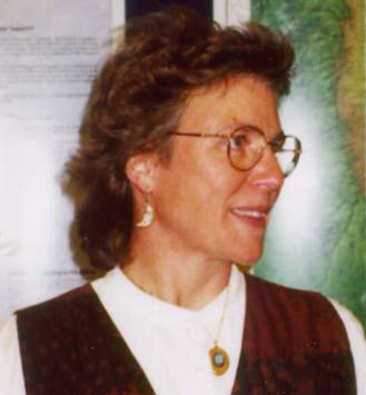
Dr. Barbara Buttenfield will be awarded the first University Consortium for Geographic Information
Science Outstanding GIScience Educator Award at the UCGIS Summer Assembly in Buffalo
this month.
The criteria for selection are a) excellence in teaching GIScience courses, b)
supervision of graduate students entering careers in GIScience education and research,
c) authority of significant publications in GIScience education, d) leadership in GIScience
curriculum development and program design, and e) leadership in the development of
GIScience education policy in academic and professional organizations.�
The selection committee's decision was based on Dr. Buttenfield's numerous contributions to
GIScience education including her:
-
exemplary curriculum development in some of the most prestigious programs in the United States
- substantial participation in the creation and development of major national GIScience programs such as UCGIS and NCGIA
- supervision of some 35 masters students and 7 doctoral students, many of whom are also making significant contributions to GIScience education and research
- outstanding record of jointly authored peer reviewed publications with her graduate students.�
Dr. Buttenfield is a Professor of Geography at the University of Colorado, Boulder.
She received her Ph.D. from the University of Washington in 1984. Dr. Buttenfield's
educational interests are in GIS, Computer Cartography and Scientific Visualization.
Her research focuses on cartographic knowledge formalization and acquisition, spatial
data delivery on the Internet, and on visualization tools for geographic modeling. She
was one of the original co-principal investigators on the NSF-awarded NCGIA
(National Center for Geographic Information and Analysis, and an original co-principal
investigator on the Alexandria Digital Library Project. The University of Colorado at Boulder
is one of the twenty-nine founding members of UCGIS.
Dr. Buttenfield has served on the UCGIS Board of Directors since 1999. She
has been active on the Board in sponsoring student participation in UCGIS activities.
BACK TO TOP
UCGIS HUD Grant Update
UCGIS has awarded five sub-contracts to member institutions to complete work
on the University Consortium for Geographic Information Science grant �Global Urban
Quality Project: An Analysis of Urban Indictors Using Geographic Information Science (GIS)�.
The universities are:
- University of Illinois, Champaign-Urbana, Emily Talen, PI, Faranak Miraftab, Lewis Hopkins,
Zorica Nedovic-Budic, Co-PIs
- University of Iowa, Gerard Rushton, Michael McNulty, PIs
- Virginia Commonwealth University, Robert D. Rugg, Weiping Wu, and John Accordino, PIs
- University of West Virginia, Calvin Masilela, PI, G. Elmes, Ge Lin, D. Weiner, co-PIs
- University of Wisconsin-Milwaukee, William Huxhold, PI, Laxmi Ramasubramanian,
Cheryl Ajirotutu, Jochen Albrecht, co-PIs
A first symposium of all the participating universities was held in February. Each of the universities
presented a synopsis of their research and discussed the focus of their urban indicator work.
The universities are all developing web-based training materials to assist planners in incorporating
spatial analysis and urban indicators to support urban planning. Each is using different indicators.
For example, the University of Iowa is working on health care indicators, University of Illinois on
transportation, University of Wisconsin on housing and population. They are also taking different
approaches.
Some of the universities are working with multiple partners, others with only one or two.
One of Virginia Commonwealth University's partners is the Open Remote Sensing Laboratory
in Shanghai. Part of their focus will be on remotely sensed information. They will be working with
their other partner in Guatemala on natural hazards. West Virginia University is working with
one partner in Mozambique and working on a variety of indices they have identified.
The second symposium will be held in Washington DC, September 26-28, 2001. In
addition to representation from each UCGIS university, one participant from each of the
partnering organizations will be invited. These partners form an advisory committee to the
project to ensure that local concerns and issues are addressed in the data collection and
training materials.
This year's project is a proof-of-concept. UCGIS participating universities are
developing a global network to disseminate the training materials created to support this
project. One of the first tasks for the members of the network will be to establish a quantitative
baseline of data for the partnering cities. The project will also put into place mechanisms for the
systematic collection of the data to monitor change and assist in developing and evaluating
policies and programs to improve housing and living conditions.
For more information, contact Dr. Kenneth Dueker, UCGIS Project Manager at
duekerk@pdx.edu.
BACK TO TOP
UCGIS at the United Nations
As a part of its Global Urban Indicators grant from the US Department of
Housing and Urban Development (HUD), UCGIS is working to build a stronger
relationship with the United Nations HABITAT program. HABITAT is a long-standing
UN program to improve the quality of life for people throughout the world. A global call
to action to provide sustainable human settlements was issued at the HABITAT II
Special Session in Istanbul in 1996. The goal was to provide adequate shelter, a
healthy and safe environment, basic services, and productive and freely chosen
employment for all the world's citizens. The adoption of the HABITAT agenda five years
ago in Istanbul marked a turning point in international efforts to promote socially and
environmentally sustainable cities, rather than a continued focus on rural environments.
Gerry Rushton, Bill Huxhold and Suzy Jampoler joined the HUD Office of Policy
Development and Research (OPD&R) on the US State Department delegation to the
United Nations Istanbul +5 meeting, June 6-8, 2001 in
New York City. This Special Session of the UN General Assembly was called to review
the implementation of the HABITAT agenda. Over 1500 representatives, including heads
of state, attended the meeting.
HUD's OPD&R Division organized a special event discussion on "Global Urban Quality:
An Analysis of Urban Indicators Using Geographic Information Systems (GIS)".
Alven Lam, the HUD Program Manager for the UCGIS HUD grant moderated the session.
Bill Huxhold gave an overview presentation on the importance of micro-level urban indicators
for solving local problems using spatial analysis. He discussed disaggregating data from the
global to local levels. Suzy Jampoler represented the five UCGIS universities currently working
on developing training materials using GI Science with urban indicators to support local
decision-making. She provided an overview of UCGIS and of each university's project.
The projects focus on a variety of applications -- from health care to housing to transportation.
Gerry Rushton followed with a detailed application using health indicators to improve
maternal health care.
Meetings were also held with representatives from HABITAT, including
Guenter Karl, Coordinator of the Global Urban Observatory, Christine Auclair, indicator
specialist, and Nefise Bazoglu, of the UN Secretariat HABITAT office. The
purpose was to find additional partners for on-going research through the
Global Urban Observatory members, discuss how GIS when integrated with
reliable urban indicators is a useful planning tool, and identify additional funding
sources to continue and expand the current research. The delegation also met
HUD Deputy Assistant Secretary Shannon Sorzano.
BACK TO TOP
UCGIS/USGS Colloquia on GIScience and Vector-Borne
Diseases
UCGIS has completed a series of colloquium sponsored by a grant from the
United States Geological Survey (USGS) on GI Science and Vector-Borne Diseases.
A major goal of the meetings was to facilitate the development of a network among
researchers interested in the integration of geographic analysis to understand vector-borne
diseases, such as malaria, dengue, and West Nile virus. GIScientists from UCGIS
member institutions, researchers working on vector-borne disease and participants from
USGS we invited to both meetings.
The first meeting, organized by Art Getis, was held in San Diego in January 2001.
Because the participant base was so multidisciplinary, the first portion of the meeting
included extensive discussions of individual research concerns, and identifying a common
vocabulary. For example, "vector" has a very different meaning to GIScientists than to
epidemiologists. Participants than examined a variety of relevant research topics.
Topics identified included data types, acquisition, integration, and management.
Scale and resolution were identified as major research areas. Participants discussed whether
scientists could agree on a mutually acceptable definition of scale/resolution/level/hierarchy and
appropriate scale ranges for analysis and interpretation. Incorporation of epidemiological
spatial and temporal models was also discussed. Models can�among other things�identify
a major disease process, forecast the future course of a disease outbreak, determine
intervention courses, or measure risk.
The second meeting, organized by Uriel Kitron, was held in Virginia in May 2001.
The colloquium included presentations, interactive demonstrations, and significant time for
individual discussions on future research and collaboration. Presentation topics included
GIS techniques, application of remote sensing and GIS to vector-borne-disease analysis,
and user requirements. The agenda can be found
www.ucgis2.org. Dr. Nancy Maynard from NASA Goddard was the welcoming
dinner speaker.
Two data sets, one on West Nile virus from Steve Guptill and Lee DeCola at USGS
and one on Lyme disease from Uriel Kitron were provided. Participants spent time
exploring a variety of analytical strategies using these data during the interactive sessions.
A CD-ROM containing these data sets is available. Contact Suzy Jampoler
for more information.
The coordinating committee for the two meetings was Art Getis, Uriel Kitron, Gerry Rushton,
Steve Guptill, Lee DeCola and Suzy Jampoler. UCGIS appreciates the support from
USGS to offer these two meetings. These meetings enhance the multidisciplinary nature of
UCGIS, and provide a significant benefit to its members.
The final report on these meetings will be available soon on the UCGIS web site.
A notice to the ALL list will be sent out at that time. If you are not a member of the ALL
list go to www.ucgis.org/f2acontac.html to subscribe.
BACK TO TOP
Transportation and GIS Meetings Proposed
The Bureau of Transportation Statistics (BTS) is the newest UCGIS federal
affiliate member. Each federal member brings a unique and focused research
interest to UCGIS. UCGIS is working on a proposal to host three symposia on
GIScience and Transportation in the next year. These meetings are expected to
focus on all aspects of transportation, and bring together transportation professionals
from the federal, state and local levels, academics interested in research topics in
GIScience and transportation and network analysis, and private industry. Planning
for these meetings is in the preliminary stages. For more information, contact
Suzy Jampoler.
BACK TO TOP
Avoiding Listserv Lunacy
by Dawn Wright
Over the past year UCGIS has had good success with a new listserv software
called Lyris which features automatic error mail handling, multiple
level security, and failsafe unsubscribing that prevents those annoying
"get me off this list!" messages. It also has an easier, web-based
interface for subscribers and adminstrators. Below are a few listserv
reminders and/or tips to ensure a pleasant UCGIS emailing experience:
- Remember that a listserv allows you not only to receive messages
as part of your subscription but to send them to all others subscribers
as well. There is no need to ask someone to forward them for you - you
already have the power!

- Many people refer to UCGIS email transactions as coming from "the list."
UCGIS actually has 12 different UCGIS mailing lists for various
levels of communication. They include:
- all@ucgis.org
- board@ucgis.org
- chairs@ucgis.org
- lead-delegate@ucgis.org
- delegates @ucgis.org
- members@ucgis.org
These are described at www.ucgis.org/faddresses.html.
There are over 450 people subscribed to "all@ucgis.org" but the majority
of them are subscribed to at least 1 or 2 other listservs. For example,
the typical UCGIS delegate is subscribed to "all", "delegates", AND
"members."
- Because we have hundreds of people subscribed to our lists, the UCGIS
community is strongly encouraged to take advantage of the "self-serve"
options available via our Lyris listserv software. The easiest way to
do this is begin at
www.ucgis.org/f2acontac.html and click on the link that says "View,
subscribe, or unsubscribe from email listservs via the Web". No password
is required, only your primary email address.
- Please remember that Lyris and other kinds of listserv software identify
you by your email address, so when attempting to post messages to a UCGIS
list you must always use the same email account that matches your subscriptions.
And once again, it is likely that you have more than 1 subscription.
BACK TO TOP
The University Consortium for Geographic Information Science (UCGIS) is a
non-profit association of universities and other research institutions.
The mission of UCGIS is:
- to serve as a unified and effective voice for the geographic information
science community;
- to foster multidisciplinary research and education in geographic
information science; and
- to promote the informed and responsible use of geographic information for
the benefit of society.
Last updated: June 18, 2001.
Challenges is an occasional publication of the UCGIS.
For submissions, corrections, comments or questions, please contact
Dawn Wright,
dawn@dusk.geo.orst.edu.