
9(3): 22, 24-26, 1999.
© Copyright reserved by Dawn Wright
and ADVANSTAR Communications.
May be freely distributed electronically in whole or in part,
but please keep this notice attached and do not alter the text.
May be freely distributed electronically in whole or in part,
but please keep this notice attached and do not alter the text.
"Distance learning" has now become a familiar term on university campuses nationwide. Several corporations and associations, to help meet the challenges of the information explosion in industry, are also adopting it (e.g., the American Society of Association Executives). The vast potential of distance learning, defined by Nelson (1997) as that which "makes learning independent of time and place and available throughout a learner’s lifetime", is certainly not lost on the GIS community. As the clamor for training and education in GIS grows louder so to will the demand for effective modes of instructional delivery to users, regardless of time, place, or, in some cases, educational background. Instructors in GIS are also beginning to realize what is unique about teaching GIS: the technological orientation of the subject, the head- spinning evolution of that technology, the need for collaboration not only for creative innovation in the classroom but merely to keep up (not faced by instructors in fields such as English where the fundamentals of Shakespeare and other subjects are firmly entrenched), and the realization that many institutions of higher education are not yet equipped to support these instructional requirements (Kemp, 1998). The University Consortium for Geographic Information Science (UCGIS) has long been concerned with these issues, as well as with the broader expansion and improvement of GIS education and the important role that research institutions must play in the community of GIS educators (Kemp and Wright, 1997). One of the "action items" finalized in late 1997 by the UCGIS Education Committee was the reconvening of a "virtual seminar" in geographic information science. UCGIS, by virtue of its research focus on both theoretical and applied GIS and related technologies, is well placed to play a major role in testing and advancing new educational technologies (Wright et al., 1997).
CYBERSPACE CLASSROOM
A virtual seminar is simply an educational seminar that is held outside of a traditional classroom. As such it can be an effective instructional tool for teaching students who are at great distances from their instructor(s). Unlike conventional classroom teaching, a virtual seminar requires the implementation of what are now considered to be "emerging technologies" for education (Wright et al., 1997): the Internet or Internet 2, intranets, Web conferencing software, video conferencing via television (e.g., PictureTel®), real- time video over the Internet (e.g., CuSeeMe® or Vxtreme®), or multi-media CD-ROMs. Cyberspace has become the most popular venue. A virtual seminar is useful for both individualized instruction, in which the participant is both learner and mentor, and group instruction, where an administrator controls the technical and logistical details of the seminar and removes barriers between learners and instructors (Nelson, 1997). Not only does it create an electronic learning community of sorts but experience has shown that the circulation of time- sensitive information is more efficient via a virtual seminar, as well as for technology transfer because of the one-to-many mentoring that helps participants solve problems as they occur (Nelson, 1997).
The UCGIS, in recognition of the potential of a virtual seminar for expanding the scope and quality of GIS education, decided to experiment with one in the winter of the 1996-'97 academic year. Ten member institutions (SUNY- Buffalo, Clark, Colorado, Georgia, Hunter College-CUNY, Ohio State, San Diego State, UCSB, Washington, and West Virginia) participated in this first effort, using the Motet™ conferencing software to communicate over the web (Motet was chosen because it was already installed and operational for other activities at UCSB, the host institution for the seminar). The graduate-level seminar focused discussion on all ten of the cutting-edge Research Challenges set by the UCGIS at its strategic meeting in the summer of 1996 (Web URL: http://www.ucgis.org). Students and faculty met both in the classroom and over the web to critique and discuss the white papers on the Research Challenges. Many participants also wrote term papers with positional statements and posted them online. Classroom discussions were stimulating but the real challenge came, of course, in the online settings where a "discussion" can take on a different dimension, as ably described by Williams (1997):
"It’s a very human activity, that’s for sure. The words can have an incandescent feeling, brighter and larger than life. The interactions can have heightened emotional or creative charges, despite the fact that we may never see one another face to face. Taking part in a conversation in text, distributed to its participants by means of networked computers, is a relatively new group experience. It’s just familiar enough to feel like there’s nothing to it, and just foreign enough to feel like the birthplace of a new kind of human community. Like actors on a bare stage, members of a[n online] discussion create the illusion of a place, a scene you can watch or join, by their words and perhaps simple graphical gestures."
Critiques of the first seminar included the unweildiness of trying to cover ten topics moderated by ten leaders with students on both the semester and quarter systems, lack of coordination among leaders, unfocused, sometimes fragmented discussions online, and difficulties with the software. However, it did provide a unique opportunity for students and faculty to trade and test ideas in near real-time with colleagues nationwide, thereby gaining broader views on "hot" theoretical questions, fresher perspectives and exposure to different academic backgrounds. Students were given opportunities to do or prepare research in areas that would not necessarily be a strength on their own campuses. This occurred via interaction with the well-known GIS scholars at the participating institutions who moderated all discussions. The first seminar was therefore deemed an overall success and there was general enthusiasm (as in the aforementioned UCGIS action item) for a second effort, hosted by a different UCGIS institution, and incorporating the suggestions for improvement from the first course.
During the fall term of 1998, a second virtual seminar was held among five institutions of the UCGIS and focused on five of the UCGIS Research Challenges:
The software chosen for the seminar was Allaire Forums (Web URL: http://www.allaire com) a popular, Windows NT-based, web conferencing software with a capability for threaded discussion that Motet lacked. Forums ran on top of Cold Fusion Studio 3.1 (for database and archiving purposes) on a dedicated NT server provided by Oregon State.
Thirty-five students were officially registered for graduate credit on the five campuses, and there were an additional 35 people nationwide who logged in at various times in order to observe the discussions. Registered students were expected to read and critique the UCGIS "white papers" for the topics, to expand their reading for selected themes, to contribute to the online discussion forums, and to participate in classroom discussions. Structuring of the classroom component of the seminar varied on different campuses: for some the virtual seminar was a 1-credit course in itself, and for others it was part of a larger 3-credit course. Some students made their final terms papers available online, and one student used the virtual seminar to conduct dissertation research (via a survey) on GIS and ethics.
STUDENTS SPEAK OUT
An added dimension of the course was the convening of a panel session at GIS/LIS ‘98 in Fort Worth, Texas. The panel was comprised of participating students from Louisiana State, Oregon State, and the University of Minnesota in order to:
A summary of the GIS/LIS ‘98 panel discussion in terms of the seminar’s pros and cons as expressed mainly by the students appears in Table 1. Figure 1 shows the results of an informal survey of registered students during both the 1997 and 1998 virtual seminars. A significant result is that more learning occurred for the students locally on their own campuses. Overall, most of the students gave the seminars a positive evaluation and would participate in a similar course again.
Table 1: Student evaluation of 1998 UCGIS virtual seminar from GIS/LIS Panel Discussion
|
Pros |
Cons |
|
Exposure to students from different campuses, interaction nationwide |
Topics broad and advanced; more specific examples needed to illustrate concepts |
|
Access to "experts", literature, broader knowledge base |
Needed more background reading, professors to focus discussions more |
|
Better sense of evolution of GIS field, introduction to GIScience as well |
|
|
Better sense of how students can contribute to UCGIS and geographic information science in general |
|
|
Learned more than just reading the literature |
Pace of discussion sometimes overwhelming in web environment (catching up on postings) |
|
Time to formulate and re-edit intelligent questions & replies before actual posting |
Intimidation factor on the web, easier to "speak up" in face-to-face meetings |
|
Interaction at any time of day or night (great for working students) |
Students on semesters had greater momentum overall on a weekly basis |
|
Allaire Forums was fairly simple and easy to quickly get used to |
Printouts from Allaire pages cumulative, couldn't select by "day" and print only those |
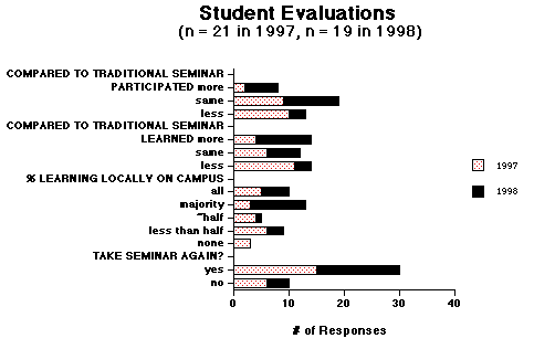
Figure 1. Student evaluations of 1997 and 1998 UCGIS
virtual seminars from email surveys. 1998 responses
"stacked" to the right of 1997 responses.
LESSONS LEARNED; FUTURE DIRECTIONS
It is still too soon to predict whether virtual seminars will be the future of GIS education or just another "flash in the pan," but the prognosis for their utility is very good. The UCGIS seminars have helped to develop some of the goals and priorities of the organization, and the intellectual stimulation and feedback that is illicited appear to be worth keeping it alive. An important lesson learned from the UCGIS "experiments" is that merely trying to replicate a traditional academic session in a non-traditional, virtual format may be selling the technology short. For instance, virtual seminars have great potential for engaging interaction with worldwide experts who would otherwise never be able to participate (e.g., real-time online chats or videoconferencing with a "guest speaker" from India, Australia, etc.). And there should be many opportunities in the future for actually running GIS packages online while a seminar is in session or experimenting with developmental source code and algorithms.
The following suggestions for future UCGIS virtual seminars may be of help to readers who are seriously considering the use of this kind of distance education on a university campus or within the GIS industry.
The 1998 UCGIS virtual seminar may be reached from the UCGIS web site or directly at Web URL: http://dusk.geo.orst.edu/virtual, from which archives of the discussions and term papers may be downloaded.
REFERENCES
Kemp, K. 1998. Interoperability for GIScience education. GIS/LIS ’98 Proceedings, Fort Worth, Texas, Session 18.
Kemp, K., and R. Wright. 1997. UCGIS identifies GIScience education priorities. Geo Info Systems 7(9): 16-18, 20.
Nelson, H. R., Jr. 1997. Virtual seminars. Computers and Geosciences 23(5): 601-606.
Williams, G.A., 1997. Online moderator guidelines and community-building tips: freenet.msp.mn.us.
Wright, D., G. Elmes, K. Foote, J. Chen, N. Faust, B. Savitsky, and J. Sewash, Emerging technologies for delivering GIScience education. University Consortium for Geographic Information Science Education Priority White Paper, http://www.ncgia.ucsb.edu/other/ucgis/ ed_priorities.
Dawn Wright is an assistant professor of geosciences at Oregon State University. She is also a member of the UCGIS Education Committee and chair of the UCGIS Communications Committee. Her email address is dawn@dusk.geo.orst.edu and her World Wide Web site is URL: http://dusk.geo.orst.edu.
 Return From Whence You Came! Return From Whence You Came! |