
Page 27 - GIS for Science: Technology Showcase
P. 27
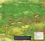
  LEGEND
Anthropogenic deposit Peat
Clay
Sandy clay and clayey sand Fine sand Medium-grained sand
Coarse sand Gravel
      TNO, an independent Dutch research agency, shares massive 3D datasets freely online. The data shown here represent TNO’s GeoTOP, a detailed 3D model of the top 30 meters of soils beneath the surface of the Netherlands. This scene was created with ArcGIS Pro. The data are displayed aboveground at 50 times vertical exaggeration.
