
:: Summary PowerPoint File ::
:: Written Report ::
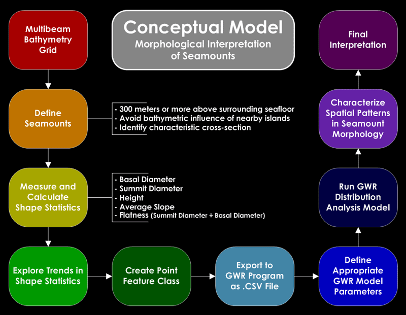
This project serves as pilot study for what is intended to develop into a comprehensive thesis study. The purpose of the larger study (see written report) is to construe the dominant mechanism for seamount genesis in the Eastern Samoan volcanic province employing geographic techniques applied to a high resolution deep sea multibeam bathymetry dataset. A stepwise approach toward this end will include four principal objectives; (1) a compilation of disparate multibeam bathymetry datasets into one contiguous dataset, (2) production of maps and three-dimensional visualizations of the study area for preliminary inspection, (3) statistical analysis of seamount shape and distribution, and finally (4) the inference of probable seamount genesis using shape and distribution analyses in collaboration with relevant petrological and geochemical data. The reduced scope of this pilot study applies only the three latter objectives to a single multibeam bathymetry dataset of the Tutuila flanks, located in the central western portion of the volcanic province. This marks an important first step toward a synoptic geographic analysis of deep sea morphology in the Eastern Samoan volcanic province has never been undertaken and aims to accompany a burgeoning collection of academic investigations using multibeam sonar technology to characterize seamount morphology.
Fotheringham, A. S., Charlton, M. E., and Brunsdon C. 1998. Geographically weighted regression: a natural evolution of the expansion method for spatial data analysis. Environment and Planning A. 30: 1905-27.
Fotheringham, A. S., Charlton, M. E., and Brunsdon C. 2003. GWR 3.0: Software for geographically weighted regression. GWR 3 Manual.
Smith, D. K. 1988. Shape analysis of Pacific seamounts. Earth and Planetary Science Letters. 90: 457-66.