6(1): 22-29, 1996.
PC Arc/Info and ArcView aboard the deepsea research vessel Atlantis II helped oceanographers manage and interpret data gathered by the Alvin submersible (famous for its 1986 exploration of the Titanic wreck) as it explored a seafloor spreading center off the coast of Oregon and Washington.
The integration of multidisciplinary data gathered from multiple sampling platforms for analysis and interpretation is of great importance in oceanography, where geologists, chemists, biologists and physicists often work together in order to "unravel the mysteries of the deep." The cost of acquiring the data alone (e.g., an oceanographic research vessel usually costs over $15,000 a day to operate) justifies the development of dedicated systems for the integration of these data. The synergy of different types of data provides the scientific community and policy decision-makers with more information and insight than that obtained by considering each type of data separately. Here GIS, which provides an essential technology for data dissemination, sharing, cataloguing, archiving, display, and mapping, has an obvious relevance. But despite the great potential of GIS technology for oceanographic applications, its penetration into the field remains modest. This is due in part to: (1) lack of awareness of the potential of the technology; (2) the expense in achieving full operational GIS usage; and (3) lack of a three-dimensional display/analysis capability. Fortunately, the situation is improving. Integrated coastal zone management is now an established and internationally-recognized socio-economic necessity, and GIS tools and methodologies for achieving the relevant goals are currently being used or are under development (e.g., Bartlett 1993 and references therein). In the field of deepsea oceanography, GIS applications are also under development but at a much slower pace.
This article describes the pioneering use of a GIS aboard a deepsea oceanographic research vessel, in concert with the Alvin diving submersible, to explore and map sites along a seafloor spreading center in the Northeast Pacific Ocean. Alvin was used to carry out extensive, integrated sampling of features that were discovered and mapped on previous expeditions to the study area. The use of Arc/Info¨ and ArcView¨ played a major role in optimizing the limited time spent on bottom with Alvin by providing detailed and accurate pre-dive maps of important hydrothermal and geological features for all the proposed dive areas. GIS operations were also valuable post-dive in providing maps of dive tracklines and sample locations in relation to geological features, and in assessing their navigational accuracy. This unique application of GIS had only been accomplished previously on three expeditions to an equatorial segment of the East Pacific Rise in 1989, 1991, and 1992 (Wright 1994, Wright et al. 1995), but only with PC Arc/Info¨, not with ArcView¨.
In June/July of 1995 a scientific party of eighteen, led by Dr. Robert Embley of the Pacific Marine Environmental Laboratory, National Oceanic and Atmospheric Administration (NOAA), made twelve dives to ~1.5 miles depth at selected sites along the Juan de Fuca Ridge (Figure 1). The Alvin submersible is supported by the research vessel Atlantis II for this purpose (Figure 2). Alvin is a Navy-owned vehicle supported jointly by the National Science Foundation, the Office of Naval Research, and NOAA, and operated by the Woods Hole Oceanographic Institution (Woods Hole, MA). The 25-foot-long vehicle typically dives for 8 hours (~6 hours on the bottom), and carries 1 pilot and 2 scientists. It is equipped with remotely controlled mechanical arms and associated sampling equipment, underwater cameras and associated strobe and incandescent lights, a data logging system, water temperature monitors, a precision depth indicator, and a Mesotech sonar bathymetric mapping system. Outside of the oceanographic community Alvin is probably best known for its 1986 exploration of the wreck of the Titanic (Ballard 1987). The Juan de Fuca Ridge that was visited by Alvin lies ~300 miles off the coast of Oregon and Washington (Figure 1) and is actively spreading at a rate of approximately 6 cm/yr (Johnson 1989). In June of 1993, the Sound Surveillance System of the U.S. Navy, consisting of underwater microphones (hydrophones) moored to the seafloor and connected to shore by undersea communication cables (see Fox et al. 1994), detected a swarm of earthquakes on what is now called the CoAxial segment of the ridge (Figure 1 and Figure 3). Once a response team of research vessels, surveying instruments, and remotely- operated vehicles (ROVs) was dispatched to the site, it was confirmed that a volcanic eruption had taken place. Since a deepsea volcanic eruption has yet to be directly recorded from its inception, this discovery excited not only the oceanographic community, but attracted national media attention as well. The geological, chemical, and biological effects of the eruption have since been monitored by two Alvin dive series, one in October 1993 and the other in July 1994. The purpose of the '95 dive series was to gather additional information about the composition of fluids and gases emanating from the hot springs on the segment, and to sample the hotspring mineral deposits, biota, and surrounding basaltic rocks there and at additional segments to the south. Scientists also hoped to deploy a probe for measuring ambient water temperature on the seafloor, as well as recover various instruments that had been gathering data over the past 1-2 years.
Recent discoveries of volcanic eruptions on the seafloor (see Embley et al. 1995 and Haymon et al. 1993) have presented the oceanographic community with a unique opportunity to track the temporal development of seafloor-spreading center hydrothermal systems and the succession of associated fauna after the volcanic system has been "reset" by an eruption. These geological time series observations are occurring on the scales of years to decades. The ability to handle time-dependent data is especially important for modelling such a highly dynamic marine environment. This has provided yet another impetus for input of the oceanographic data into a GIS, where feature distributions from one year can be quickly and easily overlain on distributions from the next or the previous year for interpretation.
PC Arc/Info¨ v. 3.4.2 and ArcView¨ v. 2.1 were installed on an EPS Technologies 486/66 PC, running Microsoft Windows¨ v. 3.1 with 16 Mb RAM and 2 hard disks at ~200 Mb and ~1 Gb capacity. ArcView¨ v. 2.1 was also installed on a Power Macintosh 7100/66 running System 7.1.2 with 33 Mb of RAM and 2 hard disks at ~350 Mb and ~260 Mb capacity. Both machines were networked to the ship's Sun SparcstationŞ 5 for the transfer of various data, as well as to an Apple LaserWriterŞ Select 360 black and white printer, a Hewlett-Packard LaserJet¨ 4 black and white printer, and a Hewlett-Packard 1200C color printer. This flexible setup (Figure 4) allowed for two options: (a) two GIS specialists were able to work simultaneously on data processing and map output for increased work productivity; or (b) one GIS specialist could continue with data processing/map production while the other machine was free for the other specialist to provide GIS demonstrations to the scientific party or allow the scientists to experiment on their own with ArcView¨ 2.1.
Geographically referenced spatial operations are absolutely essential in most oceanographic applications, as navigation is such a crucial factor when land is out of sight. The potential to coregister, geo-reference and analyze the data (particularly sampling stations) within a common spatial reference system was one of our goals in using a GIS at sea. Co-registration between features in an oceanographic application of GIS is, to some extent, quite different from a land-based application. For example, it is very difficult to find control points with known coordinates on the seafloor (there are no street intersections or building corners there yet!). The exception to this is the acoustic transponder, which is an instrument deployed on the seafloor that, upon receiving a designated signal, emits an acoustic signal of its own. The travel time of the signal is used to calculate the distance from the transponder to underwater vehicles such as the Alvin submersible. The primary geometric control for processing spatial oceanographic data acquired by a research vessel is based on navigation data derived from the Global Positioning System (GPS). These navigation data provide the location of a research vessel in latitude and longitude, from which it is possible to derive the latitude/longitude locations of vehicles and instruments towed or launched by the vessels. In oceanography, bathymetric data (i.e., depths to the seafloor) collected from a swath mapping system located underneath a ship may be georeferenced to underwater video images or sidescan sonar data (i.e., images acquired by measuring the strength of a reflected sonar signal from the seafloor) collected from a vehicle towed behind the ship and several meters above the seafloor, to samples sites, observations, temperature measurements, etc. collected from a submersible launched away from the ship and operating directly on the seafloor. This is a very multiscalar mapping problem. For instance, the aforementioned bathymetric data are usually collected at a swath width of ~6-9 km, sidescan sonar data from a towed vehicle may be collected over a swath ~300 m wide, and submersible data may be collected on m to cm scales.
Clearly good navigation was the key to successful tracking of Alvin with Arc/Info¨ and ArcView¨ during the June '95 expedition. This is always a challenge when one considers that the task at hand is to track a small submarine 1.5 miles below the surface as it weaves in and out of an obstacle course of lava pillars and hydrothermal sulfide edifices on the seafloor. The navigation employed was acoustical in nature, because electromagnetic energy normally used for tracking objects through the atmosphere does not travel well through water. Acoustic devices attached to the ship and submarine measure the time it takes a sound pulse to travel to the acoustic transponders moored on the seafloor. If the positions of the ship and the moored transponders are known, as well as the average speed of sound in water, then the submarine position can be found. An instrument on board the ship controls the frequencies used by the ship's transducer and the timing of the sound pulses, and then records the exact time between signals and their replies. In this way a travel time is established between the ship and a transponder which can then be turned into an x, y, z position. Positions of the sub are tracked throughout the dive by navigational computers aboard the ship. These relative x,y,z positions (distances in meters from the established "origin" of the network of transponders on the seafloor) are processed to remove erroneous fixes and then converted into latitude/longitude positions for input to the GIS.
The GIS database already included geographic coordinates and attributes of the following:
Also included were bathymetric contours and images of the Sea Beam swath mapping system (highest resolution contour interval is 5-10 m), contours of Alvin's Mesotech mapping system (highest resolution contour interval is ~1 m), acoustic images from a sidescan sonar system, and various pre-made grids covering selected dive sites in latitude/longitude, UTM, and relative x/y coordinates based on the origin of specific transponder networks for tracking Alvin on the seafloor (Figure 5). The Alvin observational and navigational data from the '95 expedition were reformatted for GIS inputs using various combinations of Unix and Avenue scripts, integrated with the existing Arc/Info coverages, and used for the shipboard creation of real-time geologic and tectonic maps of the vent areas to be investigated (Figure 6). Shipboard GIS operations were easily performed by 2 GIS specialists and were useful to the scientific party in many ways, including the following.
The maps enabled the scientists to better visualize a proposed dive area. For example, geologists could easily pick out bathymetric features such as large fault scarps, fissures, or mounds to shoot for as dive targets (their proposed "landmarks" on the seafloor), especially when these were combined with the locations of seafloor markers or instrument moorings. Seafloor hazardry became an issue on some occasions when it was surmised that a mooring that was scheduled to be recovered may have drifted into a dangerous area, based on the surrounding geology. For the biologists and chemists, the ability to view the geological setting of an area in map form, in addition to viewing videotapes of previous dives to the area, gave them a much better feel for the areas that they were going to be sampling and the distances that they were going to have to travel in order to get to the various sites. A GIS layer of grids based on relative x/y distances from the origin of a transponder network, provided the scientists with these distances and with the specific x/y coordinates of sites to be targeted during a dive. An Alvin pilot uses these x/y pairs, not latitude/longitude, when navigating the sub on the seafloor.
One of the most exciting developments on the expedition for the GIS specialists (and perhaps for the scientists themselves) was to witness many of the scientists (most of whom had no prior experience with GIS) become comfortable enough with ArcView¨ over the course of the 2-week cruise to compose their own views, layouts, and then entire projects. This would probably not have been possible with Arc/Info¨ due to its complexity. A few scientists were able to plan their own dives in this manner and thus gain not only an improved spatial assessment of their proposed dive areas but a better understanding of GIS. An added plus was that this arrangement reduced the workload of the GIS specialists!
On occasion scientists were able not only to get a general feel for the regional setting of an area, they were also able to use the graphics tools in ArcView¨ to lay down specific dive tracks. This was most useful for planning survey lines for Alvin's Mesotech bathymetric mapping system . Scientists in the sub could then inform the pilot of the best course and heading so not to duplicate areas already mapped on previous surveys (Figure 7).
Within Alvin GIS plots often served as "road maps" to the seafloor for the science observers, and on some occasions greatly reduced the amount of time needed to locate dive targets in dark bottom waters. This subsequently left more time for sampling rocks, hydrothermal vent fluids and deposits, and biota. Time is of the utmost premium on the bottom due to the limited battery life of the submersible.
The trackline of Alvin as it traversed the seafloor, as mapped by the GIS in concert with other data upon the return of the sub to the surface, was valuable for shipboard decision-making on how much had really been accomplished on the seafloor and where subsequent dives should be located (Figure 6 and Figure 7). On past Alvin expeditions, tracklines were either: (1) unavailable at sea; or (2) if available not ready until several days after a dive; or (3) if available within hours of a dive not comparable to any other data sets without excessive amounts of data conversion or mylar for light table overlays. With a shipboard GIS, scientists were finally able to efficiently compare the trackline from their dive with the map of the original dive plan, as well as with previous vehicle tracklines and sample stations in the region within hours of a dive's completion. Such a capability is certainly an asset when one is trying to make the most of a 12-dive series with only 14 days at sea on a research ship that costs ~$15,000 per day to operate. The GIS database also held information on the exact locations (to within 5-10 m) of the hydrothermal vents that were sampled on a dive and the types of samples recovered (i.e., rock, biota, or water samples). This helped to avoid confusion as to whether or not to return to a particular vent to recover a certain kind of sample.
GIS operations were also useful for assessing navigational accuracy. Overlays of a 1995 dive track on bathymetry and vent locations from 1994 or earlier yielded a quick assessment of the navigational error in the track. For example, some maps showed tracklines that were offset 10- 30 m in x or y from known vent site on a map, even though the observers had indeed visited a vent site with the associated seafloor marker (landmark). The dive navigation could then be further corrected, resulting in a finalized dive track.
During the '95 Alvin expedition GIS provided interactive data processing support by way of four major categories of functionality (data input/capture, data storage/management, data manipulation, data analysis, and data output/display). With fieldwork these functions often need to occur in rapid succession, which, in an oceanographic context, is particularly the case for scientific operations at sea where the ability to interpret data on a daily basis (instead of having to wait until one gets back to a shorebased lab) can greatly influence logistical decision-making and/or formulation of scientific hypotheses. The ability to quickly establish correlations, proximities, and coincidences for subsequent interpretation between diverse data sets was extremely useful.
One challenge that was not faced on the '95 expedition was the development of appropriate metadata (information about data). This is an important issue as the Juan de Fuca Ridge is visited on a yearly basis by Alvin and other deepsea vehicles for time-series measurements. Such a state-of-the-art "visual presence" on the seafloor often results in the acquisition of data that quickly overcomes the speed at which the data can be interpreted. The paradox is that as the amount of potentially useful and important data grows, it becomes increasingly difficult to know what data exist, how the data were collected and processed, where the data are currently located, and how the data can be accessed. In striving to manage this ever-increasing amount of data and to facilitate their effective and efficient use, metadata becomes an important, almost urgent issue. The GIS component of the VENTS group at the NOAA Pacific Marine Environmental Lab hopes to implement a metadata schema for both shipboard and shorebased GIS operations by mid-1996.
One of the surprising aspects of the introduction of any new technology to a discipline is the way in which it creates new perspectives and methodologies, rather than merely automating the "old way of doing things" (Caswell 1992). Given more widespread use with the oceanographic community, it remains to be seen how GIS will affect data collection and processing methodologies at sea and on shore. The 1995 Juan de Fuca Ridge dive series methodology has certainly been affected in a positive way. As a result scientists were better able to visualize dive areas before going to the seafloor and were better able to reconstruct their activities and make scientific assessments after their dive was completed. GIS operations were so successful in June and July that plans are in effect to use a similar arrangement for another expedition to the Juan de Fuca Ridge in August/September '95. The setup will largely involve ArcView¨ 2.1 (for the Macintosh) and employ AvenueŞ scripts for more efficient input of the data. Based on the success of the '95 expeditions, and given the funding and logistical feasibility, it is hoped that GIS operations will someday become a standard component of oceanographic research with Alvin.
Thanks to Andra Bobbitt of the Cooperative Institute for Marine Resource Studies, Pacific Marine Environmental Laboratory, Newport, OR for helpful comments which significantly improved the manuscript.
Ballard, R. D. 1987. The Discovery of the Titanic. New York: Warner Books.
Bartlett, D. J. 1993. GIS and the Coastal Zone: An Annotated Bibliography. Technical Report, 93-9, National Center for Geographic Information and Analysis.
Caswell, D. A. 1992. GIS: The "big picture" in underwater search operations. Sea Technology 33(2):40-47.
Embley, R. W, W. W. Chadwick, Jr., I. R. Jonasson, D. A. Butterfield, and E. T. Baker 1995. Initial results of the rapid response to the 1993 CoAxial event: Relationships between hydrothermal and volcanic processes. Geophysical Research Letters, 22(2):143-146.
Fox, C. G., R. P. Dziak, H. Matsumoto, and A. E. Schreiner 1994. Potential for monitoring low-level seismicity on the Juan de Fuca Ridge using military hydrophone arrays. Marine Technology Society Journal 27(4):22-29.
Haymon, R. M., D. J. Fornari, K. L. Von Damm, M. D. Lilley, M. R. Perfit, J. M. Edmond, W. C. Shanks III, R. A. Lutz, J. B. Grebmeier, S. Carbotte, D. Wright, E. McLaughlin, E. Smith, N. Beedle, and E. Olson 1993. Volcanic eruption of the mid-ocean ridge along the East Pacific Rise crest at 9ˇ45-52'N: 1. Direct submersible observations of seafloor phenomena associated with an eruption event in April, 1991. Earth and Planetary Science Letters 119:85-101.
Johnson, H. P., and M. L. Holmes 1989. Evolution in plate tectonics: The Juan de Fuca Ridge. In The Geology of North America: The Eastern Pacific Ocean and Hawaii, ed. Winterer, E. L., D. M. Hussong and R. W. Decker, vol. N, pp. 73-91. Boulder, Colorado: Geological Society of America.
Wright, D. J. 1994. From Pattern to Process on the Deep Ocean Floor: A Geographic Information System Approach. Ph.D. dissertation, University of California, Santa Barbara.
Wright, D. J., R. M. Haymon, and D. J. Fornari 1995. Crustal fissuring and its relationship to magmatic and hydrothermal processes on the East Pacific Rise crest (9ˇ12'-54'N). Journal of Geophysical Research , 100(B4):6097-6120.
Figure 1. Map of the Juan de Fuca Ridge in the NE Pacific Ocean.
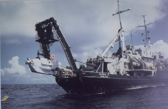
Figure 2. Photo of the R/V Atlantis II, the 210-foot-long mother ship and tender of the Alvin submersible, pictured on the left during a deployment from the "A-frame" on the ship's stern.
Figure 3. Three-dimensional relief image of the CoAxial segment of the central Juan de Fuca Ridge, sight of a volcanic eruption in June 1993, and one of the study areas described in the text. Bathymetry is based on NOAA Sea Beam data. Image generated by Chris Keeley, formerly of the Lamont- Doherty Earth Observatory, Columbia University.
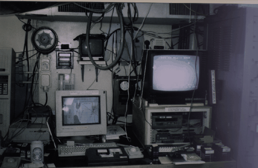
Figure 4. Photo of GIS laboratory installed aboard the Atlantis II for the 1995 Alvin expedition.
Figure 5. Screen dump of a demo ArcView project showing some of the data sets that were available to shipboard scientists during the expedition. Windows clockwise from top left: (a) Sea Beam bathymetry at 50-m contour interval overlain with locations of seafloor markers and rock core sample sites; (b) shaded grid of Sea Beam bathymetry overlain by 1993 earthquake swarms that are described in the text; (c) NOAA logo; (d) Mesotech bathymetry at 1-m contour interval overlain with vehicle tracklines and hydrothermal vent locations; (e) acoustic imagery of an underwater volcano from a sidescan sonar system.
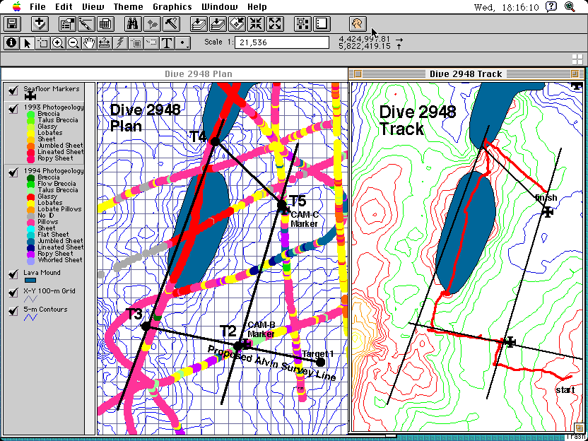
Figure 6. Pre- and post-dive GIS maps for Dive 2948 of the '95 Alvin expedition. Map on the left was prepared before the dive and shows the locations of proposed dive targets (solid black circles) and proposed survey lines for the sub to follow (dark black lines). Also included are Sea Beam bathymetric contours in blue, digitized outlines of lava mounds in grayish blue, and various geological observations that were collected along previous camera tows in multiple colors. Coordinates of the overlain grid are in the relative x/y's of the transponder network for Alvin so that pilot and observers could move directly to a target (Alvin is not navigated in a latitude/longitude frame of reference on the seafloor). Map on the right was prepared after the dive and primarily shows how well the dive track correlates with the pre-dive plan in terms of targets that were reached.
Figure 7. Post-dive GIS map for Dives 2941 and 2944 of the '95 Alvin
expedition. Colored contours are from Mesotech bathymetric data that
were collected in the region in 1994. One of the objectives of Dive 2944
was to gather additional swaths of Mesotech data from the area. The
trackline shows how successfully this was accomplished. Tracklines of
both dives show that proposed sampling and instrument recovery sites
were also visited.
 Return to Dawn's home page