Background
GIS stands for geographic information systems - a system
of hardware, software, data, people, organizations, and standards for
collecting, storing, analyzing, and disseminating information about areas of
the Earth. In simpler terms, the
results of using GIS are usually maps that enable users to better understand
and analyze data linked to an area.
GIS affects our lives everyday and plays a role in
many occupations by its analytical functions.
With the permeation of GIS in society, it has become of educational
importance to integrate it in school curricula. Students often first encounter GIS in college with no prior
working knowledge of it. In order to
prepare students for college and their future careers, it is essential that
secondary schools and below begin to teach what GIS is as well as integrate it
into various courses.
GIS is particularly useful in the sciences and can
help the students analyze and interpret data through maps, graphs, and
pictures. Besides allowing students to
look for trends and look for solutions, the students retain more information
and enjoy the learning process more so.
The difficulties of integrating new technology into schools are usually
threefold. Firstly, the resources can
be difficult to obtain and secondly, and I believe mostly importantly, teachers
are uninformed about GIS and its applications.
Once teachers understand the usefulness of GIS, then resources and
networking are necessary for them to integrate it into their lessons.
The purpose of this bibliography is to provide
teachers with useful resources and research on GIS and examples of how they can
integrate GIS into their classrooms.
Many of the resources are generalized toward K-12 education. Some of the resources are more specifically
for secondary education, and then there are the resources that I have found to
be most helpful that focus on secondary science.
Annotated
Bibliography
Audet, R. and Ludwig, G. (2000).
GIS in Schools. Redlands,
California: ESRI Press.
This resource begins with a
description of GIS and then summarizes many examples of how GIS has been
implementation in elementary through secondary schools. The authors follow the implementation
efforts of many teachers and school systems through the problem-based
learning. The book attempts to inspire
teachers by sharing stories and the positive effects on the students. The book can also be helpful for
administrators as it helps tackle the problems of implementation.
Baker, T.R. and White, S.H. (2003).
The Effects of GIS on Students Attitudes, Self-efficacy, and
Achievement in Middle School Science Classrooms. Journal of Geography 102:
243-254.
This paper describes research involving
eighth grade earth science students of two different teachers to determine the
effects of GIS not only on the achievement effects GIS has in the classroom but
also on the attitudes of the students towards science and technology in
learning. The authors hypothesized that
achievement as well as attitude and self-efficacy scores of students using GIS
rather than traditional mapping supports would be higher. Researchers found that GIS modestly improved
integrated science process skills while more significant improvements were made
in science self-efficacy and technology attitudes. The article also discusses that in order for GIS to be successful
in the classroom, GIS curriculum must be developed to be utilized in different
styles of classrooms as analysis showed differences in results between the two
teachers. Other helpful implications as
well as the data from the study are available in the article.
Bodzin, A.M. (2002). LEO
EnviroSci Inquiry. Learning and Leading
with Technology 29, no. 5: 32-37.
Accompanying website: www.leo.lehigh.edu/envirosci
The author describes the LEO
EnviroSci Inquiry website that was developed by LEO (Lehigh Earth Observatory)
and SERVIT (School Education Research in Visual instructional Technologies) to
provide K-12 students and teachers with environmental science material that is
technology-based. The information on
the website is based on the Lehigh River Watershed in Pennsylvania. The article describes the five areas of the
website: Lehigh River Watershed
Explorations, Environmental Issues, Weather, Geology, and Data Collection
Activities. The Watershed Explorations
area presents the history, a photo journal, and water quality and land use maps
to explore the history, images, and characteristics of the watershed. The Environmental Issues section contains
simulations involving real-life societal issues for students to investigate and
debate. The Weather section contains
web-based explorations of a few weather events. Students can use QTVR panoramas and topographic maps for
exercises in the Geology section and can access archived weather, water,
seismic, and salamander activity monitoring data in the Data Collection
Activities. The article offers teaching
suggestions for implementing the website in primary and secondary schools.
Curtis, D.H., Hewes, C.M., and
Lossau, M.J. (1999). Map-IT! A Web-Based GIS Tool for Watershed Science
Education. Retrieved Aug 01, 2005, from
www.esri.com/library/userconf/proc99/proceed/papers/pap449/p449.htm
This paper describes the
development of an easy-to-use web-based GIS viewer to use in watershed science
education and natural resource planning and management. The researchers held focus sessions to give
feedback from teachers to help direct the development of the program. The program allows students and teachers to
upload data and see it in a map view, which can be used for individual projects
and long-term cross-curricular problem-solving activities. Students can see other projects on the same
watershed and other watersheds.
ESRI (1998). GIS in K-12 education. Retrieved Aug 01,
2005, from
http://www.esri.com/library/whitepapers/pdfs/k12e0398.pdf
This ESRI white paper is an
encyclopedia of information for anyone looking to incorporate GIS into a
classroom. The paper includes basic
information on what GIS is and the necessary technology to put it into
operation, as well as how to implement it into any classroom. The basic information is written so that
someone who is not familiar with GIS can easily understand what it is. The authors emphasize the utilization of GIS
as a tool to teach students to be independent learners. This resource can be an especially helpful
tool in the face of challenges to implementing GIS and an idea source for
different grades as well as different subject areas. The appendices include useful information on improving hardware,
basic GIS skills, how to find data sources, the adopt-a-school program, and how
GIS fits into standards.
Green, D. (2001). GIS: A Sourcebook for Schools. London: Taylor and Francis.
This author, who has been instrumental in
advancing GIS in EnglandÂs schools, shares a wealth of information about GIS
essentials. It is specifically geared
for secondary teachers looking to incorporate GIS into the curriculum. The book incorporates a nice history of GIS
in schools, how to implement it, and theory behind its incorporation.
Kerski, J.J. (2003).
The Implementation and Effectiveness of Geographic Information Systems
Technology and Methods in Secondary Education.
Journal of Geography 102:
128-137.
Kerski has collected the only data
available on how and why secondary schools are implementing, or not
implementing, GIS. His initial concerns
also included the extent and effectiveness of GIS in the curriculum,
specifically in geography courses.
KerskiÂs national survey revealed that GIS has not made significant
advancements in terms of the number of secondary schools using it, and that
science teachers outnumber geography teachers by two to one in the use of
GIS. The largest challenge teachers had
with implementing GIS was a lack of time to develop GIS-based lesson plans,
which has improved since the publishing of the book, Mapping Our World, seen
below. Other social, educational, and
political factors were found to be influential in the implementation
process. Other findings in the article
include the fact that GIS alters the manner of teaching to a more problem-solving
approach as well as the manner of learning as students work with issues that
directly relate to government and industrial occupations. GIS has primarily been implemented by
individual teachers rather than by department, school, district, state, or
national efforts. One important
hypothesis that was not supported was that the lessons incorporating GIS did
not consistently increase the geographic skills to a greater extent than the
same lessons that did not include GIS.
The author discusses the observed lack of spatial perspective in
teachers and students creating discomfort with the inquiry-orientated lessons
with GIS. No gender differences were
noted. The author concludes that he
would like to see GIS used as a means to meet existing curricular goals rather
than just how to teach GIS.
Malone, L., Palmer, A.M., and Voigt, C.L. (2002). Mapping Our World: GIS Lessons for
Educators. Redlands, California: ESRI
Press.
Mentioned earlier, before the publishing of this book, there was no resource
for educators seeking a complete source of GIS lesson plans for middle and high
school. There are seven lessons in the
book, each around a different theme of geography, and each with three different
levels, from novice to more advanced, which can be tailored towards grade and
experience levels. The book is an
incredible resource for teachers needing insight on lesson plans and
resources. It comes with a one-year
license for ArcView, a CD of teacher resources, and a companion website.
Michelson Jr., M.W. (1996). Geographic Information Systems. Multimedia Schools 3, no. 1: 26-30.
The author goes into detail about
two examples of GIS used in a sixth grade and a high school classroom. The brief article describes the advantages
to students studying data in their region and making community connections.
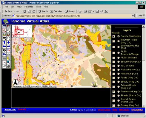
O'Dea, E.K. (2002). Integrating Geographic Information Systems
and Community Mapping into Secondary Science Education: A Web GIS Approach. Masters Thesis, Oregon State
University, Corvallis, Oregon.
Accompanying website: www.geocities.com/gisliz2002/
The purpose of this project was to
find an approach to using GIS in the classroom that is less complex for
teachers to learn and teach. More of
the focus in the classroom could then be on GIS as a tool rather than focusing
on the teaching of the technology. The
approach developed was that of ArcIMS (Arc Internet Map Server) which allows
GIS to be performed over the Internet so teachers and students can also access
GIS away from a computer classroom. The
paper describes the development of a virtual atlas of information on Tahoma,
Washington that can be incorporated into science lessons on water quality, land
use, vegetation, geology, plate tectonics, animal habitats, watershed studies,
mapping, and global warming. See the
homepage for the atlas below. Along
with a description of these examples and an explanation of the website, the
article includes a very helpful list of recommendations to integrate a web GIS
into the secondary classroom.
Tahoma Virtual Atlas Website (OÂDea,
2002)
Patterson, M.W., Reeve, K., and
Page, D. (2003). Integrating Geographic
Information Systems into Secondary Curricula.
Journal of Geography 102:
275-281.
The goal of this study was to
determine whether the integration of GIS into secondary geography classrooms
assists student learning. The paper
begins with a helpful history of research on the effects of incorporating GIS
into the classroom. Then the authors
describe the setup where an AP Geography class in a high school was taught with
GIS and then given the same assessment as college freshman in a beginning
geography class at the same level without GIS training. Though test scores were not overall as high
as researchers anticipated, the high school students outperformed the college
students by 17% supporting previous research that GIS technologies are
beneficial to teaching in the secondary classroom. The authors also address the advantages of the partnership that
was formed between the high school teacher and GIS-trained college professor.
Reed, P.A. and Ritz, J.
(2004). Geospatial Technology. The Technology Teacher 63, no. 6: 17-20.
Reed provides a helpful
introduction with definitions and examples of these uses of geospatial
technology  thematic mapping, global positioning system, remote sensing,
telemetry, and geographic information systems.
The author then provides a web activity for students to experience each
of these uses including a Âdesign brief, a Âchallenge, hints, and how to
evaluate student work.
Related Links
ESRI GIS for K-12 Education: http://www.esri.com/industries/k-12/index.html
North Carolina State University Â
GIS in Education: http://www.ncsu.edu/gisined/what.html
National Center for Geographic
Information and Analysis  Education: http://www.ncgia.ucsb.edu/education.html
The
Kansas Community of K-12 GIS Educators: http://kangis.org/
GIS and Environmental Science for K-12 Teachers: http://www.woodrow.org/teachers/esi/1997/02/GISandES.htm
Education at USGS Rocky Mountain Mapping Center: http://rockyweb.cr.usgs.gov/outreach/index.html
GIS in Schools:
http://egis.eagle.co.nz/schools/index.htm
GIS in Education, K-12 and Beyond: http://www.adkgis.org/resources/educmtg03.html
Spatial News: GIS Education: http://spatialnews.geocomm.com/education/links.html