Introduction
Throughout modern geographical thought and study, agricultural
geography in particular has been primarily reliant on biophysical data
for analysis (i.e. climate, soils). However, more recent inquiries in
planning and land conservation have acknowledged the important role of
both ecological and socio-economic activities in determining
agricultural land use and location. As the American West continues to
experience rapid growth and change, especially in rural areas, the
relationship between the human and non-human world has become
especially noteworthy as high rates of land conversion and development
threaten wildlife corridors, sensitive ecosystems, native species, and
natural fire regimes. For these reasons, it is imperative that spatial
analyses of agricultural land change in the West be examined both from
both physical and human geography criteria. To do this, the use of
geographic-information-systems (GIS) will be invaluable.
Brown, D. G., Johnson, K. M., Loveland, T. R., and D. M. Theobald. 2005.
Rural land-use trends in the conterminous United States, 1950-2000. ECOLOGICAL APPLICATIONS 15(6): 1851-1863.
This study attempts to create a large national-level data set
concerning land-cover data and population changes over a fifty-year
period. Combining Landsat satellite data with US Census information for
each decade, the researchers aimed to summarize changes in population
densities, farmland, and county-level transitions from non-metropolitan
to metropolitan classification. Data sources for population were
acquired from the US Census, although the temporal scale did no match
that of the Census of Agriculture, forcing the researchers to use dates
with the closest correlation. Interestingly, the study classified
agricultural land as land in crops, justified by the fact that cropland
indicators are generally the most consistent and reflect the most
intensive use of agricultural activity. Challenges faced in creating
the data set included finding historical sources of land cover
information as well as dealing with only county-level data, which is
admittedly too large for finer-scale analysis of fragmentation
processes and land use change, not just land cover. While this data sat
was successful in representing national trends in population and land
cover changes, the authors recognize a need for further research in
land use activities and corresponding demographic data.
Brown, K., and M. Pisarski.
GIS Analysis to write a comprehensive county farmland preservation plan. ESRI Virtual Library. Accessed 15 January 2007.
This study responds to the need for a GIS tool to aid in determining
which farmland parcels qualify for agricultural land protection under
New Jersey’s purchase and transfer of development rights program. In
order to create relevant maps, the authors describe the use of ArcGIS
and ArcGIS Spatial Analyst to combine data concerning soils, current
zoning from the State Planning Area criteria, and farm parcel location
relative to other agricultural economic activities. In order to meet
the project’s objectives, the three data sources were converted to a
raster format where each variable was assigned a value related to their
attributes. The combination of all of these layers resulted in the
Prioritized Farmland Layer which was later further analyzed to produce
a final map with information including which farm parcels were already
located within zoned agriculture areas and which parcels still required
protection from encroaching urban sprawl and suburban development. This
article shows how local-level planning bodies can effectively and
efficiently spatially analyze natural amenities like prime farmland, a
large issue affecting rural Western communities.
Carsjens, GJ, and W van der Knapp. 2002.
Strategic land-use allocation: dealing with spatial relationships and
fragmentation of agriculture. LANDSCAPE AND URBAN PLANNING 58 (2-4):
171-179.
In response to the need for topographical
analysis of land-use in Dutch agriculture, this study explores the use
of GIS as a tool for aiding in farmland planning and policy. To
accomplish this goal, two case studies are explored, each relying on
three phases of geographical analysis: (1) the exclusion of land
parcels deemed unsuitable for agricultural activity (either diary or
pig farming), (2) examination of remaining parcels for future farmland
used based on multi-criteria evaluation (MCE), and (3) analysis of
results. In both the dairy and pig farming examples, creating and
employing a GIS allows for the creation of maps indicating locations
where agriculture would be best suited. Overall, this study effectively
meets the needs of agricultural planning, which must take into account
biophysical factors as well as spatial correlation and socio-economic
data.
Greenwood, R. W. 2002.
Using MapServer to Integrate Local Government Spatial Data. Proceedings
of the Open source GIS – GRASS users conference. Trento, Italy: 1-7.
This article provides an intriguing examination of GIS data
organization within a single county, Teton County, WY, which is also
notable for its recent rapid growth rates and planning limitations
(only three percent of land in the county is privately owned). In this
case, GIS data for individual land parcels was originally being held in
five different DBMS, with limited to no interaction between them. The
author was hired to consolidate the databases and make them accessible
to a variety of parties, resulting in the creation of a web-based GIS
that was less expensive in software costs and reduced local staff
training time. After ruling out the use of MapXtreme and ArcIMS,
MapServer, the open software choice, was selected for the project. The
biggest challenge was providing an efficient means of displaying the
variety of attribute data, including parcel owner and address, deeds
and other legal documents such as easements. This article is also a
useful tool in that it identifies the sources of such land use and
ownership data that is integral to planning for agricultural and open
spaces, such as development regulation, building and construction
permits, tax assessments and where to find them at the local level.
LaGro, J. 1998.
Landscape context of rural residential development in southeastern Wisconsin (USA). LANDSCAPE ECOLOGY 13: 65-77
This study focuses on the problem of rural residential development and
sprawl in rural locations in Wisconsin. Applicable now to most Western
states, this issue is examined through the inclusion of a multitude of
different data sources, including aerial photographs, historic and
current land use maps, tax assessment records, and various soil survey
maps and documents. Using the locations of three different types of
sewer systems, whose criteria for placement are based on land
suitability for development, the study creates a GIS to analyze trends
in rural sprawl in previously undeveloped land parcels. The author is
successful in creating adequate representations of sewer placements
over time, therefore demonstrating the more recent rural residential
development in Wisconsin that is enabled by the allowance of
alternative sewage systems.
O’Looney, J. 2000.
Using GIS to promote Community Viability: Land Use Planning. In Beyond
Maps: GIS and Decision Making in Local Government. Redlands: ESRI
Press. pp. 133-153.
This chapter outlines numerous uses of GIS in local government land use
planning and regulation, using specific, municipal-level examples.
Applicable to agricultural land use planning, the author identifies
several such uses of GIS: determining amount of land that needs to be
left undeveloped for open space, calculating amounts of land under
various zoning classifications, and calculating proximities of land
uses that might conflict or be highly compatible. This is important for
agricultural land management as incompatible land uses, such as
residential development, can result in nuisance claims by both parties.
Because farmland preservation often cites the preservation of open
spaces as an added benefit, the article is also useful in its
examination of layers needed in a GIS to determine appropriate
locations for open space planning. These layers include land use and
parcels, zoning classifications, transportation corridors and greenbelt
locations.
Radeloff, V. C., Hagen, A. E., Voss, P. R., Field, D. R., and D. J. Mladenoff. 2000.
Exploring the spatial relationship between census and land-cover data. SOCIETY AND NATURAL RESOURCES 13: 599-609.
This study acknowledges the important relationship between ecological
and socio-economic data inclusion in GIS tools. Using a northwest
Wisconsin case study as an example, the authors combine Landsat high
resolution imagery with census data to uncover relationships between
land cover and housing densities in an area growing due to amenity
migration and recreation resources. Challenges with this type of study
included differences in spatial resolution between census and satellite
sources, requiring additional steps in the creation of the GIS to
combine the layers that included reformatting the census information
(housing density) into raster-compatible data. This was accomplished by
creating a cell size that was appropriate for the Landsat data. The
study concludes with warnings about making assumptions of causation in
this research area, such that it would be irresponsible to claim that
housing density causes variations in land cover. Using the example of
farm locations and pine tree coverage, it is equally likely that the
poor soils that pine trees thrive on are unsuitable for agriculture.
Ricker, T. P.
ArcGIS & Farmland Assessment. ESRI Virtual Library. Accessed 15 January 2007.
This article outlines primary steps and procedures for creating a GIS
for farmland assessment purposes. While the author is negligent of
human-oriented data sources, this study does provide integral
information for researchers or policy-makers who would like to build
their own GIS based on land parcels, land use and soil survey data. One
of the most pressing issues is the use of current and accurate data
sources and maps in order to properly correlate between layers and
avoid errors in calculation. Data sources recommended in the article
include aerial photography, a county- or municipal-level parcel map,
and soil surveys from the NRCS. In recent dates, most of this data is
already available in a digital raster format, which can be converted to
vector format for a research project. The combination of the three data
sets, parcels, soils, and land-use, can then be combined into an
overlay file where all attributes are combined in each polygon and
available in a database. Overall, this article serves as a basic
introduction to using ArcGIS to perform more basic farmland assessment
tasks, but remains ignorant of socio-economic data that could be
obtained from census data, as included in more recent academic studies.
Tulloch, DL, Myers JR, Hasse, JE, Parks, PJ, and RG Lathrop. 2003.
Integrating GIS into farmland preservation policy and decision making. LANDSCAPE AND URBAN PLANNING 63 (1): 33-48.
The authors outline and weight the costs and benefits of creating a GIS
for farmland preservation strategies. Using a New Jersey city as a case
study, an area experiencing strong development pressures and already
having made a geospatial database, the system includes numerous
weighted criteria for its analysis of which farmland holdings are best
incorporated into a farmland preservation program. The criteria include
productive soils, the compatibility of adjacent land uses, the distance
to the nearest protected farm, and public approval and action on
farmland preservation in general, as indicated by right-to-farm laws
and zoning, for example. By organizing this data and applying the
appropriate weights, area officials could avoid manual computation of
these values, saving time and avoiding error. Notable of this approach
was the incorporation of a wide number of data sources, the county
alone providing data on land parcels, tax assessments, zoning, roadways
and transportation, hydrology and open space. State and federal bodies
like the NJ DEP and NRCS supplied other data, like soils and wetlands
coverage.
Ventura, S. J., Niemann, B. J. Jr., Sutphin, T. L., and R. E. Chenoweth. 2002.
GIS-enhanced land-use planning. In Community Participation and
Geographic Information Systems. W. J. Craig, T. M. Harris, and D.
Weiner (eds). New York: Taylor and Francis. pp. 113-124.
This study examines the use of GIS and land information in influencing
local planning efforts. The case study was conducted in Dane County,
WI, which, while one of the most rapidly growing area in the Midwest,
also maintains some of the highest agriculturally productive land,
lending itself to contentious debate over land use issues. In order to
determine whether the provision of geospatial information affects
community land use decision making, the researchers partnered with the
local university, two planning bodies and ESRI to conduct a series of
outreach events, ranging from public forums (including online),
publications, software trials and training, and hands-on planning
scenarios where community members and officials could access and
analyze geographical data about the county that was made accessible
largely by the efforts of the university’s Land Information and
Computer Graphics Facility. While the study was too short-term to make
final conclusions about how these activities would eventually affect
land use decisions in the county, preliminary observations indicate
that citizen awareness and training in GIS has greatly enhanced public
awareness of land use issues, whether a developer, farmer, or urbanite
in Dane County.
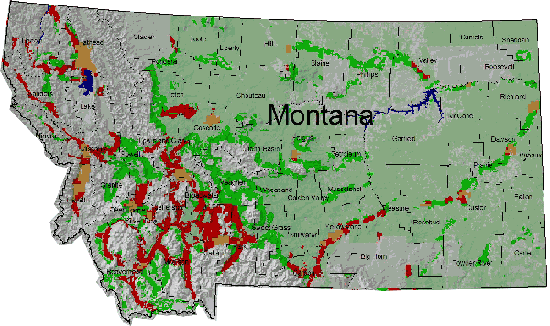
American Farmland Trust
This web page, hosted by American Farmland Trust (AFT), serves to
provide public information and outreach regarding the relationship
between population growth rates in the Rocky Mountain West and
ranchland protection needs. Rural residential development (RRD) is
listed as a root cause of ranchland threats in CO, ID, UT, NM, WY, AZ,
and MT. The AFT states that protection of these lands is important due
to their contribution to local and regional economies as well as open
space and ecosystem services. In order to map which lands are most at
risk, the AFT determined appropriate properties based on (i) high
quality land for both agriculture and wildlife, defined by development
densities, location in reference to public lands, water availability,
and land cover; (ii) threatened lands, defined by projected growth
rates and road corridors; and (iii) the combination of both categories,
such that prime land threatened by RRD is identified. Results in the
form of a GIS show that high rates of threatened lands occur in the
Greater Yellowstone Ecosystem and are often located in high elevation
valleys as well as lower grasslands in vicinity of regional mountain
ranges. Overall, this site provides a basic overview and justifications
for protecting private ranchland in the West, although because the
investigators are from a land trust, it could be possible that
information is limited to presenting only this view (i.e. the argument
against protecting rangeland in water-limited areas is not elaborated
on).
An example of the final product for the state of Montana is
shown below. Areas marked as red indicate "strategic ranchlands at
risk."