
[ home port | lectures | labs | discussion | announcements | surf | email prof. ]
 Lab 2
Lab 2
Materials: Heezen & Tharp seafloor topography map provided in lab, calculator
Introduction
What do you imagine is on the bottom of the deep ocean floor? Do you picture it as a big, smooth bathtub with green slime on the bottom and perhaps a few giant fish swimming around in the dark, freezing cold? The ocean floor has this and more! In fact, all of the major landforms that we find on the continents (mountains, valleys, plains, gigantic canyons, etc.) are found on the ocean floor as well. It is anything but smooth!
Mountains Under the Sea
There are 2 common types of mountains on the seafloor, both volcanic: mid-ocean ridges and seamounts.
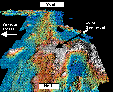
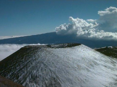
Mid-ocean ridges, also called seafloor-spreading centers, are long, linear volcanic ridges formed where the seafloor cracks into 2 plates of oceanic crust that spread away from each other. The cracks between the diverging plates of lithosphere are filled with magma that rises from the mantle beneath mid-ocean ridges, and solidifies into new oceanic crust along the crest of the mid-ocean ridge. Repeated cycles of cracking, spreading, melt injection, and solidification of new crust along mid-ocean ridges over long periods of time (tens to hundreds of millions of years) produces large plates of oceanic lithosphere that floor entire ocean basins. For this reason, we say that the seafloor is "born" or "created" at the mid-ocean ridges. The figure below is a shaded relief map of the Juan de Fuca Ridge, part of the global mid-ocean ridge system that lies 300 miles off the coast of Oregon and Washington. The view is from the north looking south (a test of your map orientation skills!). This portion of the Juan de Fuca Ridge has a large volcano atop it called Axial Seamount. Recall that Axial Seamount is the feature that you drew a profile of in Lab 1.
Mid-ocean ridges are very active features. Some are spreading apart at the
same rate that your fingernails grow. In geologic time this is very fast! It is
possible to calculate the spreading rate of one side of a mid-ocean ridge by
dividing distance by time (Distance/Time = Rate). This is called a
half-spreading rate. Multiply it by 2 to get the full spreading
rate for both sides of the ridge. In some cases, distance would be how far
a portion of the seafloor has moved away from the crest of the mid-ocean ridge.
The rate would be the age of that portion of the seafloor in years. Or distance
may be the distance from the crest of a mid-ocean ridge to the edge of a
continent. Rate would then be the difference in age between the ridge crest and
the continent. Here is an example to practice with:
1 km = 100,000 cm or 1 x 105 cm
2400 km = 2.4 x 10³ km = 2.4 x 108 cm
120 my = 1.2 x 10⁸ yr
Rate = Distance or 2.4 x 108 cm / Age Difference or 1.2 x 10⁸ yr
Rate = 2 cm /yr
FULL rate = 2 cm/yr * 2 = 4 cm/yr
The Mid-Atlantic Ridge on the whole is an example of a mid-ocean ridge with a SLOW spreading rate (1 to 5 cm/yr, full rate). The Juan de Fuca Ridge and Southwest Indian Ridge are classed as INTERMEDIATE-rate ridges (6 to 9 cm/yr, full rate), and the East Pacific Rise is a FAST-spreading ridge (10 cm/yr or greater, full rate).
Seamounts are submerged volcanoes on the seafloor. They may be active or extinct, and may occur as isolated peaks, as groups, or as linear chains. These regions of activity may be associated with mid-ocean ridges, as is the case with Axial Seamount pictured above, with hot spots in the mantle (as is the case with Loihi Seamount, which will one day become the newest island of Hawaii) or with subduction zones.
Other Features Under the Sea
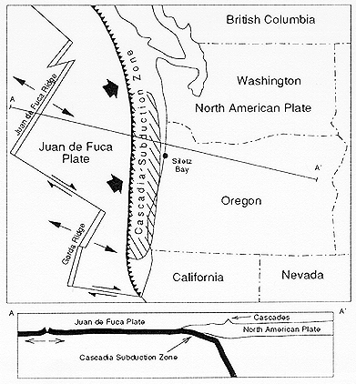
Subduction zones are places where an oceanic plate is bending down into the mantle and sinking (subducting) beneath another oceanic or continental plate. A very deep trench is formed parallel to the zone of collision. Here in the Pacific Northwest, not only do we have the Juan de Fuca and Gorda seafloor spreading centers offshore but there is the Cascadia Subduction Zone as well. Study the figure below which was provided courtesy of the Oregon Department of Geological and Mineral Industries.
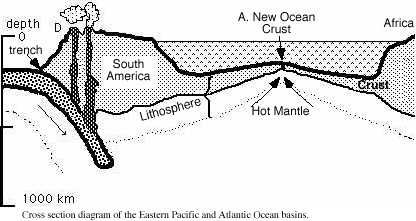
Here is a transect across another portion of the eastern Pacific Ocean (we are on the WEST coast of North America but the Pacific Ocean at our doorstep is the EAST Pacific), as well as the Atlantic.
In referring to mid-ocean ridges and subduction zones we've really been talking about major plate tectonic boundaries. Mid-ocean ridges are places where new plates are formed and subduction zones are places where plates are destroyed. A transform fault is a third type of plate boundary. This is where plates slide past each other.
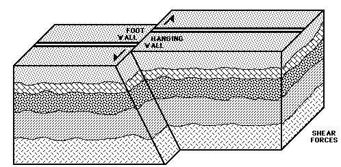
The San Andreas fault in California is such a place. Or on a more detailed scale, portions of the mid-ocean ridge are often separated by smaller transform faults that form where the diverging plates are slipping laterally past each another. The rugged topography resulting from the deformation of the seafloor along transform faults is carried away with the spreading plates and forms inactive extensions of the transform faults, called fracture zones.
The seafloor also has huge, flat, deep areas where sediments have buried the rough volcanic terrain that was created at mid-ocean ridges. These places are called abyssal plains.
In this lab, you will use a large (and very beautiful) seafloor topography map that will show you all of the above features. Study the map carefully and answer the questions below.
Part 1 - The Atlantic Ocean
(1) The major topographic feature of the Atlantic Ocean floor is called the
____________________________
(2) What kind of mountain range is it? (mid-ocean ridge or seamount chain?)
____________________________
(3) What is the name of the large island where this features rises above sea level?
____________________________
(4) Locate and name the three trenches along the outer margin of the Atlantic Ocean.
____________________________________________________________
(5) Are these trenches an unusual feature of the Atlantic Ocean or are they fairly widespread? How does this compare with the Pacific? _____________________________________________
Part 2 - The Pacific Ocean
(1) The western Pacific basin is characterized by which kind of mountains: mid-ocean ridges are seamounts? ___________________________
(2) The Hawaiian-Emperor Chain is a linear set of islands and seamounts. List 2 other seamount chains in the Pacific and compare their orientation to the Hawaiian-Emperor chain. Did they form at the same time as the Hawaiian or Emperor part of the chain? (Note that on this map, the Big Island of Hawaii lies at the end of the chain over the Hawaiian hot spot. This map was made before the discovery of Loihi Seamount which is now the newest expression of the Hawaiian hot spot on the seafloor).
(a) ___________________________ Same time as: Hawaiian Emperor
(b) ___________________________ Same time as: Hawaiian Emperor
(3) Where would you expect to find the youngest oceanic crust in the Pacific Ocean? ______________________________________________________
(4) Where would you expect to find the oldest oceanic crust? (Name the trench or plateau that this old crust would be adjacent to) ______________________________________________________
(5) Find 2 areas (one along a continental margin and the other away from a continent) where trenches occur. Name them:
(a) ______________________________________________________
(b) ______________________________________________________
(6) The Pacific Ocean is rimmed by high volcanic and seismic activity. There
are active volcanoes in the Cascades of our Pacific Northwest, in the Aleutian
Islands, and in the Andes, but almost none within California. Explain why
California is so "fortunate." (Actually they have their fair share of problems
down there in California  ,
but as a hint, what type of plate boundary do they have down there between the
Pacific and North American plates?)
,
but as a hint, what type of plate boundary do they have down there between the
Pacific and North American plates?)
(7) Where might you find active volcanoes in the Pacific basin not related to trenches and the subduction of oceanic plates? Name 2 different places:
(a) ______________________________________________________
(b) ______________________________________________________
(8) How tall is Mauna Kea volcano on the Big Island of Hawaii, from its base on the seafloor to its summit? (The height of Mauna Kea above sea level is shown on the world map just below the I in Hawaiian Islands, and the depth of the volcano below sea level is shown below that at approximately 16° N latitude, 155° W longitude).
Height = _________________________________
Mauna Kea is often cited as the tallest mountain on Earth. For comparison, Mt. Everest stands about 8.84 km (8840 m) above the plains of India.
Last update: March 23, 2003
http://dusk.geo.orst.edu/oceans/lab2.html
Dawn Wright & Bob Duncan © 1999