This paper appears in

The Journal of Geophysical Research - Solid Earth, 107(B5),
10.1029/2001JB000544, 2002.
© Copyright reserved by Dawn Wright
and the American Geophysical Union
May be freely distributed electronically in whole or in part, but please keep
this notice attached
and do not alter the text. This article is slightly
longer than the final published version.
Last update: May 17, 2002
Crustal Fissuring on
the Crest of the Southern East Pacific Rise, 17°15’-40’S
PDF file (712 K) |
Cruise web page |
References
Dawn J.
Wright1, Rachel M. Haymon2, Scott M.
White2,3, and Ken C. Macdonald2
1Department
of Geosciences, Oregon State University, Corvallis,
Oregon.
2
Department of Geological Sciences,
University of California, Santa Barbara, California.
3
Now at:Department of Geological Sciences,
University of South Carolina, Columbia, South Carolina.
Abstract.
Fissure
densities and widths have been mapped along the axial zone
of the superfast-spreading southern East Pacific Rise (EPR)
at 17º15’-40’S with the near-bottom DSL-120
and Argo II imaging systems. We observe that the
youngest lava flows (on a relative age scale) are sparsely
fissured, and that there is a cumulative increase in
fissure abundance with time that produces a strong positive
correlation between fissure density and relative age of
lava flows. Average fissure widths were used to estimate
fissure depths. In the 17º15’-40’S area,
calculated fissure depths are estimated to extend below the
seismic Layer 2A/2B boundary, and fissures are
widest/deepest where lava flows are youngest. We interpret
these wide fissures in relatively young flows to be
eruptive fissures. Relatively young lava flows combined
with high average fissure widths south of 17º
25’S suggest that there may have been recent dike
propagation along the ridge crest in this area. In
comparison to the northern EPR at 9º-10ºN, the
density of fissuring on the southern EPR is significantly
higher, due in part to the higher occurrence of relatively
older, more areally-restricted pillow lava flows.
Keywords: fissures, fractures, mid-ocean ridges,
southern East Pacific Rise, tectonic cycle
GAP index terms: 3035 Midocean ridge processes;
8010 Fractures and faults; and 3045 Seafloor morphology and bottom photography
Introduction
The superfast-
spreading southern East Pacific Rise (EPR) exhibits a
number of features that make it different from slower-
spreading mid-ocean ridges (MORs), including its relatively
long segments, separated by infrequent and small offsets,
an inflated cross-section, pronounced asymmetry in
spreading rate and subsidence, and an abundance of off-axis
lava flows and seamounts [Scheirer et al., 1996a;
Scheirer et al., 1998]. Still poorly understood are
the along-axis extent and frequency of diking events and
eruptions, as well as the width of the subsurface dike
intrusion zone (although the recent Autonomous Benthic
Explorer data of Cormier et al. [1999] and Shah
et al. [1999] are shedding light on this). On other
parts of the MOR and in Iceland much attention has been
given to the study of dikes (i.e., magma-filled cracks),
mainly in connection to faulting and magmatism.
However, in order to fully understand the nature of
mechanical failure in an extensional environment, one must
also consider the location, distribution, and geometry of
fissures, which provide essential pathways into the upper
oceanic crust through which magma and hydrothermal fluids
may migrate. In the past this has been difficult on the MOR
because of the lack of good quality data at the scale of
meters to tens of meters. Crane [1987] was the first
to tabulate fissure abundance and length along the axial
zone of the EPR (using the side-looking sonars of the deep-
towed Sea MARC I with selectable swath widths of 1.5, 3,
and 6 km at 10
°35’ to
13°10’N). No further studies focusing
primarily on fissures were performed on any part of the MOR
until the 1989 Argo I survey of the northern East
Pacific Rise (EPR) at 9°12’ -
54’N [Wright et al., 1995a and b] and the 1994
Argo II survey of the Trans-Atlantic Geotraverse
(TAG) active hydrothermal mound at 26°N on the Mid-Atlantic Ridge (MAR)
[Bohnenstiel and Kleinrock, 2000]. These surveys
provided the first, and at present the only, data sets that
were of sufficient density, continuity, and geographical
precision to meaningfully map and analyze fissure
distributions at a fine-scale, along with distributions of
hydrothermal vents, lava flows, and biological communities
[e.g., Haymon et al., 1991].
In this study we present an analysis of fissure
characteristics along the superfast-spreading southern EPR,
and compare the results to those obtained previously along
the fast-spreading northern EPR. We used the high-
resolution, near-bottom imaging capabilities of the Argo
II optical/acoustical system and the DSL-120 deep-towed
sonar system to establish the abundance, widths, and
spatial distribution of fissures, as well as the estimated
depth of fissuring, along the axial zone of the southern
EPR at 17
°15’-
40’S (the "Spike survey") and 18°23’-30’S (the "Hump survey").
Statistical analyses characterize fissure density, width,
length, and depth on both a 3rd- and 4th-order segment
scale. These finer scales of segmentation are typically
characterized at the 3rd-order scale by very small
overlapping spreading centers (OSCs; offset less than ~1
km), local topographic lows (saddle points), or small
deviations from axial linearity (Devals); and at the 4th-
order scale by even smaller Devals (offset less than 200
m), intravolcano gaps and offsets of axial summit troughs
or calderas (White et al. [2000] as modified from
Macdonald et al. [1991]). Analysis of the spatial dimensions of
fissures at these segment scales is critical to
understanding the processes controlling their geometry.
Fissures may either be of magmatic origin (forming above
subsurface dikes that sometimes reach the seafloor and
erupt) or tectonic origin (forming in response to lateral
tensional stress), reflective of tumescence/detumescence
(inflation/deflation of ridge axis over a magma chamber) or
thermal contraction (shrinkage of cooling rock). With the
passage of time, fissure abundance may increase [Wright
et al., 1995a and b], and existing fissures may widen
by mass wasting of their margins, or by extension.
Geological
Setting
The southern EPR
(Figure 1) has been the focus of numerous surveys and
geophysical experiments, particularly between the Garrett
Fracture Zone and the propagating ridge at 20.7
°S [e.g., Lonsdale, 1989;
Macdonald et al., 1988; Scheirer et al.,
1996a and b; Magde et al., 1995; Carbotte et
al., 1997; Scheirer et al., 1998]. This section
of ridge is ~800 km long, representing a remarkably
uninterrupted, long-wavelength undulation in axial depth.
Major morphotectonic/magmatic segments separated by six
OSCs and one deval, have been previously identified. All
are in varying stages of tectonic, magmatic, and
hydrothermal development [e.g., Lonsdale, 1989;
Sinton et al., 1991; Auzende et al., 1996;
Cormier et al., 1996; Scheirer et al.,
1996a]. The ridge axis is offset on a finer scale by a
series of small, en echelon, left-stepping discontinuities
ranging in offset from 1 to 7 km [Cormier et al.,
1996]. The ridge segments in between these offsets all
strike consistently within a few degrees of 013°, which is normal to the direction of
spreading predicted by the NUVEL-1A model of current plate
motions [DeMets et al., 1994].
|
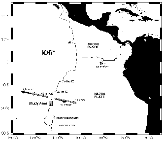
Figure 1.
Regional
location map of the study area (marked by gray box) on the
southern EPR. Plate boundaries are from Cormier et
al. [1996]. Arrows near study area are Pacific-Nazca
plate motion vectors (after Cormier et al., [1996]).
Solid arrows represent absolute motion and gray arrows
indicate relative motion. Overall, the Pacific Plate is
moving significantly faster over the hotspot reference
frame than the Nazca Plate (101 mm/ yr versus 45 mm/yr)
[Gripp and Gordon [1990]). Because both the absolute
and relative plate motion directions are nearly ridge-
perpendicular, the EPR axis is migrating by about 30 mm/yr
to the WNW over the hot spot frame of reference
[Scheirer et al., 1996a]. At the ridge axis,
spreading is significantly faster to the east than to the
west [e.g., Naar and Hey, 1989; Perram et
al., 1993; Hey et al., 1995]. Since 1 Ma, the
average Pacific rate of spreading has been ~69 mm/yr while
the average Nazca rate has been ~78 mm/yr; full spreading
rate is ~147 mm/yr [Cormier et al., 1996].
Click on the image for an expanded
view
|
North of an OSC at 19
°S, the ridge
axis is particularly robust magmatically, as evidenced by
its shallow, broad, inflated cross-section [e.g.,
Scheirer and Macdonald, 1993; Cormier and
Macdonald, 1994] and abundant hydrothermal activity
[e.g., Backer et al., 1985; Renard et al.,
1985; Marchig et al., 1986; Auzende et al.,
1996; Baker and Urabe, 1996]. Seismic data show a
strong reflection from the top of the axial magma chamber
(AMC), which is generally ~1 km below the seafloor, as
opposed to the 1.2-1.6 km depth typical of the northern EPR
[Detrick et al., 1993; Mutter et al., 1995].
However, the morphology of the ridge crest changes
drastically between the two 2nd-order segments north and
south of the OSC at 17°56’S
[Ballard and Francheteau, 1982; Renard et
al., 1985; Lonsdale, 1989; Auzende et
al., 1996]. Between 16°30’S and
17°56’S the ridge has a broad, domed
cross section that is widest and most shallow at
~17°25’S [Renard et al., 1985;
Auzende et al., 1996]. The seismic data of
Detrick et al. [1993] at this location show that the
AMC changes dramatically along-strike from a flat-topped
body at relatively constant depth to a peaked cupola
("spike") that intrudes to within 800 m of the seafloor,
thus representing the most extreme along-strike thermal
gradient to be documented along any portion of the global
MOR. For example, if it is assumed that the temperature of
melt at the top of the magma chamber is ~1200°C
[Lin and Parmentier, 1989], then the vertical
temperature gradient in this region changes from
~900°C/km to ~1200°C/km over a distance of less
than 5 km, and from ~900°C/km to ~1700°C/km over
~ 30 km. Mutter et al. [1995] have interpreted this
as seismic evidence for an axial eruption in progress.
Indeed, subsequent to these seismic surveys, a 1993
Nautile dive series from 16°30’S to 17°56’S found extremely young lava flows
containing numerous collapse pits, as well as a general
absence of fissures in these relatively young flows
[Auzende et al., 1996]. Similar observations were
made in 1994 and 1997 with the Shinkai 6500
[Fujioka et al., 1995; Urabe et al., 1995;
Embley., 1998] and in 1998 with Alvin
[Sinton et al., 1999]. A 1996 survey of the ridge
crest with the DSL-120 deep-towed sonar (see below)
revealed the presence of two narrow (<50 m wide)
collapse troughs at 17°26'-29’
(Aldo Lake Trough) and 17°42'-45’S
(Pisco Trough) [Haymon et al., 1997; Haymon et
al., in prep.]. Macdonald and Fox [1988],
Haymon [1996] and Lagabrielle and Cormier
[1999] have suggested that some, if not most, axial summit
troughs (ASTs) along both the northern and southern EPR
represent elongate collapse calderas formed above magma
chambers, rather than rifted features resulting from stages
of dominantly amagmatic extension. The AST at
17°26’-29’S represents drainback during the
waning phases of an eruption in the AST model of Fornari
et al. [1998] (stage 1b of 4).
In contrast to the northern section of ridge at
16°30’-17°56’S, the 75-km section to
the south is notched by a prominent trough bisecting the
axial high, varying in width from 500-2000 m and reaching
up to 100 m in depth [Ballard and Francheteau, 1982;
Lonsdale, 1989; Lagabrielle and Cormier,
1999]. The ridge from 17°56' to a 3 km-wide OSC at
18°22'S is primarily a half graben. The next 25 km
from 18°22’S to 18°35’S is known as the
"Hump" because of its markedly convex topographic profile
along-axis. Observations made here by various
Nautile dive series [Bäcker et al.,
1985; Renard et al., 1985; Auzende et al.,
1996], and later confirmed by the Argo II survey of
Haymon et al. [1997], indicate that the trough is
floored throughout with lava flows that are cut by numerous
fissures and buried by talus near the walls.
Data Acquisition
and Analysis
In late 1996, the
Argo II and DSL-120 seafloor imaging systems
[Bowen et al., 1993; Scheirer et al., 2000]
were used to conduct a near-bottom survey of the narrow
(<500-m-wide) axial zone of the southern EPR from
17
°15’S to 18°30’S (135 km; Figure 1). This study
focuses on the Argo II survey at 17°15’-40’S [Haymon et al.,
1997]. Initially, the DSL-120 was used above the seafloor
to collect 120 kHz sidelooking acoustic reflectance and
phase bathymetry data within a continuous, 1 km zone of
ridge crest (towing height of ~75 m yielding an imagery
swath of ~1000 m) [White et al., 2000]. Argo
II was then towed at ~6-10 m above the seafloor to
conduct dense visual, acoustic (200 kHz), magnetic, and
water column surveys within the DSL-120 sonar survey area,
first at Spike and finally at Hump. Fifteen axis-parallel
lines through the axial zone with line spacings of 10-30 m
(see Haymon et al. [in prep.] for trackline maps)
provided 80-100% visual coverage where the axial zone is
less than 100 m wide, down to a minimum coverage of ~45%
where the axial zone widens at 17° 25'S. The maximum
width imaged within the Spike survey area was ~700 m.
Calculations were made of the area of axial zone
visually imaged during the Argo II survey, based on
the field of view of its forward-looking camera (~16 m at 9
m above the seafloor), which provides a greater swath width
than the downlooking cameras (Figure X). The calculations are based on
the geographic information system (GIS) buffering and clipping
procedures established by Wright et al. [1995a], but
further take into account the varying altitude of Argo
II. Haymon et al. [in prep.] more fully
discusses the characteristics of all cameras and
instruments used on Argo II. These calculations were
necessary for an accurate determination of fissure density,
which, after Wright et al. [1995], is defined as the
number of fissures per square km of seafloor visually
imaged. For the current study, fissures were counted and
measured from Argo II forward-looking video,
electronic still camera (ESC) photography (Figure 2), and
cross-track Imagenex, 675kHz, mechanical sonar traces.
Processing of the video and ESC data, analysis, and
histogram construction follow the methodology of Wright
et al. [1995a]. Features within, but much larger than,
the field of view of the Argo II cameras were
digitized in their entirety from DSL-120 sidescan records
(see White et al. [2000] for representative images), and
the digitized coordinates inspected to ensure that counts
of these features were not duplicated in counts from the
visual observables and Imagenex records.
Histograms and graphs illustrating the density, width, and
depth of fissures include data from video, ESC, Imagenex
and side-scan sonar.
|
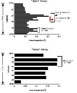
Figure X (not in published version).
Variation in the area of the axial zone
visually imaged along the southern EPR with the forward-
looking video camera of Argo II (which yields the
greatest swath width of all visual observables on the
vehicle). Top histogram represents the "Spike" survey at
17° 15'-40'S, bottom histogram is from visual
surveying of the "Hump" segment at 18° 23'-30'S.
Brackets denote areas that were surveyed with greater
trackline density and have correspondingly greater
coverage.
Click on the image for an expanded
view
|
|
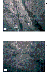
Figure 2.
(a) Argo II electronic still
camera image of two 1-m wide fissures in relatively young
(Age 1) autobrecciated sheet flow along the axial zone of
the Aldo Lake Segment, 17°28'S. Depth ~2600 m,
altitude ~6.5 m. Scale bar at lower left is 1 m. (b)
Argo II electronic still camera image of a contact
between young (Age 1) sheet flow underlying an Age 1 lobate
flow in the axial zone of the Tubeworm Segment,
17°30.5'S. Depth ~2600m, altitude ~6.0 m. Scale bar at
lower left is 1 m.
Click on the image for an expanded
view
|
The 1996 Argo II survey at Hump covered only a
limited portion of that 2nd-order segment (i.e., 9 of the
25 km), which limits its usefulness for correlating fissure
properties with fine-scale morphotectonic segmentation.
There is also evidence that the Hump region has a more
complex history than the Spike region, including periods of
amagmatic extension, and possible massive collapse
[Lagabrielle and Cormier,1999]. The accumulation of
fissure populations from these diverse processes makes the
fissure patterns complicated. As a visual survey of the
entire 2nd-order segment is needed before detailed
interpretations should be attempted, only data and
interpretations for the Spike area are presented here.
Observations and
Calculations
Distribution, Abundance and Widths of Fissures
A total of 1630 fissures (1383 detected by
Argo II video, ESC and Imagenex plus 247 additional
fissures detected by DSL-120 sonar) were observed in the
Spike survey area. Taking into account the heights of the
Argo II vehicle off the bottom, the mean width of
fissures detected by video, ESC and Imagenex is 1.4
m (minimum width = 0.1 m, maximum width = 15 m). A
systematic increase in fissure widths away from the ridge
axis was not observed. Due to the spatial limitations
inherent in video and ESC, lengths were not determined for
the population of fissures observed in the video and ESC
(nor by the Imagenex traces). The mean width of the larger
fissures detected by DSL-120 sonar is 8 m and the mean
length is 111 m. All but four of the fissures observed were
oriented parallel to the ridge axis.
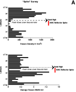
Figure 3 shows a pattern of more abundant, narrower
fissures per unit area north of the axial high and the AMC
reflector spike, trending to fewer and wider fissures south
of it. The fewest number of fissures are found at
17°27’-28’S. This region is centered on the
AMC reflector spike where the freshest, youngest-looking
lava flows are found (Age 0.5 on a scale of 0 = youngest
‡ 2 = oldest; Haymon et al. [1991
and in prep.]).These young, uncracked flows are probably
covering pre-existing fissures [Haymon et al.,
1997;Sinton et al., 1999; Haymon et al., in
prep.] (Figure 4). A region of very wide fissures is found
at 17°27’-32’S, above and just south of the
AMC reflector spike.
|
Figure 3.
Variation along the ridge axis in
fissure density and width for the southern EPR crest at
17°15'-40'S. Top histogram shows density of fissures
per square km of seafloor visually imaged. Bottom histogram
shows average width of fissures (m) in bins of 1' latitude.
Vertical, solid bars to the right of the histograms
indicate latitudinal extent of AMC reflector spike
[Mutter et al., 1995]. Dashed lines point to the
locations of topographic highs along the axis (measured
from walls).
Click on the image for an expanded
view
|
Click on the image for an expanded view
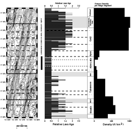
Figure 4.
Distribution of tectonic and volcanic
features along the southern EPR crest at 17°15'-40'S,
modified from Haymon et al. [in prep.]. Bathymetric
contour interval is 20 m, from the Sea Beam 2000 data of
Scheirer et al. [1996b]. Shading indicates areas
shallower than 2700 m. Solid horizontal lines over
bathymetry indicate central latitudes of distinct 3rd-order
discontinuities (after White et al. [2000]), dashed
lines indicate distinct 4th-order discontinuities, and
dotted lines indicate potential 4th-order discontinuities
(both after White et al. [2001]). Vertical, solid
bar to the right of bathymetry indicates latitudinal extent
of AMC reflector spike [Mutter et al., 1995]. Moving
to the right, the next column shows the along-axis
variation in inferred relative lava age, after Haymon et
al. [in prep.]. Each small histogram bar represents the
minimum relative lava age within a 100 m latitudinal bin.
Third-order discontinuities are shaded zones (including
discontinuity boundary zones, DBZs), distinct 4th-order
discontinuities are dashed lines, and potential 4th-order
discontinuities are dotted lines. The last two columns show
the locations of "deval"-bounded ridge segments, as
determined by White et al. [2001], and a horizontal
histogram of the fissure density per ridge segment.
Density and widths of fissuring correlate well with
relative age distribution of axial lava flows throughout
most of the Spike survey area (Figures 4 and 5). North of
17°23’S there is a significant increase in both
inferred relative lava ages and fissure densities, along
with a significant decrease in mean fissure widths (Figures
3 and 4). Similar to previous findings on the northern EPR
[Wright et al., 1995a], the most densely fissured
region lies in the oldest, Age 2 terrain at
17°18’-21’S within a 3rd-order discontinuity
boundary zone [White et al., 2000], while the least
fissured areas at 17°25’-29’S are presumably
very young (Age 0 to 0.5; Figures 3-5). A small region of
Age 2 axial lavas south of 17°38’S, although
populated with numerous fissures, is not as densely
fissured as the Age 2 lavas north of the AMC reflector
spike (Figure 4).
Figure 5 shows a strong correlation between fissure
density and relative lava age within the Spike survey area,
and also shows a measured fissure density that is several
times higher than that found along the northern EPR at 9-
10°N. Although video, ESC, and Imagenex observations
from Argo II are included in the data points for
Spike (Figure 5), while only video observations from
Argo I are included for the 9-10°N data (Figure
5), the fissures observed by ESC and Imagenex in the Spike
area augment the total number of fissures by <15%, and
cannot explain the observed five-fold increase in the
density of fissures when compared to the density of
fissures along the northern EPR. We speculate that the
observed difference in fissure density between the northern
and southern EPR survey areas is due to a comparatively
greater proportion of young sheet flows that have poured
out of the more extensive axial summit collapse troughs
present along the EPR at 9°-10°N (see discussion
section below).
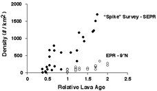
|
Figure 5.
Fissure density versus relative lava
age for 17°15'-40'S (solid symbols), compared to
9°12'-54'N (open symbols). EPR 9°N data from
Wright et al. [1995a]. Relative lava ages were
averaged within the same latitudinal bins as fissure
density. Note how much higher fissure density is along the
southern EPR.
Click on the image for an expanded
view
|
Estimates of Fissure Depth
The depth of a fissure (also referred to here as
"crack depth") is a valuable piece of information because
it has implications for the mechanical conditions under
which the fissure formed, and hence about the history of
the rock in which it occurred [Lachenbruch, 1961].
The deeper the penetration of fissures, the more important
their role in crustal tectonics. For example, deep fissures
serve as conduits for magma emplacement and increase the
permeability of the upper crust for the mobility of
hydrothermal fluids. This in turn has a profound effect on
the mechanical behavior of the crust and on its effective
strength at depth.
Wright [1998 and references therein],
Fialko [2001], and Garel et al. [in press]
review the mechanics of fissure formation in volcanic rift
zones, and describe in detail the background theory,
relevant mechanical factors (i.e., elastic moduli, tensile
stress, and tensile strength of the host rock) and simple
fracture mechanics models applicable to fissure formation
and development at fast-spreading mid-ocean ridges. An
initial caveat is that these models are primarily two-
dimensional, and assume that oceanic crust is uniform,
isotropic, and elastic. Seismic velocity, electrical
resistivity or deep borehole investigations (such as the
recent borehole televiewer studies of Krammer et al.
[1995] and Ito [1995]) may eventually be adequate to
determine the actual depth distribution of cracks within
the study area. However, until in-situ
determinations or a rigorous three-dimensional analytical
solution for anisotropic, heterogeneous ocean crust become
available, one must rely on a two-dimensional solution,
using reasonable values for the linear elasticity and
density of the rock. These two-dimensional models do,
however, rest on a substantial body of experimental
information obtained with terrestrial rocks, metals,
plastics, glass, and concrete, and have met with success in
subaerial studies and engineering applications [Wright
et al., 1995b].
Wright et al. [1995b] employed a width-to-depth
relation for fissures observed along the axial zone of the
EPR at 9-10°N with Argo I. Because the
dimensions of fissures in the Spike survey area are very
similar to those mapped at 9-10°N in terms of width,
length, and mechanics of formation, estimates of crack
depth follow the same assumptions and crack depth model
used by Wright et al. [1995b]. The assumptions are
that: (1) oceanic basement is a uniform, isotropic, elastic
medium; (2) fissures are of finite dimensions, where the
width of the fissure may be controlled either by its depth
or its length; and (3) cracking is of a "top down" mode
where a fissure initiates at the surface (i.e., is not
initially filled with magma) and the depth of penetration
is related to the width of opening. The crack depth model
is a variation on the plane-stress model of Tada et
al. [1973] and Gudmundsson and
Bäckström [1991], as implemented by Wright
et al. [1995b]:
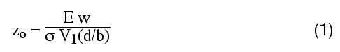
where is zo estimated crack depth, E is Young’s modulus, w is fissure width, and s is the
tensile stress at the time of crack formation.
V1(d/b)
is the stress function of Tada et al. [1973]:
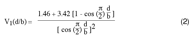
In the stress function above, d
is 300 m (in accordance with a calculated estimate of
zmax, after the methodology of Wright et
al. [1995b]), and b is the brittle thickness of the
crust, which translates to ~1200 m for the southern EPR
[Hussenoeder et al., 1996]. Adopted or calculated
values for these parameters are shown in Table 1. Wright
et al. [1995b] explains the theoretical background on
these parameters and presents explanatory formulas related
to estimates of fissure depth. Again, the models, and the
depth estimates resulting from it, are limited by the
assumption of crustal uniformity, as we know that there are
indeed substantial changes in the physical properties of
the crust with depth all the way down to the AMC. However,
many of these changes are still undetermined for the study
area. An example is the calculation of the Young's modulus
(E) parameter for equation (1), which should be 0.5 of a
dynamic modulus, as determined from seismic results. The
relation, given by Jaeger and Cook [1979] is:
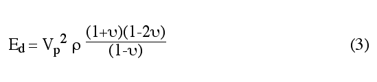
where E
d is the dynamic Young's modulus,
Vp
is P-wave velocity,
n is a static Poisson's ratio, and
r is rock
density (Table 1). Shaw [1994] points out that the
dynamic Poisson's ratio remains largely unknown due to the
difficulty in obtaining direct shear-wave velocity
measurements in young ocean crust, especially in the
uppermost portion. In order to approximate the in-situ
value, one must therefore rely on a static Poisson's
ratio determined from laboratory measurements of basalt.
For the southern EPR, Collier and Singh [1998]
determined a Poisson's ratio of 0.48, but this applies only
to the upper 50 m of crust within Layer 2A; and the value
decays to 0.35 approaching a sub-bottom depth of 200
m. On the EPR at 9°-
10° N, Christeson et al. [1994; 1997] used on-
bottom seismic refraction data to determine a minimum
Poisson's ratio of 0.43 at the seafloor. Similarly, a P-
wave velocity of 4650 m/s may be adopted as an average for
the uppermost 1 km of crust along the southern EPR
([Hussenoeder et al., 1996]; Table 1), but the P-
wave velocity in the upper 50 m that is appropriate for
surface fissuring, and for surface Poisson's ratios of 0.48
or 0.43, is only 2 to 2.5 km/s. Therefore, because our
chosen model is directly proportional to Young's modulus,
there remains great uncertainty in the actual depth and
extent of fissuring.
Table 1.
Elastic moduli and related
parameters used for estimates of fissure depth. See
Wright [1998 and references therein] and Wright
et al. [1995b] for background equations involving these
parameters and a full explanation of how they affect
estimates of fissure depth at fast-spreading mid-ocean
ridges.
|
Parameter |
Definition |
Value |
Units |
Reference(s) |
|
b |
Thickness of crust
(for Tada's stress
function only) |
1200 ±
100 |
m |
Lin
& Parmentier
[1989];
Hussenoeder et al.
[1996] |
|
E |
Static Young’s
Modulus |
980 ± 1000
( u=.48, Vp=2.5)
3400
± 1000 ( u=.48,
Vp=4.65)
5400
± 1000 ( u=.35,
Vp=2.5)
18,500 ± 1000
( u=.35,
Vp=4.65) |
MPa |
This
study |
|
g |
Acceleration of
gravity |
9.8 |
m/s 2
|
|
|
T0 |
Rock tensile
strength |
3+3 / -
2 |
MPa |
Haimson
& Rummel
[1982];
Gudmundsson
[1992] |
|
V1(d/b) |
Tada’s stress
function |
2.56 |
dimensionless |
This
study |
|
Vp
(near surface) |
Avg. P-wave velocity
of uppermost 50 m |
2500 ±
400 |
m/s |
Hussenoeder et al.
[1996] |
|
Vp
(at
depth) |
Avg. P-wave velocity
of uppermost 1 km |
4650 ±
400 |
m/s |
Hussenoeder et al.
[1996] |
|
w |
Crack width |
0.1-
30.0 |
m |
This
study |
|
zmax,
d |
Maximum depth of
absolute tension |
300 ±
100 |
mbsf
(m
below seafloor) |
This
study |
|
zo |
Crack
depth |
to be
estimated |
mbsf |
This
study |
|
u |
Poisson’s ratio
|
0.48
0.35
0.43
(EPR
9° N) |
MPa |
Collier
& Singh
[1998]
Christeson et al.
[1994]; Wright et al.
[1995b] |
|
r |
Avg. rock density of
uppermost 1 km |
2750 ±
100 |
kg/m3 |
Hussenoeder et al.
[1996] |
|
s |
Tensile stress at time
of crack formation |
30
±10 |
MPa |
Lachenbruch
[1973] |
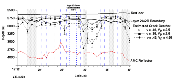
The uncertainty is illustrated in Figure 6, which
shows three estimates of along-strike crack depth variation
for the Spike survey area. Crack depths were derived from
the average crack width (i.e., the average widths of
fissures within bins of 1 minute latitude along-strike;
Figure 3), and based on reasonable combinations of
Poisson's ratios with P-wave velocities (Table 1) in the
calculation of a Young's modulus for equation (1). Figure 6
shows the maximum, median, and minimum crack depths
resulting from the model calculations, therefore giving a
clearer picture of actual uncertainly. Also shown are the
depths to the seafloor, the base of seismic Layer 2A, and
the AMC reflector (Figure 6). The Layer 2A and AMC profiles
are reproduced from the depth profiles of Hooft et
al. [1997] and Mutter et al. [1995]
respectively.
Click on the image for an expanded view
Figure 6.
Estimates of along-strike crack depth
at 17°15'-40'S based on the average widths of
fissures, and using Poisson's ratios of 0.35, 0.48
[Collier and Singh, 1998] and 0.43 [Christeson et
al., 1994; Wright et al., 1995b], and P-wave
velocities of 2.5 and 4.56 km/s [Hussenoeder et al.,
1996]. Errors bars on the depth estimates represent the
standard errors of crack widths (i.e., standard deviations
of the mean). The seafloor profiles are from the Sea Beam
2000 bathymetry of Scheirer et al. [1996b]; the
"Layer 2A/2B Boundary" profiles are from Hooft et
al. [1997]; and the "AMC Reflector" profiles are from
Mutter et al. [1995] and Hooft et al.
[1997]. Vertical exaggeration is 20x.
Shaded vertical bars mark the latitudes of 3rd-order
discontinuities [White et al., 2000], including
discontinuity boundary zones [White et al., 2001].
Dashed vertical lines mark the latitudes of distinct 4th-
order discontinuities, dotted lines the latitudes of
potential 4th-order discontinuities [White et al.,
2001].
The model used predicts crack depths ranging from
~10-400 m below seafloor, and near 17°30’S, where
crack widths are the greatest (as shown in Figure 3), all
of the crack depth estimates penetrate the Layer 2A/2B
boundary. This does not correspond exactly with the
location of the AMC reflector spike or the high-temperature
vents (Figure 7), but is several km to the south of it. It
is interesting to note that some cracks may have resulted
from ponding and drainback of lava, which would have
widened the surface widths of the fissures and resulted in
overestimates of crack depth. Most of the collapse features
in the survey area were identified in Argo II video
records between 17°23-27'S. However, most of the wide
cracks in the 17°30'S region (averaging 8 m in width)
were identified on DSL 120 sonar records and it was very
difficult to distinguish between cracks that may have been
widened due to collapse versus those that were not. The
only region where cracks are not predicted to penetrate the
Layer 2A/2B boundary is just south of the 3rd-order
discontinuity at 17°37’S. Abundant hydrothermal
activity is found immediately to the north and south of
this region (Figure 7). For cracks predicted by the model
to penetrate the Layer 2A/2B boundary, the estimated depths
are considerably greater than those predicted for the EPR
at 9-10°N [Wright et al., 1995b], as well as
those directly observed in the eroded Tertiary and
Pleistocene lava piles of the rift zone in southwest
Iceland [Gudmundsson, 1987; Forslund and
Gudmundsson, 1991].
Discussion
Some Volcanotectonic
Similarities Between the Fast- and Superfast-Spreading
EPR
Several studies [e.g., Macdonald et al.,
1988; Rubin, 1992; Batiza, 1996; Baker and
Urabe, 1996; Haymon, 1996; Head et al.;
1996; Chadwick and Embley; 1998; Curewitz and
Karson, 1998;Fornari et al., 1998] provide
convincing evidence for the dominant role of dike intrusion
and lateral magma transport (over that of a simple far-
field plate stress model) in generating cracks within the
neovolcanic zone at both fast- and superfast-spreading
ridges. Moreover, Haymon [1996] notes the excellent
degree of correlation between magma budget and hydrothermal
flux on both segment and global scales, bolstering the
notion that magma supply exerts primary control on
hydrothermal flux magnitude and vent distribution. However,
at superfast-spreading ridges, the question remains whether
the dike propagation is primarily lateral (from along-
strike magma transport) or vertical (from the greater
abundance/frequency of eruptions in spatially-distributed
areas). The magnitude and distribution of fissuring at
superfast-spreading ridges is largely governed by the
episodic inflation and deflation of the ridge axis due to
variations in dike propagation that may be lateral from a
single injection point over an inflated magma reservoir,
where most of the pre-existing fissures are buried by
recent eruptions.
For example, along the northern EPR at 9-10°N
Wright et al. [1995a] found the mean density of
fissuring on a given 4th-order segment was greater where
relative axial lava age was greater, and that fissure
density also correlated well with hydrothermal vent
abundance and type. It was also found that the widest
cracks (lower in density) occurred in the youngest lavas,
suggesting that these cracks were eruptive in origin and
controlled the locations of high-temperature hydrothermal
venting. It was suggested that in these regions average
fissure widths, and depths (found by Wright et al.
[1995b] to be directly proportional to the widths),
increase due to ridge crest inflation and lateral dike
propagation, resulting from recent magmatic replenishment
of the AMC from upper mantle sources. As was found on the
fast-spreading EPR at 9°-10°N, the most densely
fissured regions in both the Spike and Hump surveys lie
within relatively older (Age 2) terrains while the least
fissured areas coincide with where the freshest lavas are
found (Figure 7). This is particularly the case southward
from the axial depth minimum and AMC reflector spike at
17°25’-29’S, where relative lava ages,
average fissure widths and fissure depths all increase
together along-strike. These observations may be consistent
with a southward propagation of dikes along-strike away
from a focused site of melt injection at 17º 25’-
29’S. A second zone of southward dike propagation may
start within the Stealth segment, between 17°37’S
and 17°39’S, where young, Age 1 axial lavas are
again found (Figures 4 and 7d) as well as wide cracks and
an abundance of hydrothermal activity (Figures 7b and c).
It is surmised that magma migrating south from these
injection sites erupted, pooled, and drained back to create
the wider fissures that are observed, and the very large
fissure depths that we estimate. More than 60% of the
focused hydrothermal vents observed in the area are found
along these wide, deep cracks [O’Neill, 1998;
O’Neill et al., 1998], which is similar to what
was observed at 9-10°N where cracks are also
widest/deepest in regions of eruption and venting.
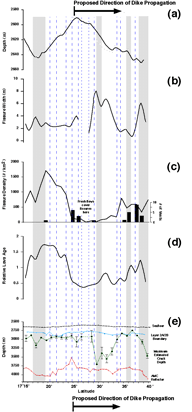
|
Figure 7.
Stacked plots (versus latitude) of
axial topography, average fissure width, fissure density
(overlain with focused hydrothermal flow), relative axial
lava age, and estimated fissure depth for the southern EPR
crest, 17°15'-40'S. Shaded vertical bars mark the
latitudes of 3rd-order discontinuities [White et
al., 2000], including discontinuity boundary zones
[White et al., 2001]. Dashed vertical lines mark the
latitudes of distinct 4th-order discontinuities, dotted
lines the latitudes of potential 4th-order discontinuities
[Haymon et al., in prep.]. (a) Smoothed axial depth
profile of the ridge axis, from the Sea Beam 2000 data of
Scheirer et al. [1996b]. Vertical exaggeration is
50x. (b) Interpolated profile of average and fissure width
measured within bins of 1 minute of latitude along-strike.
(c) Along-strike variation in fissure density. Argo
II observations of focused hydrothermal flow (i.e.,
high-temperature smokers and smoke plumes) are overlain for
comparison [Haymon et al., 1997; O'Neill et
al., 1998]. (d) Along-strike variation in relative
axial lava age averaged within bins of 1 minute of latitude
along-strike (data from Haymon et al. [in prep.]).
(e) Maximum, estimated along-strike variation in crack
depth from Figure 6. The "Seafloor" and "Layer 2A/2B
Boundary" profiles are also the same as in Figure 6. Error
bars represent the standard errors. Vertical exaggeration
is 20x.
Click on the image for an expanded
view
|
The numerical modeling of Head et al. [1996]
shows that typical dike widths for the MOR should range
from ~0.2 m to ~3 m. Field observations at Hess Deep
[Francheteau et al., 1992; Karson et al.,
1992 and 1999] and in the Oman ophiolite [MacLeod and
Rothery, 1992] suggest that dikes along fast-spreading
ridges are indeed within this range, at 1 m. The
experiments of Mastin and Pollard
[1988] demonstrate that the top of a dike must be shallower
than about ten times its thickness at its top in order to
generate fissures. Head et al. [1996] find that
dikes in the range of 0.2-3 m thickness will cause
fissuring at the surface only if they penetrate to depths
of less than a few tens of meters. Dikes greater in
thickness may be able to produce fissuring from much
greater depths, given that the ambient stress at depth is
near the level required for tensile failure. To wit, the
dike propagation model of Pollard et al. [1983] for
the 1976 Krafla fissure eruptions in Iceland, places a dike
of thickness _ 2 m at a depth of 250 m. The ambient
stress at this depth must be near the level required for
tensile failure of the crust (~30 MPa) in order for
fissures to form above the dike at the surface
[Wright, 1998]. Our estimates of fissure depth for
the Spike survey area (mean depth of ~300 + 60 m;
Figure 6) therefore imply the presence of a number of
failed dikes that were emplaced much deeper than predicted
by the Mastin and Pollard [1988] model, and may be
of thicknesses in excess of 2-3 m. Preliminary confirmation
of this has been found at Aldo Lake with Autonomous Benthic
Explorer (ABE) magnetic and bathymetric data of Cormier
et al. [1999]. In addition, Cornier et al.
[1999] noted that the lips of a 20-50-m-wide, 200-500-m-
long eruptive fissure in Aldo Lake, were at a constant
depth throughout, indicating that the magma rose to the
same head everywhere from a well-connected magma source
along-axis. If southern EPR fissures are unconstrained by
either the upper surface of the dike [Rubin and
Pollard, 1987; Rubin, 1992] or the compressive
stress field that forms normal to the dike (as was found
for TAG fissures by Bohnenstiehl and Kleinrock
[2000]), they may be forming in front of laterally
propagating dikes. It should be noted that the Krafla event
in Iceland, although involving dike emplacement at similar
depths, was unusually voluminous, resulting in a zone of
fissuring and faulting ~6 km wide [Sigurdsson,
1980], much larger than a typical neovolcanic zone on the
MOR. However, Curewitz and Karson [1998] surmise
that the intrusion of even a single 1-m-dike on a fast-
spreading ridge should affect an area larger than the width
of the axial region, though narrower than typical rift
valleys at slow-spreading ridges.
As was observed at 9-10°N, positive correlation of
fissure density with relative ages of axial lavas in the
Spike area (Figure 4) reveals the tendency of the crust in
the axial zone to accumulate more cracks with time rather
than to widen existing cracks [Wright et al.,
1995a]. This implies that the formation of wide, deep
cracks is intimately related to episodes of dike intrusion,
the possibility of dike propagation that is lateral, the
eruption of fresh, uncracked flows, and hydrothermal
venting. Due to the greater frequency of eruptions at
superfast-spreading ridges, many of which are probably
short-lived [Sinton et al., 1999], lateral
propagation may not necessarily extend as far along-strike
(i.e., for tens of km), as has been postulated for
intermediate centers [e.g., Chadwick and Embley,
1998]. As intrusions and eruptions wane, magma drainback
leads to the production of subcrustal voids, which help to
collapse the crustal carapace and bring the onset of
crustal cooling and extension [e.g., as described by
Engels, 2001]. This in turn produces additional
smaller, shallower cracks in the frozen volcanic carapace
overlying the sheeted dikes.
Some Volcanotectonic Differences Between the Fast-
and Superfast-Spreading EPR
Assuming that the mechanics of fracturing are
the same at both the northern and southern EPR and that
both are inflated sections of ridge (e.g., as evidenced by
similarly large cross-sectional areas; Scheirer and
Macdonald [1992]), it is interesting to note several
volcanotectonic differences between the two as evidenced by
our data. In other words, processes do not necessarily
remain the same as the spreading rate is scaled up.
For instance, along the EPR at 9-10°N Wright et
al. [1995a] found a reasonably clear demarcation
between ridge segments dominated by tectonic cracks vs.
eruptive fissures. While eruptive fissures cannot be
unequivocally distinguished from those of purely tectonic
origin using the Argo II images, fissures south of
17°25’S within the Spike survey area may indeed
be eruptive in origin, due to the strong correlation of
wide fissures in relatively young lava flows (Figures 4 and
7). Purely tectonic fissures, accumulated on-axis in
relatively older lava flows, would become wider as they
move off-axis, due to accumulated extension over time. Most
of the fissures in the Spike survey area appear to
penetrate the Layer 2A/2B boundary (Figures 6 and 7) and
are thus deep enough to tap melt and serve as loci for
high-temperature hydrothermal discharge above dike
intrusions (subject to tensile stresses opening pathways
for hydrothermal flow ahead of and above a laterally
propagating dike tip, as mentioned earlier). It is not
evident that the narrowest fissures observed in this region
have all formed in response to crustal extension and/or
thermal contraction, because a good proportion of them, in
addition to extending well into Layer 2B occur in
relatively young flows, Age 0.5 to Age 1(Figures 4 and 7).
This is not to imply, however, that it is impossible for a
fissure at a superfast-spreading ridge to be tectonic in
origin if it penetrates the Layer 2A/2B boundary.
Gudmundsson and Bäckstrom [1991] have shown
that a tectonic crack may extend as far as 500-800 m into
the crust before developing into a normal fault. In
contrast, observational evidence gathered at 9-10°N
shows an abundance of narrower, shallower fissures in
relatively older lava flows to be primarily tectonic,
forming primarily within Layer 2A [Wright et al.,
1995a and b]. Also, within the Spike area there is no clear
demarcation between older lavas to the north or south of an
axial high. For example, Figure 4 shows many pockets of
relatively old Age 2 lavas sandwiched in between lavas of
Age 1 and 1.5 throughout the Spike survey region. Eruptions
at superfast-spreading rates may be occurring in multiple
segments all at once (along with the intrusion of many non-
eruptive dikes), so that a clear demarcation between older
segments with abundant tectonic cracks and younger segments
dominated by eruptive fissuring would be difficult to
detect.
An interesting observation is that while the most
densely fissured regions in both the Spike and Hump survey
areas lie within relatively older (Age 2) terrains, the
Spike region throughout has fissure densities far
surpassing those of the northern EPR (Figure 5). This
suggests that the relative lava ages within the surveyed
zone of the southern EPR crest are older on average than
the lava ages within the surveyed zone along the northern
EPR. Because we are observing relative, rather than
absolute, lava ages in both areas, we cannot test this
hypothesis directly. However, we note in this context that
lava flow morphology observations in the two areas reveals
a much higher percentage of lobate and sheet flows relative
to pillow flows along the northern EPR in comparison to the
southern EPR [White et al., 2000; White et
al., submitted]. This is consistent with the much
greater extent along-strike of axial summit collapse
troughs along the EPR at 9º-10ºN, from which many
lobate and sheet flows are emanating [Fornari et
al., 2000; Kurras et al., 2000; White et
al., submitted]. We therefore postulate that a larger
portion of the surveyed area on the northern EPR is covered
by relatively young and uncracked lobate and sheet flows
which are areally extensive, in comparison to the surveyed
area on the southern EPR crest which includes more areally-
restricted pillow lava flows that are on average older and
hence more fissured. In fact a key difference between fast
and super-fast spreading ridges may be the greater
abundance/frequency of dikes at super-fast ridges on a
time-integrated basis, which may also help to explain the
relative abundance of pillow lavas on the southern EPR. Due
to the greater frequency of eruptions at superfast
spreading rates, there may be a greater percentage of dikes
that do not make it to the surface; and what dikes do reach
the surface may have less magmatic head, resulting in
eruptions that are less effusive, particularly at the ends
of 3rd-order segments.
Another possible factor is that within the Spike survey
area Layer 2A is quite thin at the ridge axis [Carbotte
et al., 1997; White et al., 2000].
White et al. [2000] have noted that this is the
case because the axial high here is an isostatic rise
instead of a constructional volcanic ridge. A thinner crust
at superfast spreading rates may cause cracking events to
accelerate and propagate much farther, which would increase
crack density, and also could activate multiple fine-scale
segments at once. For example, the average Layer 2A
thickness along the axis in the Spike survey area is ~25%
thinner than it is on the EPR axis at 9º-10ºN
(~140 m; Figure 6), compared to ~175 m at EPR 9.5ºN
[Christeson et al., 1994]. Fissures at superfast-
spreading rates may form and move so quickly from the
leading edge of a laterally propagating dike that they are
not constrained by segment boundaries, as they are at fast-
spreading rates.
Haymon et al. [1991] and Wright et al.
[1995a] have shown how the structure of a fast-spreading
ridge crest is related to both magmatic and tectonic
processes that may be episodically cyclic within a
2nd-, 3rd- or 4th-order segment. The model of Haymon et
al. [1991] for 9-10°N describes individual 4th-
order segments in different phases of a volcanic-
hydrothermal-tectonic cycle on a 100-1000 year timescale,
beginning with episode(s) of cracking/diking and eruptive
fissuring, followed by magmatic drainback, gravitational
collapse, possible development of an AST, and then cooling
of the heat source, initiation of tectonic fissuring, and
waning of hydrothermal and magmatic activity.
It is not evident that along-strike variability in
crustal fissuring corresponds as closely to the fine-scale
morphotectonic segmentation of the ridge crest as on the
northern EPR at 9-10°N, where fine-scale segment
boundaries coincide almost exactly with along-strike
changes in the mean density of fissuring, in relative ages
of axial lavas, and also in hydrothermal vent abundance
[Haymon et al., 1991; Wright et al., 1995].
White et al. [2000] found systematic changes in
volcanic morphology at the 3rd-order scale, and proposed
that each 3rd-order segment physically behaves as a single
volcanic system, with higher effusion rates near segment
centers, and lower effusion rates near segment ends. Why
the volcanic expression does not translate to clear
signatures in crustal fissuring remains unclear. Rubin
et al. [2001] have found that the chemical
heterogeneity of lavas at 17°26'-27'S is indicative of
a fissure eruption with an initially slow effusion rate,
followed by a much higher effusion rate near the end. They
surmise that the last phase of the eruption may have
covered most of the lavas initially erupted, making it
difficult to distinguish between along-axis compositional
patterns and zonations within the flow [Rubin et
al., 2001]. So perhaps what distinct signatures there
may be in the variability of fissuring at fine-scale
segment boundaries are constantly being covered by new
flows.
Summary and
Conclusions
- As was found on the
fast-spreading EPR at 9-10°N, the most densely
fissured regions within the Spike survey area
(17°15’-40’S) lie within relatively older
(Age 2) terrains. In contrast, the least fissured areas
coincide with where the freshest lavas are found. The
positive correlation of fissure density with relative ages
of axial lavas in the Spike survey area reveals the
tendency of the crust in the axial zone to accumulate more
cracks with time rather than to widen and deepen existing
cracks [Wright et al., 1995a]. This implies that the
formation of wide, deep cracks is intimately related to
episodes of dike intrusion, perhaps the lateral propagation
of dikes, the eruption of fresh, uncracked flows, and
hydrothermal venting. As intrusions and eruption wane,
crustal cooling and extension produce additional smaller,
shallower cracks in the frozen volcanic carapace overlying
the sheeted dikes.
- The majority of fissures along the Spike survey area
may be generated by dike intrusions. At superfast-spreading
ridges, our data appears to support dike intrusion and then
lateral propagation rather than vertical injection from a
greater abundance/frequency of eruptions in spatially-
distributed areas). Many fissures are estimated to
penetrate the Layer 2A/2B boundary and thus be deep enough
to tap melt in places, and serve as loci for high-
temperature hydrothermal discharge above the intrusions.
There may be two major zones of lateral dike propagation
from local sites of melt injection: one extending southward
through the Aldo Lake and Tubeworm segments, from
17°25’S down to 17°34’S, and a second
zone that starts just to the south within the Stealth
segment, between 17°37’ and 17°39’S.
The focused hydrothermal flow is most abundant at the north
ends of both of these zones.
- The density of fissuring in the Spike area on the
southern EPR is significantly higher than it is on the EPR
at 9º-10ºN. Independent observations of lava flow
morphology in these two areas by Kurras et al.
[2000] and White et al. [2000 and submitted] have
demonstrated that there are comparatively more extensive
lobate and sheet flows along the EPR crest at 9º-
10ºN (i.e., lobate flows are the most abundant, but
the relative percentage of area covered by sheet flows is
higher along the EPR). These flows emanate from the axial
summit collapse troughs found along most of the axial zone
in this region. We suggest that these rather young,
uncracked lobate and sheet flows are responsible for lower
fissure density here in comparison to the Spike area on the
southern EPR, where less effusive pillow flows of greater
average lava age and higher fissure density are more common
(in other words, the higher fissure density on the southern
EPR fits well in explaining both the higher extensional
rate and more frequent occurrence of pillow flows).
- A distinct signature in crustal fissuring at a 3rd-
versus a 4th-order scale along superfast-spreading
ridges (as compared to fast-spreading ridges) is not
evident. Thinner crust at superfast spreading ridges may
cause cracking events to propagate farther and affect
multiple fine-scale segments at once, so that a 2nd-order
scale response is observed rather than a finer-scale 3rd-
or 4th-order signal. A greater frequency of diking and
eruption (i.e., rapid, reconfiguration at shorter length
and time scales) may create superpositions of distributions
that are more difficult to deconvolve. Therefore it is may
be more difficult to detect volcanic-hydrothermal-tectonic
cycling (with fissure data at least) at superfast-spreading
rates, where volcanism is playing a much larger role in
controlling seafloor morphology.
Acknowledgements.The
Argo II and DSL-120 technical groups of the
Deep Submergence Laboratory, Woods Hole Oceanographic
Institution, as well as Captain Eric Buck and the crew of the R/V
Melville, and all the participants of the Sojourn 2
expedition are gratefully acknowledged for their
enthusiastic help and cooperation. Dan Scheirer,
Yves Lagabrielle, and Milene Cormier are thanked for helpful
discussions. We thank Dan Scheirer for processing the Imagenex data for
us. The very careful and thoughtful reviews of Dan Fornari, an
associate editor, and an anonymous reviewer significantly improved
the manuscript. DJW was supported by NSF grant OCE-9521039, and
RMH, SMW, and KCM by NSF/OCE-9416996 and NSF/OCE-9816021.
References
BACK TO TOP
Auzende, J.-M., V.
Ballu, R. Batiza, D. Bideau, J.-L. Charlou, M.-H. Cormier,
Y. Fouquet, P. Geistodoerfer, Y. Lagabrielle, J. Sinton,
and P. Spadea, Recent tectonic, magmatic, and hydrothermal
activity on the East Pacific Rise between 17°S and
19°S: Submersible observations, J. Geophys.
Res., 101 , 17,995-18,010, 1996.
Backer, H., J. Lange, and V. Marchig,
Hydrothermal activity and sulfide formation in axial
valleys of the East Pacific Rise crest between 18 and 22°S,
Earth Planet. Sci. Lett., 72, 9-22, 1985.
Baker, E.T., and T. Urabe, The distribution of
hydrothermal venting along the superfast-spreading East
Pacific Rise, 13°30'-18°40'S, J. Geophys.
Res., 101, 8685-8695, 1996.
Ballard, R.D., and J. Francheteau, The relationship
between active sulfide deposition and the axial processes
of the mid-ocean ridge, Mar. Tech. Soc. J.,
16, 8-20, 1982.
Batiza, R., Magmatic segmentation of mid-ocean ridges: A
review, in Tectonic, Magmatic, Hydrothermal and
Biological Segmentation of Mid-Ocean Ridges, Geol.
Soc. Spec. Publ. 118, edited by C.J. MacLeod, P.A.
Tyler, and C.L. Walker, 103-130, 1996.
Bohnenstiehl, D.R., and M.C. Kleinrock, Fissuring near
the TAG active hydrothermal mound, 26°N on the Mid-
Atlantic Ridge, J. Volcanol. Geotherm. Res.,
98, 33-48, 2000.
Bowen, A., D. Fornari, J. Howland, and B. Walden, The
Woods Hole Oceanographic Institution's Remotely-operated
and Towed Vehicle Facilities for Deep Ocean Research, Woods
Hole Oceanographic Institution, Woods Hole, Massachusetts,
1993.
Carbotte, S.M., J.C. Mutter, and L. Xu, Contribution of
volcanism and tectonism to axial and flank morphology of
the southern East Pacific Rise, 17°10’-
17°40’S, from a study of layer 2A geometry, J.
Geophys. Res., 102 , 10,65-10,184, 1997.
Chadwick, W.W., Jr., and R.W. Embley, Graben formation
associated with recent dike intrusions and volcanic
eruptions on the mid-ocean ridge, J. Geophys. Res.,
103, 9807-9826, 1998.
Christeson, G.L., G.M. Purdy, and G.J. Fryer, Seismic
constraints on shallow crustal emplacement processes at the
fast-spreading East Pacific Rise, J. Geophys. Res.,
99, 17,957-17,996, 1994.
Christeson, G.L., P.R. Shaw, and J.D. Garmany, Shear and
compressional wave structure of the East Pacific Rise,
9°-10°N, J. Geophys. Res., 102 ,
7821-7836, 1997.
Collier, J.S., and S.C. Singh, Poisson’s ratio
structure of young oceanic crust, J. Geophys. Res.,
103 , 20,981-20,996, 1998.
Cormier, M.-H., and K.C. Macdonald, East Pacific Rise
18°-19°S: Asymmetric spreading and ridge
reorientation by ultrafast migration of axial
discontinuities, J. Geophys. Res., 99 , 543-
564, 1994.
Cormier, M.-H., D.S. Scheirer, and K.C. Macdonald,
Evolution of the East Pacific Rise at 16°-19°S
since 5 Ma: Bisection of overlapping spreading centers by
new, rapidly propagating ridge segments, Mar. Geophys.
Res., 18 , 53-84, 1996.
Cormier, M.-H., W.B.F. Ryan, W. Jin. A. Shah, A.M.
Bradley, D.R. Yoerger, H. Singh, J. Sinton, R. Batiza, and
K. Rubin, Building of the extrusive crust of the EPR at 17
28'S through fissure-fed inflationary lava flows
(abstract), Eos, Trans. AGU, 80, F1097, 1999.
Crane, K., Structural evolution of the East Pacific Rise
axis from 13°10’N to 10°35’N:
Interpretations from SeaMARC I data, Tectonophysics,
136, 65-124, 1987.
Curewitz, D., and J.A. Karson, Geological consequences
of dike intrusion at mid-ocean ridge spreading centers, in
Faulting and Magmatism at Mid-Ocean Ridges, edited
by W.R. Buck, P. Delaney, J.A. Karson, and Y. Lagabrielle,
117-136, American Geophysical Union, Washington, D. C.,
1998.
DeMets, C., R.G. Gordon, D.F. Argus, and S. Stein,
Effect of recent revisions to the geomagnetic reversal time
scale on estimates of current plate motions, Geophys.
Res. Lett., 21 , 2191-2194, 1994.
Detrick, R.S., A.J. Harding, G.M. Kent, J.A. Orcutt, and
J.C. Mutter, Seismic structure of the southern East Pacific
Rise, Science, 259, 499-503, 1993.
Dziak, R.P., C.G. Fox, and A.E. Schreiner, The June-July
1993 seismo-acoustic event at CoAxial segment, Juan de Fuca
Ridge: Evidence for a lateral dike injection, Geophys.
Res. Lett., 22 , 135-138, 1995.
Embley, R. W., Geologic, chemical, and biological
evidence for recent volcanism at 17.5°S: East Pacific
Rise. Earth and Planetary Science Letters 163:131-
147, 1998.
Engels, J., Collapse of Seafloor Volcanic Terrain: A
Key Process in the formation of the Upper Oceanic
Crust, Master's thesis, University of Hawai'i,
Honolulu, Hawai'i, 2001.
Fialko, Y., On origin of near-axis volcanism and
faulting at fast spreading mid-ocean ridges, Earth
Planet. Sci. Lett., 190, 31-39, 2001.
Fornari, D.J., R.M. Haymon, M.R. Perfit, T.K.P. Gregg,
and M.H. Edwards, Axial summit trough of the East Pacific
Rise 9°-10°N: Geological characteristics and
evolution of the axial zone of fast spreading mid-ocean
ridges, J. Geophys. Res., 103 , 9827-9856,
1998.
Fornari, D., M. Perfit, M. Tolstoy, R. Haymon, D.
Scheirer, P. Johnson, G. Kurras, S. White, and J. Getsiv,
2000, AHA-NEMO2, Shipboard data web site compiled during
R/V Melville NEMO expedition, Leg 2, WHOI,
ahanemo2.whoi.edu,
2000.
Forslund, T., and A. Gudmundsson, Crustal spreading due
to dikes and faults in southwest Iceland, J. Struct.
Geol., 13, 443-457, 1991.
Francheteau, J., R. Armijo, J.-L. Cheminée, R.
Hékinian, P. Lonsdale, and N. Blum, Dyke complex of
the East Pacific Rise exposed in the walls of Hess Deep and
the structure of the upper oceanic crust, Earth Planet.
Sci. Lett., 111, 109-121, 1992.
Fujioka, K., and et al. MODE ’94: Active
hydrothermal systems of a super-fast spreading ridge,
southern East Pacific Rise (13°58’S to
18°26’S). InterRidge News 4:7-10,
1995.
Garel, E., O. Dautiel, and Y. Lagabrielle, Deformation
processes at fast to ultra-fast oceanic spreading axes:
Mechanical approach, Tectonophysics, submitted,
2001.
Gripp, A.E., and R.G. Gordon, Current plate velocities
relative to the hot spots incorporating the NUVEL-1 plate
motion model, Geophys. Res. Lett., 17, 1109-
1112, 1990.
Gudmundsson, A., Tectonics of the Thingvellir fissure
swarm, SW Iceland, J. Struct. Geol., 9, 61-
69, 1987.
Gudmundsson, A., Emplacement of dikes, sills, and
crustal magma chambers at divergent plate boundaries,
Tectonophysics, 176, 257-275, 1990.
Gudmundsson, A., Formation and growth of normal faults
at the divergent plate boundary in Iceland, Terra
Nova, 4, 464-471, 1992.
Gudmundsson, A., and K. Bäckström, Structure
and development of the Sveinagja Graben, Northeast Iceland,
Tectonophysics , 200, 111-125, 1991.
Haimson, B.C., and F. Rummel, Hydrofracturing stress
measurements in the Iceland research drilling project drill
hole at Reydarfjördur, Iceland, J. Geophys.
Res., 87 , 6631-6649, 1982.
Haymon, R.M., The response of ridge-crest hydrothermal
systems to segmented, episodic magma supply, in
Tectonic, Magmatic, Hydrothermal and Biological
Segmentation of Mid-Ocean Ridges, Geol. Soc. Spec.
Publ. 118, edited by C.J. MacLeod, P.A. Tyler, and C.L.
Walker, 157-168, 1996.
Haymon, R.M., D.J. Fornari, M.H. Edwards, S. Carbotte,
D. Wright, and K.C. Macdonald, Hydrothermal vent
distribution along the East Pacific Rise Crest
(9°09’-54’N) and its relationship to
magmatic and tectonic processes on fast-spreading mid-ocean
ridges, Earth Planet. Sci. Lett., 104, 513-
534, 1991.
Haymon, R.M., K.C. Macdonald, S. Baron, L. Crowder, J.
Hobson, P. Sharfstein, S. White, B. Bezy, E. Birk, F.
Terra, D. Scheirer, D.J. Wright, L. Magde, C. Van Dover, S.
Sudarikov, and G. Levai, Distribution of fine-scale
hydrothermal, volcanic, and tectonic features along the EPR
crest, 17°15’-18°30’S: Results of near-
bottom acoustic and optical surveys (abstract), Eos,
Trans. AGU, 78 , F705, 1997.
Head, J.W., III, L. Wilson, and D.K. Smith, Mid-ocean
ridge eruptive vent morphology and substructure: Evidence
for dike widths, eruption rates, and evolution of eruptions
and axial volcanic ridges, J. Geophys. Res.,
101, 28,265-28,280, 1996.
Hey, R.N., P.D. Johnson, F. Martinez, J. Korenaga, M.L.
Somers, Q.J. Huggett, T.P. LeBas, R.I. Rusby, and D.F.
Naar, Plate boundary reorganization at a large-offset,
rapidly propagating rift, Nature, 378, 167-
170, 1995.
Hooft, E.E.E., R.S. Detrick, and G.M. Kent, Seismic
structure and indicators of magma budget along the Southern
East Pacific Rise, J. Geophys. Res., 102 ,
27,319-27,340, 1997.
Hussenoeder, S.A., J.A. Collins, G.M. Kent, R.S.
Detrick, and T. Group, Seismic analysis of the axial magma
chamber reflector along the southern East Pacific Rise from
conventional reflection profiling, J. Geophys. Res.,
101 , 22,087-22,106, 1996.
Ito, H. Development of a borehole televiewer digital
data acquisition system and fracture system observed in the
Tanna Basin, Geological Survey of Japan Report,
282, 297-316, 1995.
Jaeger, J. C., and N. G. W. Cook, Fundamentals of
Rock Mechanics, 3rd edition, Chapman and Hall, London,
1979.
Johnson, H.P., and B.L. Salem, Magnetic properties of
dikes from the oceanic upper crustal section, J.
Geophys. Res., 99 , 21, 733-21,740, 1994.
Karson, J.A., S.D. Hurst, and P. Lonsdale, Tectonic
rotations of dikes in fast-spread oceanic crust exposed
near Hess Deep, Geology, 20, 685-692,
1992.
Karson, J.A., E.M. Klein, and S.D. Hurst, Internal
structure of uppermost fast-spread oceanic crust of the
East Pacific Rise exposed at the Hess Deep rift: Results
from Alvin, Argo II, and DSL 120 investigations (abstract),
Eos, Trans. AGU, 80, F983-F984, 1999.
Krammer, A., P. Pezard, P. Harvey, K.H. Peter, and K.
Fuchs, Borehole televiewer data analysis of Hole 504B from
legs 137 and 140, Proceedings of the Ocean Drilling
Program, Scientific Results, 137/140, 293-304,
1995.
Kurras, G.J., D.J. Fornari, M.H. Edwards, M.R. Perfit,
and M.C. Smith, Volcanic morphology of the East Pacific
Rise crest 9°49'-52': Implications for volcanic
emplacement processes at fast-spreading mid-ocean ridges,
Mar. Geophys. Res., 21 (1/2), 23-41,
2000.
Lachenbruch, A. H. 1961. Depth and spacing of tension
cracks. Journal of Geophysical Research, 66,
4273-4292.
Lachenbruch, A.H., A simple mechanical model for oceanic
spreading centers, J. Geophys. Res., 78 ,
3395-3417, 1973.
Lagabrielle, Y., and M.-H. Cormier, Formation of large
summit troughs along the East Pacific Rise as collapse
calderas: An evolutionary model, J. Geophys. Res.,
104 , 12,971-12,988, 1999.
Lin, J., and E.M. Parmentier, Mechanisms of lithospheric
extension at mid-ocean ridges, Geophys. J.,
96, 1-22, 1989.
Lonsdale, P., Segmentation of the Pacific-Nazca
spreading center, 1°N-20°S, J. Geophys.
Res., 94 , 12,197-12,225, 1989.
Lowell, R.P., and L.N. Germanovich, Dike injection and
the formation of megaplumes at ocean ridges,
Science, 267, 1804-1807, 1995.
Macdonald, K. C. and P. J. Fox, The axial summit graben
and cross-sectional shape of the East Pacific Rise as
indicators of axial magma chambers and recent volcanic
eruptions, Earth Planet. Sci. Lett., 88, 119-131,
1988.
Macdonald, K.C., P.J. Fox, L.J. Perram, M.F. Eisen, R.M.
Haymon, S.P. Miller, S.M. Carbotte, M.-H. Cormier, and A.N.
Shor, A new view of the mid-ocean ridge from the behaviour
of ridge-axis discontinuities, Nature, 335,
217-225, 1988.
Macdonald, K. C., D. S. Scheirer, and S. M. Carbotte,
Mid-ocean ridges: Discontinuities, segments and giant
cracks, Science, 253, 986-994, 1991.
MacLeod, C.J., and D.A. Rothery, Ridge axial
segmentation in the Oman ophiolite: Evidence from along-
strike variations in the sheeted dike complex, in
Ophiolites and Their Modern Analogues, Geol. Soc.
Spec. Publ. 60, edited by L.M. Parson, B.J. Murton, and
P. Browning, 39-63, 1992.
Magde, L. S., R. S. Detrick, and T. Group, Crustal and
upper mantle contribution to the axial gravity anomaly at
the southern East Pacific Rise. Journal of Geophysical
Research 100, 3747-3766, 1995.
Marchig, V., J. Erzinger, and P.-M. Heinze, Sediment in
the black smoker area of the East Pacific Rise (18.5°S),
Earth Planet. Sci. Lett., 79, 93-106, 1986.
Mastin, L.G., and D.D. Pollard, Surface deformation and
shallow dike intrusion processes at Inyo Craters, Long Valley,
California, J. Geophys. Res., 93, 13,221-13,235, 1988.
Mutter, J.C., S.M. Carbotte, W. Su, L. Xu, P. Buhl, R.S.
Detrick, G.M. Kent, J.A. Orcutt, and A.J. Harding, Seismic
images of active magma systems beneath the East Pacific
Rise between 17° 05’ and 17°35’S,
Science, 268 , 391-395, 1995.
Naar, D.F., and R.N. Hey, Recent Pacific-Easter-Nazca
plate motions, in Evolution of Mid Ocean Ridges,
edited by J.M. Sinton, American Geophysical Union,
Washington, D.C., 9-30, 1989.
O'Neill, J.H., Geologic Controls on Distribution of
Hydrothermal Vents on the Superfast-Spreading Southern East
Pacific Rise, Master’s Thesis, University of
California, Santa Barbara, California, 1998.
O'Neill, J.H., R.M. Haymon, K.C. Macdonald, and S.M.
White, Hydrothermal vents at 17° 25'S and 17°
37'S on the superfast-spreading EPR (abstract), Eos,
Trans. AGU, 79, F817, 1998.
Perram, L.J., M.-H. Cormier, and K.C. Macdonald,
Magnetic and tectonic studies of the dueling propagating
spreading centers at 20°40’S on the East Pacific
Rise: Evidence for crustal rotations, J. Geophys.
Res., 98 , 13,835-13,850, 1993.
Pollard, D.D., P.T. Delaney, W.A. Duffield, E.T. Endo,
and A.T. Okamura, Surface deformation in volcanic rift zones,
Tectonophysics, 94, 541-584, 1983.
Renard, V., R. Hekinian, J. Francheteau, R.D. Ballard,
and H. Bäcker, Submersible observations at the axis of
the ultra-fast-spreading East Pacific Rise
(17°30’ to 21°30’S), Earth Planet.
Sci. Lett., 75, 339-353, 1985.
Rubin, A.M., Dike-induced faulting and graben subsidence
in volcanic rift zones, J. Geophys. Res., 97
, 1839-1858, 1992.
Rubin, A.M., and D.D. Pollard, Origins of blade-like
dikes in volcanic rift zones, in Volcanism in
Hawaii, edited by R.W. Decker, T.L. Wright, and P.H.
Stauffer, U.S. Geological Survey, Denver, Colorado, 1449-
1470, 1987.
Rubin, K.H., M.C. Smith, E.C. Bergmanis, M.R. Perfit,
J.M. Sinton, and R. Batiza, Geochemical heterogeneity
within mid-ocean ridge lava flows: Insights into eruption,
emplacement and global variations in magma generation,
Earth Planet. Sci. Lett., 188 (3-4), 349-367,
2001.
Scheirer, D.S., and K.C. Macdonald, Variation in cross-
sectional area of the axial ridge along the East Pacific
Rise: Evidence for the magmatic budget of a fast-spreading
center, J. Geophys. Res., 98 , 7871-7886,
1993.
Scheirer, D.S., K.C. Macdonald, D.W. Forsyth, S.P.
Miller, D.J. Wright, M.-H. Cormier, and C.M. Weiland, A map
series of the southern East Pacific Rise and its flanks,
15°S to 19°S, Mar. Geophys. Res.,
18 , 1-12, 1996a.
Scheirer, D.S., M. Cormier, K.C. Macdonald, R.M. Haymon,
and S. White, Sojourn Leg 1: Completing the picture of the
East Pacific Rise and its flanks in the MELT area
(abstract), Eos, Trans. AGU, 77, F663,
1996b.
Scheirer, D.S., D.W. Forsyth, M.-H. Cormier, and K.C.
Macdonald, Shipboard geophysical indications of asymmetry
and melt production beneath the East Pacific Rise near the
MELT experiment, Science, 280, 1221-1224,
1998.
Scheirer, D.S., D.J. Fornari, S.E. Humphris, and S.
Lerner, High-resolution seafloor mapping using the DSL-120
sonar system: Quantitative assessment of sidescan and
phase-bathymetry data from the Lucky Strike segment of the
Mid-Atlantic Ridge, Mar. Geophys. Res., 21
(1/2), 121-142, 2000.
Shah, A., M.-H. Cormier, W.B.F. Ryan, W. Jin, A.M.
Bradley, and D.R. Yoerger, High resolution 3-D map of the
Earth's magnetic field at the EPR reveals dike outcrops and
large-scale void space in extrusive layer (abstract),
Eos, Trans. AGU, 80, F1074, 1999.
Shaw, P.R., Age variations of oceanic crust Poisson's
ratio: Inversion and a porosity evolution model, J. Geophys.
Res., 99, 3057-3066, 1994.
Sigurdsson, O., Surface deformation of the Krafla fissure
swarm in two rifting events, J. Geophys., 47, 154-159, 1980.
Sinton, J.M., S.M. Smaglik, J.J. Mahoney, and
K.C. Macdonald, Magmatic processes at superfast spreading
oceanic ridges: Glass compositional variations along the
East Pacific Rise, 13ˇ-23ˇ°S, J. Geophys. Res.,
96, 6133-6155, 1991.
Sinton, J., E. Bergamis, R. Batiza, K. Rubin, T. K. P.
Gregg, K. Grönvold, S. White, K. Macdonald, C. Van
Dover, M.-H. Cormier, W. Ryan, M. Aigner-Torres, L. Popels,
E. Boyle, A. Shah, and W. Jin, Volcanological
investigations at superfast spreading: Results from R/V
Atlantis Cruise 3-31. RIDGE Events
10:17-23, 1999.
Tada, H., P. C. Paris, and G. R. Irwin, The Stress
Analysis of Cracks Handbook. Hellertown, Pennsylvania:
Del Research Corporation, 1973.
Urabe, T., E. T. Baker, J. Ishibashi, R. A. Feely, K.
Marumo, G. J. Massoth, A. Maruyama, K. Shitashima, K.
Okamura, J. E. Lupton, A. Sonada, T. Yamazaki, M. Aoki, J.
Gendron, R. Greene, Y. Kaiho, K. Kisimoto, G. Lebon, T.
Matsumoto, K. Nakamura, A. Nishizawa, O. Okano, G. Paradis,
K. Roe, T. Shibata, D. Tennant, T. Vance, S. L. Walker, T.
Yabuki, and N. Ytow, The effect of magmatic activity on
hydrothermal venting along the superfast-spreading East
Pacific Rise. Science 269, 1092-1095,
1995.
White, S. M., K.C. Macdonald, and R.M. Haymon, Basaltic
lava domes, lava lakes, and volcanic segmentation on the
southern East Pacific Rise, J. Geophys. Res.,
105, 23,519-23,536, 2000.
White, S.M., R. Haymon, K. Macdonald, Hydrothermal and
volcanic response to fine-scale segmentation of the East
Pacific Rise, Eos, Trans. AGU, 82(47), Fall Meet.
Suppl., Abstract T12A-9096, F1114, 2001.
White, S. M., R. M. Haymon, D. J. Fornari, M. R. Perfit,
and K. C. Macdonald, Correlation between volcanic and
tectonic segmentation at fast spreading ridges: Evidence
from volcanic structures and lava flow morphology on the
East Pacific Rise, 9°-10°N, J. Geophys.
Res., submitted.
Wright, D.J., Formation and development of fissures at
the East Pacific Rise: Implications for faulting and
magmatism at mid-ocean ridges, in Faulting and Magmatism
at Mid-Ocean Ridges, edited by W.R. Buck, P. Delaney,
J.A. Karson, and Y. Lagabrielle, American Geophysical
Union, Washington, D. C., 137-151, 1998.
Wright, D.J., R.M. Haymon, and D.J. Fornari, Crustal
fissuring and its relationship to magmatic and hydrothermal
processes on the East Pacific Rise crest (9°12’-
54’N), J. Geophys. Res., 100 , 6097-
6120, 1995a.
Wright, D.J., R.M. Haymon, and K.C. Macdonald, Breaking
new ground: Estimates of crack depth along the axial zone
of the East Pacific Rise (9°12’-54’N),
Earth Planet. Sci. Lett., 134, 441-457,
1995b.
BACK TO TOP
Last updated: May 17, 2002
;)
;)
;)
;)
;)
;)
;)
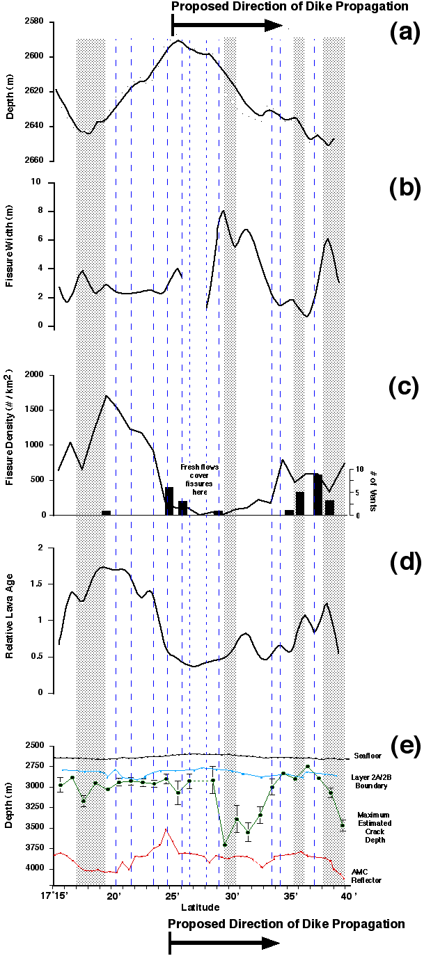
 Return From Whence You
Came!
Return From Whence You
Came!