 12/9/99 - NSF POWRE (Professional Opportunities for Women in Research & Education)
A sabbatical project is proposed that will allow the investigator to build on her earlier research in geographic information science (i.e., building marine data archive and distribution systems and bringing GIS analytical techniques to bear on marine geological/geophysical problems) while applying it to a completely new application area, thus facilitating a new line of basic research inquiry (i.e., a move from deepsea mid-ocean ridge and trench studies to coastal studies such as coral reef ecology, island coastal processes and habitat). In addition, professional growth will result in the area ofapplied research by way of new knowledge gained about marine sanctuaries, marine protected areas, and coastal resource management. Important new collaborations will be established to this end, both professionally and politically, that aid the investigator in her long-term career goal of overseeing and directing a major research center for coastal and marine environmental studies and geospatial data in the States and abroad. These collaborative ties will be made with the with the Sustainable Seas Expeditions (SSE), based in Santa Barbara, California, the Fagatele Bay National Marine Sanctuary (FBNMS) in American Samoa, and the broader NOAA Marine Sanctuary Program.
Three specific areas of enquiry, supportive of the major SSE components of exploration, development of ocean observatory and monitoring sites, and resource management issues will be addressed:
The investigator must be funded by the end of this review cycle in order to catch the momentum of current initiatives and be able to complete the proposed activities in time to be of most utility for planned phases of the SSE (which is already in year 2 of its 5 year program). The timing will be almost perfect, as the initial data sets to be included in the clearinghouse will be collected during the first exploratory mission to FBNMS in March of 2000.
1. POWRE Relevance Statement
1.1 Background - Summary of Current Research Specialties
The investigator's appointment to the Department of Geosciences at Oregon State University (OSU) placed her within the Geography program (to lead teaching, research, advising, and service in the extremely popular specialty of geographic information systems or GIS). It was also heavily predicated on her ability to foster cross- disciplinary research and teaching in the fields of geography, geology, and deep-water oceanography. This includes the ability to attract students with similar cross-disciplinary interests and to enter into research collaborations not only with the geologists in Geosciences, but with oceanographers in the neighboring College of Oceanic and Atmospheric Sciences (COAS) and the Hatfield Marine Science Center (HMSC) in Newport, Oregon.
The word research necessarily includes the pursuit and creation of knowledge, yet the investigator has practiced what geographers commonly designate as the scholarship of integration. She has sought to meld discoveries in geography with those from other specialties in order to create larger frameworks of meaning. This has led her to actively participate in two academic communities which, unfortunately, still appear to be fairly unaware of each other: physical geography/geographic information science (GISci) and marine geology/geophysics (deep-water). The investigator has published in leading journals for both communities, often bringing geographic information science techniques to bear on marine geological/geophysical problems while providing leadership within the GISci community for the notion that there exists a potential for GIS to benefit greatly from oceanography (e.g., Wright et al. [1995a], Wright and Goodchild [1997], Wright [1996, 1999a]). For instance, research issues endemic to oceanographic applications of GIS, such as the handling of spatial data structures that can vary their relative positions and values over time, geostatistical interpolation of data sparse in one dimensions as compared to the others, volumetric analysis, and the input and management of very large spatial databases will all advance the body of knowledge in GIS design and architecture, as well as the body of knowledge in the broader field of GISci. Her research to this end has focused on scientific information modeling to increase the efficiency of oceanographic spatial data management, and data conversion schemes for easier GIS input of oceanographic data (particularly marine bathymetry) (e.g., Wright [1994], Wright et al. [1998], Wright and Bartlett [in press]).
The investigator's research in marine geology has focused mainly on the fundamentals of fissure formation and development at the crest of mid-ocean ridges, having led or collaborated on several studies of fissuring on the East Pacific Rise (EPR; e.g., Wright et al. [1995a and b]; Wright et al. [submitted]). Fissures control the gross permeability of ocean crust, providing critical pathways for hydrothermal fluids and magma, and lending important clues to the cycling of volcanic and hydrothermal processes and the spatial and temporal stability of ridge segments. And yet, due to limitations in mapping technology that existed until the late 1980s, the critically important parameters of fissure abundance, spacing, length, width, and depth have rarely been reported anywhere on the seafloor, with the exception of the fast-spreading EPR. However, with the increasing availability of high resolution mapping tools, research agendas at various international workshops (e.g., Purdy and Fryer [1990], and Dziewonski and Lancelot [1995]) are now citing the determination of these parameters as a high priority for morphotectonic studies of the mid-ocean ridge that seek to more fully understand the nature of extensional failure of the ocean crust. The investigator has also worked on active tectonics problems at a convergent margin [Wright et al., in press].
1.2 Career Goals and Advancement
The investigator started her career as an assistant professor in 1995. Her record of research, teaching, advising, and service led to an early promotion to associate professor with indefinite tenure, effective September 15, 1999, and she is eligible for a sabbatical leave effective January 1, 2001. The investigator is therefore appreciative of the opportunity to compete for a POWRE award at this critical juncture in her career, which will provide a means by which she can take advantage of an opportunity that will contribute to a significantly new advance in her career path.
As competition for research dollars continues to increase exponentially for "blue-water" deep ocean research, the investigator would also like to explore problems of a more coastal nature, particularly with regard to coral reefs in shallow-water marine sanctuaries. The schism between geography/GIS and coastal studies is not nearly as wide as it is between deep-water research and there are many more opportunities for fruitful collaboration, as well as requests for proposals that explicitly call for an integration of the two fields. The societal implications of studies in these fields are also significantly richer. One major example is the study of coral reefs, which are recognized as being among the most diverse and valuable ecosystems on earth. Reef systems are storehouses of immense biological wealth and provide economic and ecosystem services to millions of people as shoreline protection, areas of natural beauty and recreation, and sources of food, pharmaceuticals, jobs, and revenues. Unfortunately, coral reefs are also recognized as being among the most threatened marine ecosystems on the planet, having been seriously degraded by human overexploitation of resources, destructive fishing practices, coastal development, and runoff from improper land-use practices. As the investigator pursues this new line of research inquiry (i.e., a move from deepsea mid- ocean ridges and trenches to coastal mapping, habitats, and resource management) the opportunities to integrate this research with education will also be much more readily apparent: coral reefs and coastal issues, combined with geographic information science, are "hot topics" which can be integrated into lectures and assignments in a wider variety of existing courses offered at OSU.
A primary career goal of the investigator in this regard is to position herself for a long term career goal of serving as director of a major research center for coastal and marine environmental studies and geospatial data (not unlike the NOAA Coastal Services Center on the east coast), to develop and implement an on-going research, educational and outreach program focused on geographic information science as applied to problems of the coast, continental shelf, and shallow reef environments. Specific goals for this "vision" include:
The investigator has made a small start toward this grand vision with her efforts developing a new geospatial clearinghouse for the Oregon coast [Wright, 1999b], in exploring with colleagues the issues surrounding marine sanctuaries and the possibility of proposing a new NOAA marine sanctuary off the Oregon coast, and in joining a recent working group on establishing the aforementioned major research center on the west coast. She views her planned sabbatical experience as an extremely important opportunity to further these efforts and to form vital new collaborations, both professionally and politically, that would not be possible without the support of the POWRE award. To summarize at this point, the professional development aspects of the preceding discussion are:
Explorations of new avenues of inquiry are not appropriate for a regular research or education proposal, nor are professional development activities such as networking, training and the building of research collaborations toward this end. Therefore, this request is being submitted as a POWRE proposal.
1.3 The Time is Now
The timing couldn't be more perfect to engage in these activities due to recent developments with the national marine sanctuaries and the Sustainable Seas Expeditions. The investigator must get involved within the next year in order to catch the momentum of current initiatives. Again, by way of background, the National Marine Sanctuary System was created in 1972 to protect ecological, historical, and aesthetic resources within vital areas of U.S. coasts [www.sanctuaries.nos.noaa.gov]. Currently there are 12 official sanctuaries protecting over 18,000 square miles of American coastal waters from American Samoa to Maine and the Florida Keys, including Pacific and Atlantic habitats for whales, sea lions, rays, and turtles, coral reefs, and kelp forests. These sanctuaries are largely unexplored below depths of ~30 m, and there has been no comprehensive documentation of the plants, animals, and submarine topography. A major initiative, administered by NOAA, has recently been launched to explore, document, and provide critical scientific data for these regions, with the goal of developing a strategy for the restoration and conservation of the nation's marine resources [Wilson, 1998]. One of the major catalysts behind this effort is the 5-year Sustainable Seas Expeditions (SSE; sustainableseas.noaa.gov), led by marine biologist and National Geographic Explorer-in- Residence Dr. Sylvia Earle and former National Marine Sanctuary program director Francesca Cava. SSE has been using new technologies, including their 1-personed submersible DeepWorker, to pioneer the first explorations of the sanctuaries. Its mission plan includes three phases the first of which is in progress now: to provide the first photo documentation of sanctuary plants, animals, and habitats at depths up to ~610 m. The second phase will expand on the characterization of habitats, focusing on larger animals such as whales, sharks, rays, and turtles, and compare habitat requirements among sanctuaries [Wilson, 1998]. Phase Three will include the all-important analysis and interpretation of the masses of data collected, as well as public outreach and education.
The investigator, due to heavy research and teaching commitments, was unable to answer the initial "call for collaboration" that went out to the marine research community in 1998 to join the expeditions of Phase One and participate in SSE submersible training. However, she had the pleasure of meeting Dr. Earle at a conference this summer and inquired as to the possibility of being included as an additional collaborator, given the needs and goals of the various sanctuaries. Due to recent developments, particularly at the Fagatele Bay Marine Sanctuary (see below), she has a wonderful opportunity to get involved in Phases Two and Three of the SSE, if she can complete the proposed activities for 2001. To wit, an email communication from John McDonough, SSE mission coordinator, that arrived during the final stages of preparation for this POWRE proposal:
Date: Mon, 06 Dec 1999 08:26:05 -0500
From: "John Mcdonough" <John.Mcdonough@noaa.gov>
Organization: NOAA/NOS/Special Projects
To: "Dawn Deepsea" <dawn>, Nancy Daschbach <Nancy.Daschbach@noaa.gov>
CC: Dan Basta <Dan.Basta@noaa.gov>
Our meetings with Sylvia and the National Geographic folks last week went very well, resulting in some refinements to proposed SSE operations in order to better enable us to focus on the goals and objectives of the project. To summarize briefly, one of the primary objectives of SSE has been to enhance site characterization efforts at each sanctuary. Based on our experiences this past year, it is now being proposed to focus exploration and research efforts on characterizing two discrete sites within each sanctuary for comparative assessment. One site would be of special biologic significance (such as a no take zone within a sanctuary or an area exhibiting a high degree of biologic diversity), and the other a site that is significantly less diverse. To accomplish a thorough, ongoing assessment, Sylvia and the Geographic are prepared to invest in an instrument package that could be installed on the bottom at each site to collect standard water quality measurements (i.e., temperature, salinity, conductivity, transmissivity, O2, etc.). These instruments would remain at these sites for the foreseeable future, allowing data to be collected in between visits. In addition, SSE research efforts at these sites, either using the DeepWorker or an ROV [remotely- operated vehicle] or AUV [autonomous underwater vehicle], would focus on specific tasks such as collecting videotape, still photography, CTD data, sediment samples, etc. to add to the characterization of the sites.
In terms of the proposed mission to American Samoa [March 2000], Sylvia has elected not to visit the sanctuary..., allowing more time to further develop the ideas outlined above. This does not mean that there will be no work done at the sanctuary, however. Based on the new focussed approach, the NOS Special Projects Office and the Marine Sanctuaries Division are prepared to continue to work with the sanctuary to identify target locations within (or outside) the sanctuary for a mission in 2001. In essence, this work is complementary to the work you have outlined in objective 1 of your [pre-]proposal.
2.0 Why Santa Barbara and Why the Fagatele Bay National Marine Sanctuary?
The investigator proposes to complete the majority of the project in Santa Barbara where the Sustainable Seas main office is located and where she also has an existing network of marine science and geographic information science colleagues at UC-Santa Barbara. She will also be housed on the UC-Santa Barbara campus, due to lack of office space at SSE (see Facilities and Supplementary Documents sections of proposal).
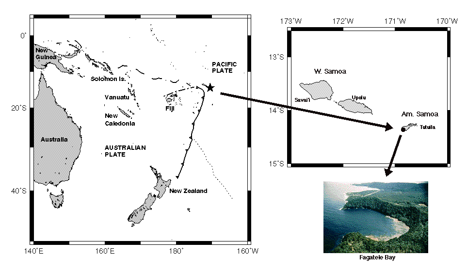
The Fagatele Bay National Marine Sanctuary (FBNMS; Figure 1) has been chosen as focus because it is one of the last sanctuaries that will be visited by the SSE. Unlike the larger sanctuaries off the coast of the continental U.S. and Hawaii, the science plans for FBNMS are still being developed and refined, due in part to the probability that it will not be visited by the DeepWorker submersible in the near future. In addition, because the site is so remote, there is also a much greater need here for large-scale (high-resolution), fully processed, interpreted and accessible baseline data to characterize the sanctuary, as well as new partnerships and input from collaborating researchers. Therefore, of all the sanctuaries targeted by SSE the investigator stands to make the greatest contribution at Fagatele Bay, especially since she is currently involved in a seafloor mapping project near that region [Wright et al., in press] (see also dusk.geo.orst.edu/tonga) and has already traveled throughout American Samoa (as well as Fiji and Tahiti). Additional proposed activities can be completed by a 1-2 week stay at the FBNMS.
|
Figure 1:
Regional location maps of the
study area in the Southwest Pacific. Map on left shows
major submarine tectonic features in the region: Tonga
Trench (solid line w/barbs on overriding plate), Fiji
Fracture Zone and Vitiaz Trench Lineament (dashed line),
and Louisville Ridge (dotted line).
Click on the image for an expanded view
|
Fagatele Bay is an ancient flooded volcano, with a thriving coral and calcareous algal reef community that is rapidly recovering from an infestation of crown-of-thorns starfish that devastated the corals in the late 1970s [www.fbnms.nos.noaa.gov]. Although much of the coral cover has been destroyed, fish populations still thrive, particularly surgeonfish, damselfish and angelfish [Akins, 1999]. In addition, the steep slopes surrounding the bay contain some of our nation's rare paleo-tropical rainforest [www.fbnms.nos.noaa.gov/].
BACK TO TOP3.0 Proposed Activities
The following proposed activities address crosscutting issues of information infrastructure that should support three major components of SSE: exploration, development of ocean observatory and monitoring sites, resource management issues [Wilson, 1998]. Collaboration with SSE is proposed with regard to three objectives:
3.1 Objective (1): Data Integration and Management
Developing and carrying out sustainability and coastal management programs that are ecosystem-sensitive and have public support requires that SSE scientists and managers have efficient access to high-quality marine and coastal data. This is particularly crucial for SSE Phases One (understanding species composition and abundance, development of sanctuary program monitoring protocols) and Two (implementation of monitoring protocols and visitation of no-take zones to check on system health or change). Objective (1) is concerned primarily with the integration of existing data into a GIS "clearinghouse" of both data and FGDC-compliant metadata (i.e., data about data) for the FBNMS. These data can then be integrated with subsequent SSE survey data. The clearinghouse will facilitate the continued distribution and synthesis of information on the sanctuary. It will help to integrate a wide range of data sources and allow scientists and resource managers to analyze ecosystem characteristics at large spatial and temporal scales (into the future, or retrospectively with older data sets). It is anticipated that the clearinghouse will also be used as a focus for communication and cooperation among agencies and residents of American Samoa, as well as the other sanctuaries, thereby leading to a common ground for decision-making. In a nutshell, the expected outcomes are: (1) less confusion about important data sets; (2) distribution of the data in such a way as to enhance the interpretation or conduct of SSE research; (3) increased contacts and opportunities for collaboration; (4) increased scientific understanding, particularly in key time series studies for habitat sustainability and coastal development policy-making.
Framework data sets will include (white = existing data, yellow = future possibilities):
It is anticipated that observations gathered with an ROV or DeepWorker will use census protocols from the Reef Environmental Education Foundation (www.reef.org) to establish baseline data for deep habitats in the sanctuary. The data will be used to characterize deep water habitats and assess long-term trends of fish assemblages, allowing scientists and managers to identify, characterize, and rectify human-caused disturbance, should it occur [Akins, 1999].
Once a critical mass of data and information are available for the FBNMS, steps must be taken to ensure that they are never scattered in various formats and among several agencies, research institutes or universities. Tracking down desired data and metadata will be a daunting task for managers and scientists without a structured clearinghouse. For the general public the task will be even more difficult. Many data sets may be restricted to individual projects and then shelved, eliminating the potential for usefulness in a myriad of additional planning, management, and scientific projects. Managers, scientists, and the public have all expressed confusion over the complexity of identifying data at suitable scales, formats, and quality for designated management areas. Clearly then, there is a need to maintain an established clearinghouse, as well as a unified, policy-driven data framework before the quantity of data becomes somewhat overwhelming. Steps will include: (1) identify data sources and contact information; (2) establish an order of prioritization for data entry based both on availability and quality of the data; (3) integrate digital data into the GIS (ArcView and ArcInfo) using simple format filters and data input programs that have already been developed by Wright et al. [1997]; (4) compile metadata for all data layers; (5) upload to a web- based clearinghouse where users can view and query data and metadata online. All metadata will be created in compliance with the Federal Geographic Data Committee (FGDC) national standard. Protocols and maintenance procedures for data contributed to the clearinghouse will also be documented. A database framework document for future acquisitions will be created.
3.2 Objective (2): Analytical Procedures for Coral Reef Ecology
As data compilation for FBNMS grows it will be important to put it into the context of research questions that will guide management and protection protocols. For example [Treml, 1999].
This objective would explore a GIS approach to conducting a landscape ecology analysis for approaching some of these questions, which would have useful implications for the planning of future ROV, AUV or DeepWorker dives in SSE Phases One and Two and final analysis and interpretation in Phase Three. Further hypotheses may even be developed by local grade school or high school students as part of an educational outreach on the island. Bridgewater [1993] notes that combining a landscape approach with a GIS is desirable because it allows study of the structure, function and change within coral reef systems while managing the many spatial and temporal scales As a pilot study, a few physical factors important to coral reef development, along with several community descriptors (all subject to available data, primarily collected in March 2000) could be analyzed in the GIS via query, spatial correlation tests, and buffer analysis. Treml [1999] was successful with this approach in analyzing coral reef community ecology on St. John, U.S. Virgin Islands using factors such as current regime, substrate characteristics, coastal topography, bay geometry, watershed size, sedimentation, tropical storm impact, bathymetry, biodiversity, evenness biota distribution, and algae cover.
3.3 Objective (3): Information Space Modeling
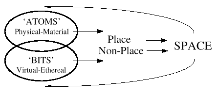
Similar to many scientific and applied research fields, geography has moved from a data-poor to a data-rich and computation-rich environment [Miller and Han, 1999]. The scope, coverage and volume of digital geographic data sets are growing rapidly due to new high-resolution satellite systems, initiatives such as the National Spatial Data Infrastructure [Buttenfield, 1997], and data collection that is expanding from traditional vector and raster models to including georeferenced multimedia data [Miller and Han, 1999]. A paradox of the FBNMS is that it is currently and will probably continue to be for a few years, a relatively data-poor environment, owing primarily to its isolation. The investigator conducted a fairly comprehensive web search for geospatial data from American Samoa and was able to find only water level stations and geodetic control points from 1971. An interesting research question to explore as a second objective for the project is the feasibility of "information space modeling" as a means for faster, more efficient access of data and information for the sanctuary, to augment what will be collected in the field. For example, useful information could include ecological interpretations and protection protocols that have been established at similar sites in the Pacific that are trying to protect coral reefs. Information space modeling has arisen from the realization of a fundamental shift now taking place from a world that is based on the physical and material to one that is based on information (Figure 2). As such, the role of physical distance is changing as it is complemented by near instantaneous transactions in "cyberspace" that dramatically distort the effect of distance, thereby changing the traditional bonds which have led to the current geographical organization of regions [Cairncross, 1997]. Indeed, Batty and Harvey [in press] maintain that there is an urgent need for a major initiative in the collection of network data and its subsequent analysis with respect to the search for new "information spaces", some of which may useful for augmenting data-poor environments.
Construction of an information space model would include
mapping out the locations of telecommunication networks,
listing the pertinent contents of digital libraries as well
as the policies and costs related to their operations, in
essence constructing an "information delivery network" map
for data being delivered to the National Marine Sanctuary
System or other archives that could be useful to the FBNMS.
Previous studies that could inform this work include the
information delivery network map of Murr et al.
[1995], of the Encyclopedia of World Problems and Human
Potentials [Union of International Associations,
1991], the Internet diffusion maps of Matrix in the
World [1995], and information space models of
Schroeder [1997]. 3.3 Additional Possibilities for a Baseline
Mapping Objective A research cruise in March 1999 led by Dr. Stan Hart of
the Woods Hole Oceanographic Institution discovered and
mapped a new, active submarine volcano east of Ta'u,
American Samoa. His team will return in March 2000 to drop
hydrophones near the volcano from the R/V Polar Star. Dr.
Hart and I will be collaborating on a NSF proposal, to be
submitted February 2000, that will return to the volcano to
resurvey the summit crater and search for any associated
hydrothermal vents and biota with the Autonomous Benthic
Explorer (ABE), the Jason ROV, and the DSL-120 deep-towed
sidescan sonar. A nighttime program for this cruise would
be a complete survey of the FBNMS with ABE, as well as the
submerged portions of the National Park of America Samoa.
An AUV such as ABE is extremely desirable as a survey tool
for such a small region (0.25 sq. mi.). Survey duration
would be 1-2 days. In general AUVs are cheaper to
operate than ROVs ($5K to ship just a 20-foot van with
vehicle and supplies halfway around the world), have
enormous flexibility (fully autonomous or acoustically
controlled, 6000 m depth range, CTD, beam and backscatter
mapping, photography, etc.), and require only a small team
to operate. If this NSF proposal is funded, the survey would
likely occur during the time of the investigators proposed
POWRE activities and could be done in conjunction with
setting up the GIS data and web serving machines at the
FBNMS. Such a survey will not only greatly extend the SCUBA
transect capabilities for examining and validating physical
habitat maps of the bay but should also provide a better
means of evaluating characteristics of the habitat, such as
seafloor roughness, sediment and/or algal cover, reef size,
vertical relief, etc. so that it may be determined what
attracts and retains the destructive crown-of-thorn
starfish, as well as fishes, sea turtles, and marine
mammals. It should be possible to determine species
abundance for many different fish and invertebrates in
various sectors of the bay (to be determined by the initial
survey in March 2000). In addition, bathymetric maps and
habitat associations of these species will be used to
expand the species abundances over the bay in order to get
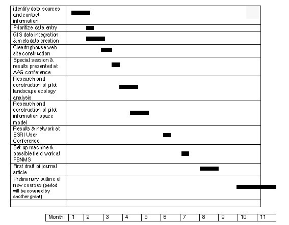
a total abundance for each species. 3.4 Milestone Chart for Completion of
Objectives
4.0 Results of Prior NSF Support
"CAREER: Crustal Cracking Along Multi-Segment Portions of the Juan de Fuca Ridge and its Relation to Ridge Segmentation"
NSF Grant Number: OCE- 9521039
Principal Investigator: D.J. Wright
Total Amount: $79,958
Duration: September 1, 1995 - August 31, 1999
This project is supported under the NSF Faculty Early Career Development (CAREER) Program. It provides support over four years for a new Oregon State University (OSU) faculty member, Dr. Dawn Wright, to develop new, interdisciplinary courses in the geosciences, to promote scientific careers to undergraduate and high school students and graduate students (particularly students of color), and to carry out a two-pronged research program in different aspects of marine geophysics. The first part of the proposed research focused on a study of the geophysical development of the Tonga forearc, a region formed in response to ocean crust subduction and characterized by uplift of volcanoes and deep ocean crustal material west of the Tonga trench in the western Pacific Ocean. The fieldwork (Boomerang Leg 8 aboard the R/V Melville in May- June, 1996) was carried out successfully in collaboration with Dr. Sherman Bloomer, Chair of the OSU Department of Geosciences (as part of grant OCE-9521023, "Dynamics of Extensional Convergent Margins and the Origin of Supra- Subduction Zone Ophiolites: Hypothesis Testing in the Tonga Forearc; S.H. Bloomer and D.J. Wright, $429,205).
The second focus was to be an investigation of crustal faulting and fissuring along the Juan de Fuca Ridge, a highly active ocean-spreading center located offshore western North America from northern California to Canada. Examination of the existing side-scan sonar data sets for this project revealed many artifacts and navigational errors, too numerous to undertake the study as planned. The data have also been since superceded by many surveys of portions of the ridge with newer, higher-quality AMS 60 sidescan data, which are still under the proprietary control of researchers at NOAA-PMEL in Newport, Oregon. As an approved substitute, Wright participated in a research cruise to the southern East Pacific Rise at 17-18° S and used DSL 120 sidescan sonar plus Argo II video data to attack the same fissure problem on the East Pacific Rise. This included the integration of the side-scan sonar and photographic data along the spreading axis to define the distribution and characteristic of cracks developed in response to the stresses involved in ocean crust formation. Understanding the distribution, length and shape of these cracks is improving our understanding of the mechanisms involved in sea floor spreading and expands on Dr. Wright's previous crack formation work
on the northern East Pacific Rise at 9-10 N.
Aspects of both research programs have been integrated into new courses developed for graduate and undergraduate education at Oregon State University. Publications supported by this grant are included in References Cited below.
"A Scientific Information Management Schema for the Endeavour Portion of the Juan de Fuca Ridge Observatory"
NSF Grant Number: OCE- 9633609
Principal Investigator: D.J. Wright (OSU) and R.E. McDuff (U. Washington)
Total Amount: $180,279
Duration: May 15, 1997 - April 30, 1999
Funding was provided to integrate accurately-located, high-resolution topographic, photographic, seismic, chemical, geological, biological and acoustic data from the Endeavour Segment of the Juan de Fuca Ridge into a marine geographic information system (GIS) for support of the RIDGE Observatory Experiment (ROBE). In order to maximize the scientific return from these measurements, the system was implemented using an existing GIS architecture (ArcView). The GIS provides comprehensive data management, documentation, an interactive user interface, and data quality control for the multidisciplinary data from the Endeavour Segment. Comprehensive data management was achieved by properly integrating all existing data into the GIS and thoroughly documenting the effort. The project is an essential component of the RIDGE program for several reasons:
Final results are being continually updated by R. McDuff and a UW student at www2.ocean.washington.edu/gis. This site is the heart of what the award was granted for. It allows the RIDGE community to access Endeavour data in various formats (text, GMT-style grids, and ArcInfo GIS coverages and grids which are also readable by the ArcView GIS). It also makes some public domain software tools available to aid in viewing and converting data. The site will eventually link to other sites maintained by data contributors.
The project provided part of a Master's thesis project for Hamilton Smillie in which he learned about the National Spatial Data Infrastructure and the Federal Geographic Data Committee content standard for geospatial metadata that was an integral part of the project. He researched the various tools used for the creation and management of metadata in relation to GIS and created a set of metadata documents for the Endeavour GIS. These skills led to a position as a metadata specialist/GIS analyst immediately upon his graduation, as the NOAA Coastal Services Center in Charleston, SC. Publications supported by this grant are included in References Cited below.
REFERENCES CITED
Results from Prior Support: OCE-9521039, References Cited
Bloomer, S. and D. Wright, Summary of Site Survey Cruise Results, Boomerang Leg 08. In Support of Proposal 451, Ocean Drilling in the Tonga Forearc: Subduction Geodynamics, Arc Evolution, and Deformation Processes at a Non-Accretionary Convergent Margin. Ocean Drilling Program Site Survey Cruise Report, Department of Geosciences, Oregon State University, Corvallis, OR, 87 pp., 1996.
Bloomer, S.H, D.J. Wright, and Boomerang Leg 8 Shipboard Scientific Party, Geology of the Tonga Forearc: A supra-subduction zone ophiolite, Eos Trans. AGU, 77(46), F325, 1996.
Clift, P.D., C.J. MacLeod, D.J. Tappin, S.H. Bloomer, D.J. Wright, and Boomerang Leg 8 Shipboard Scientific Party, Forearc sedimentation, subduction erosion and the effect of seamount collisions in the Tonga Arc, Eos Trans. AGU, 77(46), F326, 1996.
Clift, P.D., C.J. MacLeod, D.R. Tappin, D.J. Wright, and S.H. Bloomer, Tectonic controls on sedimentation in the Tonga Trench and Forearc, SW Pacific, Geol Soc. Am. Bull., in press, 1998.
Falloon, T.J., S.H. Bloomer, and A.J. Crawford, Boninites recovered from the Tonga forearc, Eos Trans. AGU, 78(46), F815, 1997.
Kelman, M., S. Bloomer, and T. Falloon, Hydrothermal alteration of a forearc ophiolite, Tonga, Southwest, Pacific, Eos Trans. AGU, 78(46), F807, 1997.
Sato, H., T. Ishii, S.H. Bloomer, D.J. Wright, and Boomerang Leg 8 Shipboard Scientific Party, Serpentinites from the Izu-Bonin-Mariana and Tonga Forearcs: Similarities and differences, Eos Trans. AGU, 77(46), F325, 1996.
Wright, D.J., Formation and development of fissures at the East Pacific Rise: Implications for faulting and magmatism at mid-ocean ridges, in Buck, W.R., Delaney, P., and Karson, J.A. (Eds.), Faulting and Magmatism at Mid-Ocean Ridges, AGU Monograph, Washington, D.C: American Geophysical Union, 137-151, 1998.
Wright, D.J., R. Wood, and B. Sylvander, ArcGMT: A suite of tools for conversion between Arc/INFO and Generic Mapping Tools (GMT), Computers and Geosciences, 24(8): 737-744.
Wright, D.J., S.H. Bloomer, and Boomerang Leg 8 Shipboard Scientific Party, New Sea Beam 2000 bathymetry and sidescan data on the Tonga Forearc and Trench: Results from Boomerang Leg 8, an ODP site survey, Eos Trans. AGU, 77(46), F326, 1996.
Wright, D.J., Semantic modelling for oceanographic data in Craglia, M.A and Onsrud, H. (Eds.), Geographic Information Research: Trans-Atlantic Perspectives, London: Taylor and Francis, 405-414, 1999.
Wright, D.J., S.H. Bloomer, B. Taylor., A.M. Goodliffe, and C.J. MacLeod, Bathymetry of the Tonga Trench and Forearc, Marine Geophysical Researches, in press, 1999.
Wright, D.J., R.M. Haymon, S.M. White, and K.C. Macdonald, Crustal fissuring on the crest of the southern East Pacific Rise, 17° 15'-40'S and 18° 23'-30'S: Further insights into volcanic-hydrothermal-tectonic cycles, J. Geophys. Res., submitted, 1999.
Results from Prior Support:
OCE-9633609, References CitedWright, D.J. and McDuff, R.E. , A geographic information system for the Endeavour Segment, RIDGE Events, 9(1):11-15, 1998.
http://www2.ocean.washington.edu/gis
Current Submission, References Cited
Akins, L., Deep-water fish assemblage characterization of the National Marine Sanctuaries, Sustainable Seas Mission Abstract, http://www.sanctuaries. nos.noaa.gov/sse/investigations/projects/multiple/akins.htm l, 1999.
Batty, M., and H. Miller, Representing and visualizing physical, virtual and hybrid information spaces, in Information, Places, and Cyberspace: Issues in Accessibility, edited by D. Janelle, and D. Hodge,14 pp., Springer-Verlag, Berlin, in press, 2000.
Bridgewater P.B., Landscape ecology, geographic information systems and nature conservation, in R. Haines- Young, D.R. Green and S. Cousins (eds.), Landscape Ecology and Geographic Information Systems, London, Taylor and Francis, pp. 23-36, 1993.
Buttenfield, B.P., Delivering geospatial data: The future of the spatial information infrastructure, Geo Info Systems, 7, 18, 20-21, 1997.
Dziewonski, A., and Y. Lancelot, Multidisciplinary Observatories on the Deep Seafloor, pp. 229, INSU/CNRS/IFREMER/USSAC/ODP, Marseilles, France, 1995.
Killpack, D., Protected areas GIS: Bringing GIS to the desktops of the National Estuarine Research Reserves and Marine Sanctuaries, in Proceedings of the 19th Annual ESRI User Conference, Paper 198, http://www.esri.com/library/userconf/proc99/ proceed/papers/pap198/p198.htm, Environmental Systems Research Institute, San Diego, California, 1999.
Miller, H., and J. Han, Discovering geographic knowledge in data-rich environments, in Specialist Meeting Report, Project Varenius, 70 pp., National Center for Geographic Information and Analysis, Kirkland, Washington, 1999.
Negroponte, N., Being Digital, A. A. Knopf, New York, 1995.
Purdy, G.M., and G.J. Fryer, Proceedings of a Workshop on the Physical Properties of Volcanic Seafloor, pp. 279, Woods Hole Oceanographic Institution, Woods Hole, MA, 1990.
Treml, E., Fringing reef framework development and maintenance of coral assemblages along St. John's south shore: A geographic information system (GIS) analysis, Master's thesis, University of Charleston, Charleston, South Carolina, 1999.
Wilson, A.D., America's fragile sea sanctuaries-- Exploring and documenting, Sea Technol., 39, 29-33, 1998.
Wright, D.J., From Pattern to Process on the Deep Ocean Floor: A Geographic Information System Approach, Ph.D. thesis, University of California, Santa Barbara, 1994.
Wright, D.J., Rumblings on the ocean floor: GIS supports deep-sea research, Geo Info Systems, 6 (1), 22-29, 1996.
Wright, D.J., Getting to the bottom of it: Tools, techniques, and discoveries of deep ocean geography, Prof. Geog., 51 (3), 426-439, 1999a.
Wright, D.J., A geospatial clearinghouse for the Oregon coast: Implications for improved hazard assessment, in Abstracts of the Association of American Geographers 95th Annual Meeting, pp. CD-ROM, Session 313, Association of American Geographers, Honolulu, Hawaii, 1999b.
Wright, D.J., and M.F. Goodchild, Data from the deep: Implications for the GIS community, Int. J. Geog. Inf. Sys., 11, 523-528, 1997.
Wright, D.J., and D.J. Bartlett (eds.), Marine and Coastal Geographical Information Systems, 383 pp., Taylor & Francis, London, in press, 1999.
Wright, D.J., R.M. Haymon, and D.J. Fornari, Crustal fissuring and its relationship to magmatic and hydrothermal processes on the East Pacific Rise crest (9°12'-54'N), J. Geophys. Res., 100 (B4), 6097-6120, 1995a.
Wright, D.J., R.M. Haymon, and K.C. Macdonald, Breaking new ground: Estimates of crack depth along the axial zone of the East Pacific Rise (9°12'-54'N), Earth Planet. Sci. Lett., 134, 441-457, 1995b.
Wright, D.J., C.G. Fox, and A.M. Bobbitt, A scientific information model for deepsea mapping and sampling, Mar. Geod., 20 (4), 367-379, 1997.
Wright, D.J., R. Wood, and B. Sylvander, ArcGMT: A suite of tools for conversion between Arc/INFO and Generic Mapping Tools (GMT), Comp. Geosci., 24, 737- 744, 1998.
Wright, D.J., S.H. Bloomer, C.J. MacLeod, B. Taylor, and A.M. Goodliffe, Bathymetry of the Tonga Trench and forearc: A map series, Mar. Geophys. Res., in press, 1999.
Wright, D.J., R.M. Haymon, S.M. White, and K.C. Macdonald, Crustal fissuring on the crest of the southern East Pacific Rise, 17° 15'-40'S and 18° 23'-30'S: Further insights into volcanic-hydrothermal-tectonic cycles, J. Geophys. Res., submitted, 1999.
Current Submission, Working Bibliography
Akins, L., Deep-water fish assemblage characterization of the National Marine Sanctuaries, Sustainable Seas Mission Abstract, http://www.sanctuaries. nos.noaa.gov/sse/investigations/projects/multiple/akins.htm l, 1999.
Allison, G.W., J. Lubchenco, and M.H. Carr, Marine reserves are necessary but not sufficient for marine conservation, Ecol. Appl., 8, S79-S92, 1998.
Aston, J., Experiences of coastal management in the Pacific islands, Ocean Coast. Mgmt., 42, 483- 501, 1999.
Batty, M., and H. Miller, Representing and visualizing physical, virtual and hybrid information spaces, in Information, Places, and Cyberspace: Issues in Accessibility, edited by D. Janelle, and D. Hodge,14 pp., Springer-Verlag, Berlin, in press, 2000.
Bloomer, S. and D. Wright, Summary of Site Survey Cruise Results, Boomerang Leg 08. In Support of Proposal 451, Ocean Drilling in the Tonga Forearc: Subduction Geodynamics, Arc Evolution, and Deformation Processes at a Non-Accretionary Convergent Margin. Ocean Drilling Program Site Survey Cruise Report, Department of Geosciences, Oregon State University, Corvallis, OR, 87 pp., 1996.
Bohnsack, J.A., Marine reserves: They enhance fisheries, reduce conflicts, and protect resources, Oceanus, 36, 63-71, 1993.
Bridgewater P.B., Landscape ecology, geographic information systems and nature conservation, in R. Haines- Young, D.R. Green and S. Cousins (eds.), Landscape Ecology and Geographic Information Systems, London, Taylor and Francis, pp. 23-36, 1993.
Bryant, D., L. Burke, J.W. McManus, and M. Spalding, Reefs at Risk: A Map-Based Indicator of Potential Threats to the World's Coral Reefs, 56 pp., World Resources Institute, Washington, D. C., 1998.
Bunt, J.S., How can fragile marine ecosystems best be conserved?, in Use and Misuse of the Seafloor, edited by K.J. Hsü, and J. Thiede, pp. 229-242, John Wiley & Sons Ltd., New York, 1992.
Buttenfield, B.P., Delivering geospatial data: The future of the spatial information infrastructure, Geo Info Systems, 7, 18, 20-21, 1997.
Cairncross, F., The Death of Distance, Harvard Business Press, Cambridge, Massachusetts, 1997.
Earle, S.A., and W. Henry, Wild Ocean: America's Parks Under the Sea, 223 pp., National Geographic Society, Washington, D. C., 1999.
English, S., C. Wilkinson, and V. Baker, Survey Manual for Tropical Marine Resources, 390 pp., Australian Institute of Marine Science, Townsville, Australia, 1997.
Flewelling, D.M., and M.J. Egenhofer, Using digital spatial archives effectively, Int. J. Geogr. Info. Sci., 13, 1-8, 1999.
Glantz, M.H., Floods, fires, and famine: Is El Niño to blame?, Oceanus, 27, 14-19, 1984.
Hale, L.Z., and S.B. Olsen, Coral reef management in Thailand, Oceanus, 36, 27-34, 1993.
Killpack, D., Protected areas GIS: Bringing GIS to the desktops of the National Estuarine Research Reserves and Marine Sanctuaries, in Proceedings of the 19th Annual ESRI User Conference, Paper 198, http://www.esri.com/library/userconf/proc99/ proceed/papers/pap198/p198.htm, Environmental Systems Research Institute, San Diego, California, 1999.
Limp, W.F., Mapping hits warp speed on the World Wide Web!, GEOWorld, 12, 32-34, 36, 40, 42, 1999.
Masser, I., All shapes and sizes: The first generation of national spatial data infrastructures, Int. J. Geogr. Info. Sci., 13, 67-84, 1999.
Mather, P.M., Computer Processing of Remotely-Sensed Images, 292 pp., John Wiley and Sons, Chichester, 1999.
Miller, H., and J. Han, Discovering geographic knowledge in data-rich environments, in Specialist Meeting Report, Project Varenius, 70 pp., National Center for Geographic Information and Analysis, Kirkland, Washington, 1999.
Milliman, J.D., Management of the coastal zone: Impact of onshore activities on the coastal environment, in Use and Misuse of the Seafloor, edited by K.J. Hsü, and J. Thiede, pp. 213-227, John Wiley & Sons Ltd., New York, 1992.
Morrison, R.J., and M.R. Naqasima, Fiji's great Astrolabe Lagoon: Baseline study and management issues for a pristine marine environment, Ocean Coast. Mgmt., 42, 617-636, 1999.
National Marine Sanctuary System, http://www.sanctuaries.nos.noaa.gov.
Negroponte, N., Being Digital, A. A. Knopf, New York, 1995.
O'Neill, B., Alternative support for protected areas in an age of deficits, Oceanus, 36, 49-52, 1993.
Sobel, J., Conserving biological diversity through marine protected areas: A global challenge, Oceanus, 36, 19-26, 1993.
Solomon, S.M., and D.L. Forbes, Coastal hazards and associated management issues on South Pacific islands, Ocean Coast. Mgmt., 42, 523-554, 1999.
South, G.R., and J. Veitayaki, Capacity building in the South Pacific and the role of the marine studies programme at the University of the South Pacific, Ocean Coast. Mgmt., 41, 103-113, 1998.
Sustainable Seas Expeditions, http://sustainableseas.noaa.gov.
Treml, E., The effects of disturbance on coral reef community strucuture: The perfect job for GIS, in Proceedings of the 18th Annual ESRI User Conference, pp. CDROM and http://www.esri.com/library/userconf/proc98/PROCEED.HTM, Environmental Systems Research Institute, San Diego, California, 1998.
Treml, E., Fringing reef framework development and maintenance of coral assemblages along St. John's south shore: A geographic information system (GIS) analysis, Master's thesis, University of Charleston, Charleston, South Carolina, 1999.
Tsaymenyi, T., The institutional framework for regional cooperation in ocean and coastal management in the South Pacific, Ocean Coast. Mgmt., 42, 465-481, 1999.
Wilson, A.D., America's fragile sea sanctuaries-- Exploring and documenting, Sea Technol., 39, 29-33, 1998.
Wright, D.J., From Pattern to Process on the Deep Ocean Floor: A Geographic Information System Approach, Ph.D. thesis, University of California, Santa Barbara, 1994.
Wright, D.J., Rumblings on the ocean floor: GIS supports deep-sea research, Geo Info Systems, 6 (1), 22-29, 1996.
Wright, D.J., Getting to the bottom of it: Tools, techniques, and discoveries of deep ocean geography, Prof. Geog., 51 (3), 426-439, 1999a.
Wright, D.J., A geospatial clearinghouse for the Oregon coast: Implications for improved hazard assessment, in Abstracts of the Association of American Geographers 95th Annual Meeting, pp. CD-ROM, Session 313, Association of American Geographers, Honolulu, Hawaii, 1999b.
Wright, D.J. and McDuff, R.E. , A geographic information system for the Endeavour Segment, RIDGE Events, 9(1):11-15, 1998.
Wright, D.J., and M.F. Goodchild, Data from the deep: Implications for the GIS community, Int. J. Geog. Inf. Sys., 11, 523-528, 1997.
Wright, D.J., and D.J. Bartlett (eds.), Marine and Coastal Geographical Information Systems, 383 pp., Taylor & Francis, London, in press, 1999.
Wright, D.J., C.G. Fox, and A.M. Bobbitt, A scientific information model for deepsea mapping and sampling, Mar. Geod., 20 (4), 367-379, 1997.
Wright, D.J., S.H. Bloomer, C.J. MacLeod, B. Taylor, and A.M. Goodliffe, Bathymetry of the Tonga Trench and forearc: A map series, Mar. Geophys. Res., in press, 1999.
Zann, L.P., A new (old) approach to inshore resources management in Samoa, Ocean Coast. Mgmt., 42, 569-590, 1999.
BACK TO TOP
| NSF POWRE Proposal Submitted by Dawn J. Wright | ||||
| Titled: New Collaborative Research with the Sustainable Seas Expeditions… | ||||
| Proposed Project Dates: 12/16/2000 - 9/15/2001 | ||||
| Fiscal | Fiscal | |||
| Year 1 | Year 2 | OSU | ||
| 00/01 | 01/02 | Cumulative | C/S | |
| A. SENIOR PERSONNEL | ||||
| Dawn J. Wright, P.I. 6 mos., .40 FTE/WSp | 14,914 | 14,914 | 22,370 | |
| Dawn J. Wright, P.I. 2.5 mos., 1.0 FTE/Sum | 16,157 | 16,157 | 0 | |
| Total Senior Personnel | 14,914 | 16,157 | 31,071 | 22,370 |
| Total Salary & Wages | 14,914 | 16,157 | 31,071 | |
| C. FRINGE BENEFITS | 4,922 | 5,493 | 10,415 | 7,382 |
| Sr. Per. .33, .34 | ||||
| Total Salary & Benefits | 19,836 | 21,650 | 41,486 | 29,752 |
| E. TRAVEL | ||||
| 1. Domestic - relocation costs to/from Corvallis | 1,000 | 1,000 | 2,000 | 0 |
| 2. Domestic - attend AAG conf., New York City | 1,285 | 0 | 1,285 | 0 |
| RT airfare, Per diem 5 days @ $110/day, | ||||
| 5 day car rental | ||||
| 3. Domestic - attend ESRI conf., San Diego | 0 | 628 | 628 | 0 |
| Per diem 5 days @ 110/day, personal auto | ||||
| 4. Foreign - Am. Samoa field work | 0 | 2,850 | 2,850 | 0 |
| RT airfare LAX-Samoa-LAX, Per diem 5 days | ||||
| @ $110/day | ||||
| G. OTHER DIRECT COSTS | ||||
| 1. Materials and Supplies* (inc. purchase of PC) | 4,500 | 500 | 5,000 | |
| 2. Publication Costs | 0 | 500 | 500 | |
| Total Other Direct Costs | 4,500 | 1,000 | 5,500 | 0 |
| H. TOTAL DIRECT COSTS | 26,621 | 27,128 | 53,749 | 29,752 |
| I. INDIRECT COSTS RATES | 6,921 | 7,053 | 13,974 | 7,736 |
| 00/01 Yr. 1 26% Total Direct Costs | ||||
| 01/02 Yr. 2 26% Total Direct Costs | ||||
| Off - Campus Rate | ||||
| J. TOTAL DIRECT+INDIRECT | 33,542 | 34,181 | $67,723 | 37,488 |
| L. AMOUNT OF THIS REQUEST | 33,542 | 34,181 | 67,723 | 37,488 |
| Note: Cost Share (C/S) is represented by a 60% sabbatical salary to be paid by OSU |
NSF POWRE (December 9, 1999)
Ford Foundation (January 7, 2000)
National Geographic Research & Exploration (Preproposal sent April 25, 2000, invited to submit full proposal June 12th)
NOAA CSC (June 1, 2000)
Sustainable Seas
Sylvia Earle bio
National Geographic Sanctuary Site
National Park of American Samoa
Bishop Museum Coral Reef Expedition (Palau inc. explanation of rebreather technology)
Protecting Coral Reefs
Island Resources Foundation
Pew Oceans Commission
SSE Background
Marine
Sanctuaries (ESRI)
SSE Channel Islands Internet Camp
SSE Call
MBNMS Research Plan
MBNMS Project
Fagatele Bay
NMS
Asia-Pacific Mapping/RS/GIS portal
A Virtual Dive with ABE
SamoaNet
Reef Research
NOAA's Coral Reef
Tortugas Baseline Data
NOAA Special Projects Office
NOPP Ocean Biogeographical Information System
USCG Cutter Polar Star
USCG Cutter Polar Sea
Stan Hart's Volcano
"Buying Out" Teaching Time
Hydrographic Surveys (2 total records)
NW of island - not in Fagatele Bay
Survey  Year  Scale  Field No.  State Digital
  No.

 H09188   1971  10000 SU-10-1-71  AS    T

 H09189   1971  5000  SU-5-1-71   AS    T
No NOAA NOS products available for:
bathymetry
coastal photography
ESI maps
nautical charts
historic maps
coastal survey maps
BACK TO TOP