ArcGMT
This paper appears in Computers & Geosciences, 24(8):737-744, 1998.

© Copyright reserved by Dawn Wright and Elsevier Science Ltd.
May be freely distributed electronically in whole or in part, but please keep
this notice
attached and do not alter the text. This article is slightly
longer than the final published version.
ArcGMT:
A suite of tools for conversion
between Arc/INFO®
and Generic Mapping Tools (GMT)
Dawn Wright[1], Ray Wood[2], and Brendan
Sylvander[3]
[1] Department of Geosciences, Oregon State University, Corvallis,
OR 97331 USA
[2] Institute of Geological & Nuclear Sciences Ltd., P.O. Box
30-368, Lower Hutt, NEW ZEALAND
[3] College of Oceanic and Atmospheric Sciences, Oregon State
University, Corvallis, OR 97331 USA
Download the INTERACTIVE GMT!
Using ArcGIS 9.x/10.x?
Make sure you are using the lastest version of GMT
and in that version do: grdreformat -fg oldformat.grd newformat.nc
ABSTRACT
ArcGMT is a suite of tools for converting Generic Mapping Tools (GMT)
grids to a format readable by the older Arc/INFO® and
ArcView® geographic
information system (GIS) packages, and conversely, for creating GMT grids and
files from Arc/INFO formats. GMT has arisen as an unofficial standard among
geoscientists for producing maps, particularly from marine bathymetry, sidescan
sonar imagery, gravity, and magnetics data. Many geoscientists have also turned
to the mapping, database management and spatial analytical capabilities of
Arc/INFO and ArcView. Subsequently, a need has arisen, particularly in the
marine geology and geophysics community, for a conversion interface between
these two environments. This initial version of ArcGMT is designed for
UNIX-based workstations running Arc/INFO version 7.0 or higher, GMT version 3.0
or higher, and ArcView version 3.0 with the Spatial Analyst extension. ArcGMT
consists of a series of UNIX shell scripts, Arc Macro Language (AML) files, and
Avenue scripts, bundled in an easy-to-use menu interface for use within
Arc/INFO or as an extension to ArcView.
Keywords: data conversion; geographic information system (GIS);
marine geology and geophysics; physical geography
Note added in proof, 10/9/00: The current release of MBSystem, now includes "mbm_grd2arc" for ArcView users, which
converts GMT grids to ASCII grids that Arc/INFO can read.
INTRODUCTION
In recent years scores of geoscientists have turned to the geographic
information system (GIS) for advanced mapping & managing of their data, as
well as for integration with other types of environmental data (Wadge, 1992a; Wadge, 1992b; Walker and others,
1996). This is
particularly true in the marine geology and geophysics community (Bobbitt and others, 1997;
Hatcher, Maher and Orange, 1997; Fox, Bobbitt and
Wright, 1996; Wright, 1996; Wright and Goodchild, in
press) where
scientists also rely heavily on the Generic Mapping Tools (GMT) package. GMT
has arisen as an unofficial standard for producing maps of marine bathymetry,
sidescan sonar imagery, gravity, and magnetics. On the GIS front, many have
turned to Arc/INFO® and its smaller desktop cousin, ArcView®, both of
the Environmental Systems Research Institute. Both may now be considered the
world's leading vector GIS packages (GIS World, 1996) and have been adopted in full by agencies
such as the USGS and NOAA, as well as university labs and classrooms throughout
the Western hemisphere. A need has risen, once again, particularly in the
marine geology and geophysics community, for an interface between these heavily
used software packages. GMT is often used to process and create base maps but
provides little means for the incorporation of detailed attributes to the
locations that are mapped out. Arc/INFO and ArcView, as GIS packages, provide a
combination of mapping and relational database capabilities that exceeds GMT.
However, the base maps that are more readily created in GMT (in concert with
the MB-System package of the Lamont-Doherty Earth Observatory, which processes
raw multibeam bathymetry and high resolution sidescan) provide a crucial base
layer for many applications that are desirable for the GIS. An example is the
fine-scale mapping of hydrothermal vent locations, animal communities, and lava
flows at seafloor-spreading centers, a task that is only ~5% complete on a
global scale (e.g., Embley and others,
1995; Haymon and others, 1991). Recently, with the increased popularity of GIS, shipboard
data acquisition environments have been set up to import data from submersibles
or remotely-operated vehicles directly into a GIS (Bobbitt, 1996; Bobbitt, Fox and Wright, 1996;
Wright, 1994; Wright, 1996), some in real time (Hatcher,
Maher and Orange, 1997). This
has greatly facilitated the integration of geologic observations with vent
chemistry and biology. However, bathymetry or sidescan sonar imagery, which
allow for the interpretation of larger geologic structures that put these
fine-scale observations in regional context are most often collected, processed
and archived in GMT grids. This usually occurs on separate expeditions
preceding the submersible or vehicle dives. It is crucial to be able to add
these data as base themes or layers to the existing GIS databases. Conversely,
it may be necessary to export features mapped in the GIS for inclusion in
elaborate GMT maps and plots.
Here we present ArcGMT, a suite of tools for converting GMT grids to a format
readable by Arc/INFO and ArcView. ArcGMT will also create GMT grids and files
from Arc/INFO format. We begin by providing brief overviews of GMT, Arc/INFO
and ArcView, followed by a functional description of ArcGMT.
GMT
GMT is a public-domain software package for data manipulation and
generation of high-quality maps and scientific illustrations. The initial
version was released in October of 1991 (Wessel and Smith, 1991) and re-released in a much-improved
version 3 in 1995 (Wessel
and Smith, 1995). An electronic survey (Wessel and Smith, unpublished data,
1994), as well as an assessment of ftp traffic and submitted registration
forms, reveals that more than 5000 users worldwide frequently use GMT in their
work. Within the marine geology and geophysics community, GMT is currently in
use by scientists on all continents, aboard research vessels in the University
National Oceanographic Laboratory System fleet, and even aboard U.S. Navy
submarines and aircraft on scientific missions.
GMT runs on almost all computer platforms that are capable of running UNIX&tm;,
from Cray supercomputers to workstations to PCs and Macintoshes. Although it is
capable of filtering and gridding 1- and 2-dimensional data sets, GMT is best
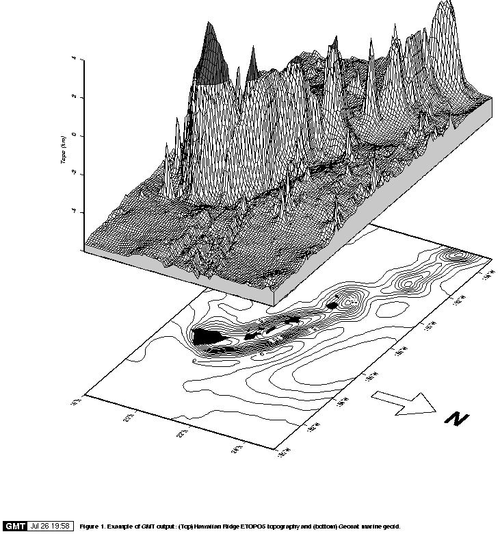
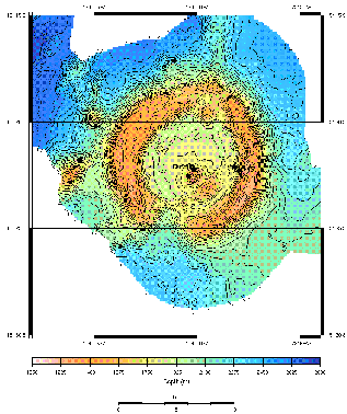
known and used for its advanced plotting and cartographic capabilities (Fig. 1)
|
Figure 1.
Example of the advanced cartographic capabilities of Generic Mapping
Tools (GMT). Composite figure showing 3-D mesh of Hawaiian topography from
ETOPO 5 bathymetry on top of contour map of the Hawaiian geoid. After Wessel
and Smith (1991).
Click on the image for an expanded view
|
ARC/INFO® AND ARCVIEW®
With estimated sales of more than $200 million (Daratech Inc., 1994), the Environmental
Systems Research Institute is the world's largest GIS company. It provides
standalone software in product categories ranging from desktop GIS to high-end,
advanced analytical GIS to software development tool kits. The company's
flagship product, ARC/INFO, is the most commonly used GIS in a variety of
market and scientific research segments, most notably petroleum and mining,
groundwater mapping, geologic mapping, and marine geology. In addition,
ArcView, the company's new desktop GIS, has been tremendously successful, and
provides an easier-to-use, cost-effective addition to ARC/INFO. In addition to
the aforementioned agencies, Arc/INFO and ArcView have been adopted by 40 of
the top 50 oil companies in the world (Petroleum Intelligence Weekly, 1995), is
site licensed on over 100 institutions of higher education in the U.S. (M.
Phoenix, ESRI, pers. comm., 1997), and is in use by companies such as Sea Beam
Instruments, the world leader in the deep ocean seafloor mapping sonar
systems.
GIS packages such as Arc/INFO and ArcView provide not only an efficient means
for mapping and plotting data but also for archiving, manipulating and
analyzing data in relation to other layers or themes of observations. Three
characteristics that distinguish GIS from mapping packages such as GMT are:
- provision of linkages within a relational database management
environment between the locations of points, lines, areas, and/or grids and
detailed descriptive information about them (attributes), along with associated
metadata.
- provision of algorithms for the spatial analysis of data (e.g., spatial
autocorrelation, advection and dispersion modeling, pattern recognition and
analysis, buffering, spatial interpolation, overlay, etc.).
- "spatial intelligence" or the ability to not only change map projections
but to subsequently compute distances, identify nearest neighbors, calculate
regions of proximity around existing features and update their attributes
accordingly.
FUNCTIONAL DESCRIPTION OF ARCGMT
ArcGMT allows users to take advantage of the capabilities of both GMT and
Arc/INFO or ArcView by providing a means for data conversion between the two
environments. This initial version is suited only for UNIX-based workstations
that are also running Arc/INFO version 7.0 or higher, GMT version 3.0 or
higher, and ArcView version 3.0 with the Spatial Analyst extension. ArcGMT
consists of a series of UNIX shell scripts, Arc Macro Language (AML) files, and
Avenue scripts. AML and Avenue are the languages used in Arc/INFO and ArcView,
respectively, to program and tailor those environments. There are two options
for use of the code, depending on which GIS package will be primarily in use,
Arc/INFO or ArcView.
ArcGMT with Arc/INFO
Within the Arc/INFO environment ArcGMT is operated through a simple pull-down
menu from which the user may select to documentation to read or choose from
three types of conversion:
- GMT grids are converted to Arc/INFO grids by writing the binary GMT to an
ASCII file, and then reformatting the file to space-delimited row-major order
and with header information needed by Arc/INFO, including cell size, number of
rows and columns, and coordinates of the grid's lower-left corner. The file is
then piped to the Arc/INFO ASCIIGRID command for conversion to an Arc/INFO
grid.
- Arc/INFO grids are converted to GMT grids by first changing the grid (a
raster data structure) to a vector point coverage. A coverage is
Arc/INFO's primary method for storing point, line and areal geographic
features. Structurally, the coverage is a directory containing binary files
that store the locational coordinates ("Arc") and ASCII database files
that store the locations' attributes and topology ("INFO"). Arc/INFO
coverages and grids can also be read by ArcView. The initial change from
a grid to a point coverage is necessary because each cell in an Arc/INFO
grid is given a value (e.g., depth or elevation) corresponding to an x-y
location on the surface of the earth, but location is inherent in the
storage structure and not explicitly defined as an attribute. A point
coverage derived from a grid, however, explicitly define z-coordinates as
an attribute.
- Arc/INFO coverages may also be converted to text files in a format readable
by GMT scripts. This would be appropriate for features digitized in Arc/INFO,
such as the outlines of lava flows or fault lineations, that would need to be
included in a GMT plotting script. ArcGMT prompts the user for an existing
Arc/INFO line or polygon coverage, converts it to a text file and then
formats it for GMT. Points may just as easily be mapped by GMT with little or
no conversion.
ArcGMT with ArcView
ArcView was introduced in 1994 as a scaled-down, desktop GIS, with a graphical
user interface not available in Arc/INFO, thereby allowing the user to
visualize, explore, and query data much more easily. With a learning curve of
1-5 days (versus 6-12 months for Arc/INFO) many geoscientists have turned to
ArcView as their primary introduction to the world of GIS. Recent revisions to
ArcView have included more powerful spatial analytical capabilities, although
Arc/INFO remains the full-service, industry-standard GIS toolkit. ArcGMT allows
users to make the same conversions described above within the ArcView
environment. This is facilitated by implementing remote procedure calls (RPCs)
between Arc/INFO and ArcView. There are several forms of RPC, but both ArcView
and ARC/INFO use the Open Network Computing standard. RPCs allow client
applications to initiate procedures in a server application across a network.
UNIX RPC servers are uniquely identified by a hostname, a server id, and a
version number. An RPC client application uses this information to establish
the RPC connection. In ArcGMT, ArcView makes client requests to an Arc/INFO
server in the form of Avenue statements. These statements call the ArcGMT
conversion AMLs and shell scripts and then allows the user to import the
results into the ArcView environment. Before using ArcGMT within ArcView, the
user must start Arc/INFO as a server with a simple "&type [iacopen]"
directive and then start ArcView.
Using ArcGMT with ArcView requires the ArcGMT extension ("arcgmt.avx").
Extensions are add-on programs to ArcView (written in Avenue) that provide
additional functionality. When an extension is loaded, ArcView's graphical user
interface changes to reflect this added functionality in the form of additional
menu items, buttons, and/or tools (ArcView tools are distinguished from ArcView
buttons in that the user must go beyond a mouse click and perform an action
with the cursor in order to get a result). The ArcGMT extension adds the
following functionality to the ArcView interface:
- Buttons to perform the three conversions described above, as well as clip
out subsets of grids to create new grids, and create hillshaded themes from
grids (Fig. 2A).
- A tool to create an empty grid based on a rectangle drawn by the user and
the user's specification of row and column numbers (Fig. 2B).
- A menu item (under the "Theme" heading in when a View is active) to
convert an ArcView shapefile (the native ArcView data format) to an Arc/INFO
text file.


|
Figure 2.
(Top) Buttons added to the standard ArcView button bar as part of the
ArcGMT extension to ArcView. From left to right: "Bex (the bathymetry dog)"
converts GMT grids to Arc/INFO grids; "black and white globe" button converts
Arc/INFO coverages to GMT-formatted text files; "color globe" button converts
Arc/INFO grids to GMT grids; "scissors" button extracts a portion of an
existing grid after the user makes a selection with the standard ArcView
rectangle tool; "contour" button creates a hillshaded theme from a grid after
the user opens that theme's legend editor.
(Bottom) A tool added to the standard
ArcView tool bar as part of the ArcGMT extension to ArcView. The tool creates
an empty grid based on a rectangle drawn by the user and the user's
specification of row and column numbers.
|
ArcGMT also comes with an optional ArcGMT project file ("arcgmt.apr") that
automatically opens ArcView with the extension already loaded.
RESULTS AND CONCLUSION
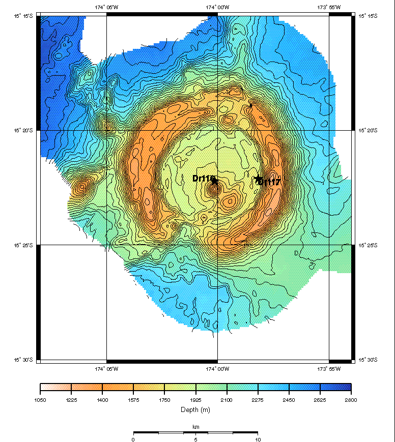
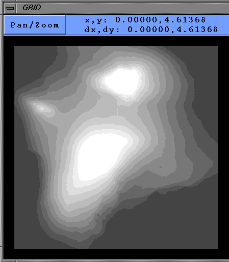
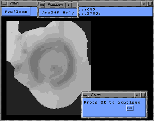
Figure 3 shows the result of a GMT to Arc/INFO grid conversion in ArcGMT. The
original grid was of Sea Beam 2000 bathymetry revealing a seamount in the SW
Pacific discovered in May of 1996 (Wright, Bloomer and
Boomerang Leg 8 Shipboard Scientific Party, 1996). Grid cells were not square due to the
gridding algorithm used when the grid was created with MB-System but ArcGMT was
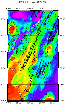
still able to make a perfect conversion. Figure 4 shows a GMT map of Sea Beam
bathymetry overlain with fault lineations that were exported from an Arc/INFO
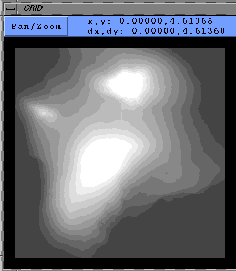
line coverage with ArcGMT. Figure 5 shows the results of an Arc/INFO to GMT
grid conversion in ArcGMT. The original grid was a 1-degree (3-by-3-arc-second
data spacing), 1:250,000 USGS Digital Elevation Model (DEM) of the Big Island
of Hawaii downloaded from the USGS Eros Data Center.
|
Figure 3.
Results of a GMT to Arc/INFO grid conversion in ArcGMT. (Top) GMT
contour map of a GMT grid of Sea Beam 2000 bathymetry from the SW Pacific,
input to ArcGMT for conversion. Data are from Wright, Bloomer
and Boomerang Leg 8 Shipboard Scientific Party (1996). Stars on map show where rocks
were dredged from atop this seamount.
(Bottom)
Screen dump from an ArcGMT session,
showing the same grid after conversion to Arc/INFO format. Grid is displayed in
default grayscale within the GRID module of Arc/INFO.
Click on the image for an expanded view
|
|
Figure 4.
GMT contour map of a GMT grid of Sea Beam bathymetry from the NE
Pacific, overlain with fault lineations that were exported from an Arc/INFO
line coverage by ArcGMT. Data are from the RIDGE Multibeam Synthesis web site.
Click on the image for an expanded view
|
|
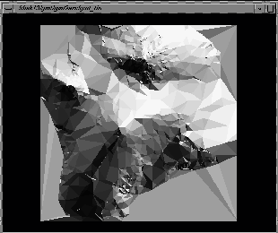
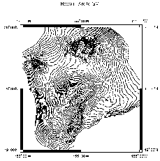
Figure 5.
Results of an Arc/INFO to GMT grid conversion in ArcGMT.
(Top)
A 1-degree, 1:250,000 USGS DEM in Arc/INFO format, displayed in default
grayscale within the GRID module of Arc/INFO. Data are from the USGS Eros Data
Center web site.
(Middle)
TIN construction of the grid using the LATTICETIN command with
analytic hillshading in Arc/INFO before
final conversion to GMT format. This option may be used in ArcGMT if
desired. It is not the default.
(Bottom)
Contour map created in GMT of the resulting GMT grid (100 m contours, annotated
every 500 m).
Click on the image for an expanded view
|
A few cautions apply to Arc/INFO to GMT grid conversions in ArcGMT. The
conversion is designed primarily for elevation or bathymetry data in units of
positive m. If the user tries to convert another kind of grid (e.g., gravity in
mgals), the z value may be off by 1-2 orders of magnitude, which can easily be
remedied with "grdmath" in GMT. USGS DEMs may be in x-y units of decimal
seconds, which are unacceptable units for GMT. Before converting, the user
should always doublecheck the characteristics of the grid with the DESCRIBE
command in Arc/INFO. The grid bounds output by DESCRIBE should be noted by the
user. It may be necessary to project the units
of the grid to decimal degrees and/or to make a datum transformation. In the
case of the USGS DEM of Hawaii, the original WGS72 datum was changed to match a
database stored in NAD83 with the following subcommands in Arc/INFO PROJECT:
output, projection geographic, units dd, datum nar_d three, parameters, end.
Such a three-parameter transformation may result in errors or uncertainty
on the order of ~50 m.
Future improvements to ArcGMT include additional Avenue scripting to
automatically read the hostname of the Arc/INFO server for the ArcView
extension "arcgmt.avx" and allowing the user to interactively test projections,
datum transformations, and various gridding intervals before converting grids
from Arc to GMT.
Source code and a README file for ArcGMT are available here (RIGHT click and "Save As").
Acknowledgments -- This work is supported by the National Science
Foundation under grant OCE-9521039. The paper was improved by the helpful
reviews of two anonymous referees.
REFERENCES
Bobbitt, A. M. (1996) RIDGE Observatory exploration
and data integration using ALVIN and geographic
information systems. RIDGE Events 7(1), 10-12.
Bobbitt, A. M., Dziak, R. P., Stafford, K. M. and Fox, C. G.
(1997) GIS Analysis of oceanographic remotely-
sensed and field observation data. Marine Geodesy
20(2-3), 153-161.
Bobbitt, A. M., Fox, C. G. and Wright, D. J. (1996)
ArcView supports deepsea research with famous
submarine. Proceedings of the 16th Annual ESRI
User Conference, Palm Springs, CA, Paper 082.
Daratech Inc. (1994) New GIS market study. GIM:
International Journal for Surveying, Mapping, and
Applied GIS 8(5), 36-37.
Embley, R. W., Chadwick, W. W., Jr., Jonasson, I. R.,
Butterfield, D. A. and Baker, E. T. (1995) Initial
results of the rapid response to the 1993 CoAxial
event: Relationships between hydrothermal and
volcanic processes. Geophysical Research Letters
22(2), 143-146.
GIS World (1996) 1996 International GIS Sourcebook,
GIS World, Inc., Fort Collins, Colorado, 771 pp.
Hatcher, G. A., Maher, N. M. and Orange, D. L. (1997) The
customization of ArcView as a real-time tool for
oceanographic research. Proceedings of the 17th
Annual ESRI User Conference, San Diego, CA,
Paper 676.
Haymon, R. M., Fornari, D. J., Edwards, M. H., Carbotte, S.,
Wright, D. and Macdonald, K. C. (1991)
Hydrothermal vent distribution along the East
Pacific Rise Crest (9° 09'-54'N) and its relationship
to magmatic and tectonic processes on fast-spreading
mid-ocean ridges. Earth and Planetary
Science Letters 104, 513-534.
Fox, C. G., Bobbitt, A. M. and Wright, D. J. (1996)
Integration and distribution of deepsea
oceanographic data from the NE Pacific using
Arc/Info and ArcView. Proceedings of the 16th
Annual ESRI User Conference, Palm Springs, CA,
Paper 293.
Petroleum Intelligence Weekly (1995) Top 50 oil
companies. Petroleum Intelligence Weekly,
December, 1995.
Wadge, G. (1992a) Geological applications of GIS. Journal
of the Geological Society, London 149, 672.
Wadge, G. (1992b) GIS for geology. Terra Nova 3(1), 93-
98.
Walker, J. D., Black, R. A., Linn, J. K., Thomas, A. J.,
Wiseman, R. and D'Attilio, M. G. (1996)
Development of geographic information systems:
Oriented databases for integrated geological and
geophysical applications. GSA Today 6(3), 1-7.
Wessel, P. and Smith, W. H. F. (1991) Free software
helps map and display data. Eos, Transactions,
American Geophysical Union 72, 441.
Wessel, P. and Smith, W. H. F. (1995) New version of the
Generic Mapping Tools released. Eos, Transactions,
American Geophysical Union 76(33), 329.
Wright, D. J. (1994) From Pattern to Process on the Deep
Ocean Floor: A Geographic Information System
Approach. Ph.D. dissertation, University of
California, Santa Barbara, California, 341 pp.
Wright, D. J. (1996) Rumblings on the ocean floor: GIS
supports deep-sea research. Geo Info Systems
6(1), 22-29.
Wright, D. J., Bloomer, S. H. and Boomerang Leg 8
Shipboard Scientific Party (1996) New Sea Beam
2000 bathymetry and sidescan data from the
Tonga Forearc and Trench: Results from
Boomerang Leg 8, an ODP site survey. Eos,
Transactions of the American Geophysical Union
77(46), F326.
Wright, D. J. and Goodchild, M. F. (1997) Data from
the deep: Implications for the GIS community.
International Journal of Geographical Information
Systems 11(6), 523-528.
Last updated: October 19, 2011
 Go to Dawn's Research