In the developing world, the lack of local technological infrastructure and capacity exacerbate the problem of GIS and spatial data accessibility. Developing countries offer few opportunities for people to receive GIS training and many who obtain those skills leave for better salaries in developed countries. Along with intellectual flight, data access is an equally challenging problem. The benefits of research may never be made practically available in the areas in which the research was done, preventing local resource managers and the general public from using information generated by such projects, and research results may not be translated into the local language (Britton 2000). A web-based GIS can potentially solve some of the problems of spatial data distribution. It has the practical advantage of allowing the users to work with the data on their own terms and pace.
Since this project attempts to solve problems of data distribution and access by publishing research and data on the Internet, it is important to have an idea of what Internet infrastructure exists in American Samoa. There are approximately 13,000 phone lines in American Samoa (CIA 2003). There is one Internet service provider in American Samoa, Samoatelco.com, and free Internet access is available at the Feleti Barstow Public Library in Pago Pago. The public schools in American Samoa received a grant in 2002 to upgrade Internet access to T-1 connections (Bannan 2002). The ASBV works when viewed over a 50 kpbs dial-up Internet connection (although higher speeds are recommended). Although, there are no data available on the level of computer ownership or home Internet access, sufficient Internet users exist in American Samoa that Google, the popular search engine, has established a mirror site in American Samoa.
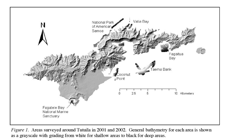
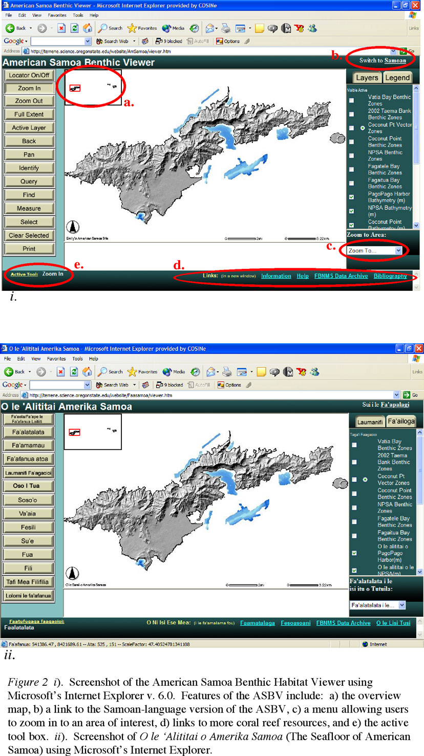
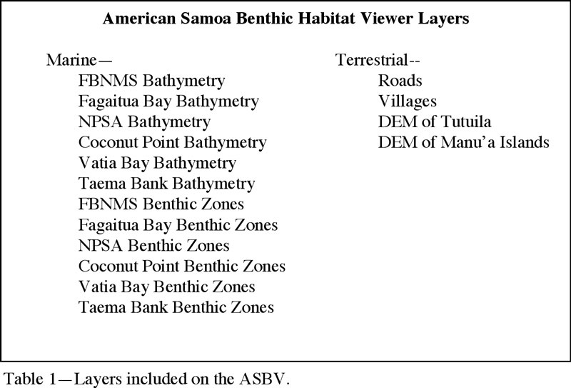
The initial display on the ASBV is a hillshaded digital elevation model of the island of Tutuila along with the bathymetry for seven areas around Tutuila: FBNMS, NPSA, Taema Bank, Fagaitua Bay, Coconut Point, Pago Pago Harbor and Vatia Bay (Figure 2).
The user is then able to add or remove layers as he or she wishes. The featured layers are the benthic zone classifications developed as part of a larger project in the territory (Lundblad et al., 2004). Terrestrial layers such as villages and roads are included to help users orient themselves on the map (Table 1).
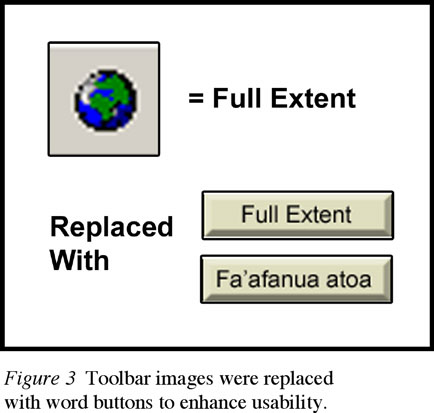
A dropdown menu allows users to zoom directly to one of the areas of focus. To help users unfamiliar with typical GIS tool images, the default toolbar images in ArcIMS were replaced with images containing words (Figure 3).
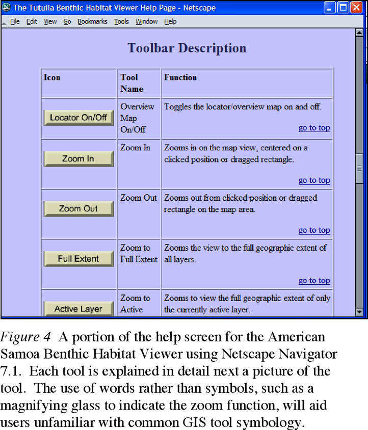
The site has links to other important resources such as the American Samoa Online Bibliographic Database and the Fagatele Bay National Marine Sanctuary GIS Data Archive, where users can download the actual data used to build the site if they have to capability to work with the data (Wright 2001). An extensive help screen has been written to help users unfamiliar with GIS use the site more effectively (Figure 4). To further the aim of public education and outreach, an additional screen has been created with information about the coral reefs in American Samoa and how they were mapped. The coral reef page contains links to sites with more detailed information about coral reefs, should the user be interested in learning more than the ASBV offers.
The ASBV and the Samoan version of the site, along with all data, are currently being hosted at Oregon State University using an Apache 2.0 and Apache Tomcat 4.0 Web Server. There are plans to serve and support the sites locally on Tutuila; however, as of 2004, the technological infrastructure is not at a level where this is possible. The ASBV and its Samoan counterpart are two separate map services with separate .axl files and separate sets of HTML and Java files that reference the same data directories and data. This allows for simpler updates and ensures both sites contain the same content. Changing the display language of an ArcIMS map service is accomplished by changing each display parameter in the Java script file, aimsResource.js.
Although English is the official language in American Samoa, Samoan is still widely spoken. In addition to making the ASBV accessible to as many people as possible, translating the ASBV into Samoan adds to the limited Samoan-language resources available on the Internet. The ASBV is the only Samoan-language web-based GIS in existence and it is one of only a handful of Samoan-language sites dealing with scientific information. Britton (2002) and Crosby et al. (2001) recognized that scientific information translated into the local language greatly improves accessibility and can generate more interest in the subject area by people who would normally be left out of the information distribution process. Currently, few official government web pages are translated into Samoan in either American or the independent nation of Samoa. There are even fewer Internet resources concerned with scientific research in American or independent Samoa and most of these contain little if any Samoan language content. A notable exception is the National Park of American Samoa preliminary online fish inventory, which includes Samoan, English and scientific names for most fish found in American Samoa (National Park Service 2003).
Apache Foundation. Apache Tomcat 4.1. Forest Hill, MD.
Apache Foundation. Apache Server 2.0. Forest Hill, MD.
Bannan, J. 2002. Pacific resources for education and learning: PREL Provides Distance Learning Programming for the Pacific. Pacific Magazine. January. http://www.pacificislands.cc/pm12002/pmdefault.php?urlarticleid=0026 (last accessed 10 February 2004).
Central Intelligence Agency (CIA). 2003. The World Fact Book: American Samoa. http://www.cia.gov/cia/publications/factbook/geos/aq.html (last accessed on 13 February 2004).
Craig, P. Birkeland, C. and Belliveau, S. 2001. High temperatures tolerated by a diverse assemblage of shallow-water corals in American Samoa. Coral Reefs. 20:185-189.
Crosby, M. P., Brighouse, G. and Pichon, M. 2002. Priorities and strategies for addressing natural and anthropogenic threats to coral reefs in Pacific Island Nations. Ocean & Coastal Management. 45:121-137.
ESRI. 2002. Customizing ArcIMS: HTML Viewer. Redlands, CA. Environmental Systems Research Institute.
ESRI. ArcIMS v. 4.0. Redlands, CA.
ESRI. ArcSDE v. 8.2. Redlands, CA.
Fiske, S. J. 1992. Sociocultural aspects of establishing marine protected areas. Ocean & Coastal Management. 17 (1): 25-46.
Gilman, E. L. 1997. Community based and multiple purpose protected areas: A model to select and manage protected areas with lessons from the Pacific Islands. Coastal Management. 25:59-91.
Google American Samoa. http://www.google.as (last accessed on 11 February 2004).
Green, A. L., Birkeland, C. E. and Randall, R. H. 1999. Twenty years of disturbance and change in Fagatele Bay National Marine Sanctuary, American Samoa. Pacific Science. 53 (4): 376-400.
Harris, T. and Weiner, D. 1998. Empowerment, Marginalization, and "Community-integrated" GIS. Cartography and Geographic Information Systems. 25 (2): 67-76.
Lundblad, E., Wright, D., Naar, D., Donahue, B. Miller, J. and Rinehart, R.
2004. The classification of deep water benthic habitats around Tutuila,
American Samoa,
Proceedings of the 24th Annual ESRI User Conference, San Diego, CA, Paper 1458.
National Park Service. Fishes of National Park of American Samoa. http://www.nps.gov/npsa/NPSAfish/ (last accessed on 10 February 2004).
Richmond, R., Kelty, R., Craig, P., Emaurois, C., Green, A., Birkeland, C., Davis, G., Edward, A., Golbuu, Y., Gutierrez, J., Houk, P., Idechong, N., Margos, J., Paulay, G., Starmer, J., Tafileichig, A., Trianni, M., and Vander Velde, N. 2002. Status of the coral reefs in Micronesia and American Samoa: US affiliated and freely associated islands in the Pacific. in Status of Coral Reefs of the World 2002. C. Wilkinson, ed. Cape Ferguson, Queensland: Australian Institute of Marine Science. 378p.
Wright, D. J. 2001. Fagatele Bay National Marine Sanctuary (FBNMS) GIS Data Archive. http://dusk.geo.orst.edu/djl/samoa (last accessed 22 February 2004).
Wright, D. J. 2002a. Mapping and GIS Capacity Building in American Samoa. Proceedings of the 22nd Annual ESRI User Conference, Paper 101, http://dusk.geo.orst.edu/esri02 (last accessed 21 June 2004).
Wright, D. J. 2002b. Mapping the seafloor in American Samoa. Geospatial Solutions. 12 (7): 24-25.
Wright, D. J., Donahue, B. T. and Naar, D. F. 2002. Seafloor mapping and GIS coordination at America's remotest National Marine Sanctuary (American Samoa). in Undersea with GIS. D. J. Wright, ed. Redlands, CA, ESRI Press: 33-63.
Acknowledgments
This research was supported by NOAA Coastal Services Center Integration & Development Initiative, Grant #NA03NOS4730014 to D. Wright. Thanks to Anita Grunder
and Ron Rinehart for continued support.
References and Links
Emily M. Larkin
Graduate Research Assistant
Department of Geosciences
104 Wilkinson Hall
Oregon State University
Corvallis, OR 97331-5506
Telephone: 541-231-7189
Email link
Dawn J. Wright
Professor
Department of Geosciences
104 Wilkinson Hall
Oregon State University
Corvallis, OR 97331-5506
Telephone: 541-737-1229
Fax: 541-737-1200
Email link