Emily R. Lundblad, Dawn J. Wright, David F. Naar, Brian T. Donahue, Joyce Miller, Emily M. Larkin and Ronald W. Rinehart

Classifying Deep Water Benthic Habitats Around Tutuila, American Samoa
Proceedings of the 24th Annual ESRI User Conference, San Diego, CA, Paper 1208, 2004
Track: Ocean, Coastal, and Marine Resources (OCE)
Session: GIS for the Deep Ocean

Coral reef ecosystems are among the most varied on Earth. These valuable ecosystems see danger worldwide, continually facing destruction from anthropogenic effects and natural disasters. Among efforts to understand coral reef ecosystems is the Coral Reef Task Force's objective to map all U.S. coral reefs and, more specifically, to characterize priority deep water (>30m) reef systems in the U.S. and Trust Territories by 2009. This project satisfies that objective for coral reef systems around Tutuila, American Samoa, by using 3D visualization and high-resolution multibeam bathymetry, bathymetric derivatives (bathymetric position index, rugosity, and slope), acoustic backscatter imagery, and in situ visual ground-truthing in an integrated GIS to aid in classifying benthic habitats in Fagatele Bay National Marine Sanctuary, on Taema Bank, and at Coconut Point. Resulting habitat maps establish a classification scheme for American Samoa, point to possible "hot-spots" for biodiversity, and help NOAA's Coastal Services Center develop a deep water benthic habitat mapping tool.

Quick Reference

Understanding and Monitoring Coral Reef Ecosystems
Study Site and its Threats
Data Collection
Development of Classification Scheme for American Samoa
Classification Scheme for BPI Zones
Classification Scheme for Structures
Data Analysis: Bathymetry, Slope, and Bathymetric Position Index
Data Analysis: BPI zone and Structure Classifications
Rugosity Analysis
Results: Application to Fagatele Bay National Marine Sanctuary
Conclusion
Acknowledgements
References
Author Contact Information

Understanding and Monitoring Coral Reef Ecosystems

Marine and coastal environments are a vast frontier for exploration. Coral reefs, along with tropical rainforests, are the most diverse ecosystems on earth. There is a need for documenting baseline information about coral reefs with long-term monitoring and for developing methods to estimate their geographic extent (Miller and Crosby 1998). In the effort to understand and protect ocean resources, several agencies and governmental organizations have been established. In the forefront of strategies and initiatives is the need for seafloor mapping. We need to know the fine-scale terrain of the seafloor in order to locate and study specific resources associated with these particular terrains. The United States Coral Reef Task Force (CRTF) was established by the National Oceanic and Atmospheric Administration (NOAA) in June 1998 as an overseer of coral reef protection. The CRTF Mapping and Information Working Group has a goal to map all United States (U.S.) coral reefs below 30 m depth by 2009 (Evans et al. 2002). The work described here is a first step in meeting that objective for coral reef systems around the island of Tutuila, American Samoa.

The integration of marine data in geographic information systems (GIS) provides a means for advancing marine and coastal research, science and management, geo-referenced mapping, modeling and decision making (e.g., Wright and Bartlett 2000, Valavanis 2002). Geo-referenced habitat-species maps and habitat assessments are essential to marine habitat management (NOAA: USDOC 2002).

Study Site and its Threats

American Samoa, a small, remote territory in the heart of the South Pacific, is the only U.S. territory south of the equator at about a latitude of 14 ° S and a longitude of 168-170 ° W; it lies 4,700 km southwest of Honolulu, Hawaii (Figure 1). It neighbors the independent Nation of Samoa as the eastern portion of the Samoan archipelago. American Samoa's five volcanic islands and two coral atolls are surrounded by the only true tropical reefs in U.S. waters.

Figure 1

Figure 1. Location map of American Samoa. American Samoa is part of the Samoan archipelago and includes 5 volcanic islands and 2 coral atolls (Swains Island not shown in this figure). (Courtesy of the Nat'l Park of Am. Samoa at http://www.nps.gov/npsa/maproom.htm)

The coral reef ecosystems around American Samoa are being threatened by natural and adverse anthropogenic patterns and processes (Evans et al. 2002). Examples of natural threats are coral bleaching, infestation of Crown-of-Thorns starfish and frequent tropical cyclones (Craig 2002, FBNMS 2004, FEMA 2004). Anthropogenic threats such as gill netting, spear fishing, poison and dynamite fishing, non-point pollution and cumulative impacts challenge and stunt coral reef recovery from natural disasters (ASG: DOC 2004).

Data Collection

Extensive data have been collected in American Samoa since 2001 including multibeam bathymetry and backscatter data, towed diver videos, accuracy assessment photography, field notes, and information from a rebreather dive (Wright et al. 2002). Multibeam mapping systems allow surveyors to collect bathymetry by ensonifying massive areas of the seafloor with high accuracy (Mayer et al. 2000). Over 100 acoustic beams form a swath that fans out up to several times the water depth (Figure 2). Multibeam mapping systems are set up on research vessels that navigate across the study area making real-time adjustments for sound velocity, heave, roll, pitch, and speed (~3-12 knots) (Wright et al. 2002). Multibeam mapping systems also collect backscatter data (i.e., the intensity of the acoustic returns). Backscatter data are often useful for classifying seafloor bottom characteristics (e.g., sediments versus lava flows).

Figure 2

Figure 2. Multibeam mapping system geometry. This image portrays the swath of acoustic signals collected by a multibeam bathymetry and backscatter system. (Courtesy of John Hughes Clarke at www.omg.unb.ca/~jhc/HYDRO_I_97/).

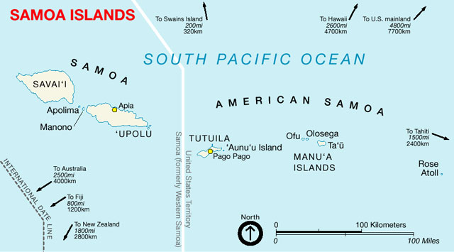
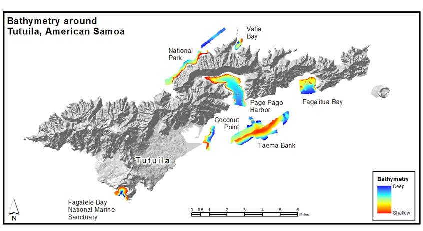
The first scientific surveys of moderate depth (30-150 m) coral reef ecosystems around American Samoa collected bathymetric data from ~3 to 160 m depth in 2001 and 2002 with the University of South Florida's Kongsberg Simrad EM3000, 300 kHz, multibeam mapping system (Wright et al. 2002, Wright 2002). The 2001 survey collected bathymetry and backscatter for Fagatele Bay National Marine Sanctuary (FBNMS), part of the National Park, Pago Pago Harbor, the western portion of Taema Bank, and Faga'itua Bay (Figure 3). Sites surveyed in November 2002 are eastern Taema Bank, Coconut Point, Fagatele Bay, and Vatia Bay (Figure 3). This paper focuses on FBNMS.

Figure 3

Figure 3. High-resolution (1-2 m) Multibeam Bathymetry around Tutuila, American Samoa. Surveys were performed in April and May of 2001 and November of 2002.

Development of Classification Scheme for American Samoa

This study uses multibeam bathymetry coverage around American Samoa to analyze and classify BPI zones, structures and rugosity. Spatial analysis was used to derive slope and multiple scales of BPI from the original bathymetry. The resulting derivative grids were combined with a new algorithm to develop final products: BPI zones, structures and rugosity classification maps for the study site. The maps introduce a new classification scheme based on BPI that may be extended to other coral reef systems. The mapping methods and criteria for classifying benthic zones, including the classification scheme, are summarized in the flowchart in Figure 4. The classification methods identify four BPI zones and thirteen structure classes.

Figure 4

Figure 4. Flowchart of classification methods. This represents methods for classifying BPI zones and structures around American Samoa. The data sets portrayed here are a small region representative of the data set at each study site. The original bathymetry data are used to derive bathymetric position index (BPI) and slope. The derivatives are combined with the original bathymetry in an algorithm to produce benthic maps. The zones and structures are listed with colors that match the legends used in the resulting maps.

Multiple schemes were reviewed for classifications around American Samoa (Coops et al. 1998, Dartnell and Gardner (in press), Greene et al. 1999, Iampietro and Kvitek 2002, Schmal et al. 2003, Speight 1990, Weiss 2001, Zajac et al. 2003). The NOAA/NOS Biogeography Program developed the first classification scheme for U.S. Pacific Islands. In agreement with the NOAA Mapping Implementation Plan (2003), the scheme needs modification for deeper water classifications. Weiss's (2001) landform classes are another valuable classification scheme. Weiss's study classifies slope position and landform types that are predictors of habitat suitability, community composition, and species distribution. In this study, the landform classes are interpreted to describe the seafloor; these can serve as a baseline for future habitat studies. The terminology used in the classification scheme presented here is well-matched with the NOAA/NOS Biogeography scheme for shallow water classifications around the Main Hawaiian Islands (NOAA: NWHI 2003), which was developed using IKONOS imagery and airborne photographic data. This biogeography scheme is being extended into deeper water by scientists at the Coral Reef Ecosystem Division (CRED) of the Pacific Island Fisheries Science Center, who are working primarily with multibeam and underwater video data (Rooney and Miller pers. comm. 2004) in 20-200m water depths. These NOAA classification schemes, the Weiss (2001) landform scheme, and the Speight (1990) scheme, were closely analyzed to develop agreeable terms for the BPI zones and structures that extend below 30 meters depth around American Samoa.

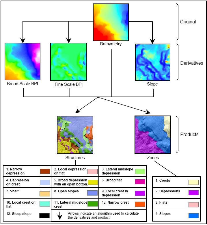
In this scheme, broad refers to seafloor characteristics defined by broad scale bathymetric position index (BPI) grids and fine refers to seafloor characteristics defined by fine scale BPI grids. BPI is described in more detail in the data analysis section.

Classification Scheme for BPI Zones

A surficial characteristic of the seafloor based on a bathymetric position index value range at a broad scale and slope values.
  1. Crests - High points in the terrain where there are positive bathymetric position index values greater than one standard deviation from the mean in the positive direction
  2. Depressions - Low points in the terrain where there are negative bathymetric position index values greater than one standard deviation from the mean in the negative direction
  3. Flats - Flat points in the terrain where there are near zero bathymetric position index values that are within one standard deviation of the mean. Flats have a slope that is <= 5 °.
  4. Slopes - Sloping points in the terrain where there are near zero bathymetric position index values that are within one standard deviation of the mean. Slopes have a slope that is > 5 °. Slopes are otherwise called escarpments in the Main Hawaiian Islands classification scheme.

Classification Scheme for Structures

A surficial characteristic of the seafloor based on a bathymetric position index value range at a combined fine scale and broad scale, slope values and depth.
  1. Narrow depression - A depression where both fine and broad features within the terrain are lower than their surroundings
  2. Local depression on flat - A fine scale depression within a broader flat terrain
  3. Lateral midslope depression - A fine scale depression that laterally incises a slope
  4. Depression on crest - A fine scale depression within a crested terrain
  5. Broad depression with an open bottom - A broad scale depression with a U-shape where the nested, fine scale features are flat or have constant slope
  6. Broad flat - A broad flat area where the terrain contains few, nested, fine scale features
  7. Shelf - A broad flat area where the terrain contains few, nested, fine scale features. A shelf is shallower than 22 meters depth. (This depth value was decided on based on 3D visualization and the Northwest Hawaiian Islands (NWHI) classification scheme (NOAA: NWHI 2003). The NWHI scheme defines a shelf as ending between 20 and 30 meters depth.)
  8. Open slopes - A constant slope where the slope values are between 5 ° and 70 ° and there are few, nested, fine scale features within the broader terrain.
  9. Local crest in depression - A fine scale crest within a depressed terrain
  10. Local crest on flat - A fine scale crest within a broader flat terrain
  11. Lateral midslope crest - A fine scale crest that laterally divides a slope. This often looks like a ledge in the middle of a slope
  12. Narrow crest - A crest where both fine and broad features within the terrain are higher than their surroundings
  13. Steep slope - An open slope with a slope value greater than 70 °

Data Analysis: Bathymetry, Slope, and Bathymetric Position Index

300 kHz multibeam bathymetry data was received for analysis, after post-processing, as a 3-column XYZ ASCII file with positive depth values based on a mean low low water datum at full resolution of the Kongsberg Simrad EM3000 system. For Fagatele Bay, Coconut Point and Taema (Eastern), the XYZ bathymetry was gridded at 1m spacing in MB-System (Caress et al. 1996). MB-System outputs grids in the format of Generic Mapping Tools (GMT) for a UNIX environment. GMT is a public suite of tools used to manipulate tabular, time-series, and gridded data sets, and to display these data in appropriate formats for data analysis (Wessel and Smith 1991). Then the GMT grids were converted to a format compatible with Arc/Info using a suite of tools called ArcGMT (Wright et al. 1998). For Taema Bank (Western), the XYZ data were gridded with Fledermaus and exported as an ArcView ASCII file, then converted to a grid with ArcToolbox. After importing the grids into the Arc/Info raster grid format, algorithms were run in ArcGIS to calculate derivatives.

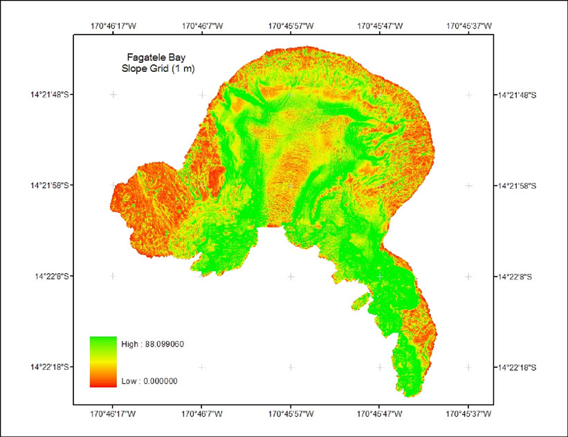
Slope, or the measure of steepness, is simply derived. Output slope values (raster grids) are derived for each cell as the maximum rate of change from the cell to its neighbor. BPI measures where a georeferenced location, with a defined elevation, is relative to the overall landscape by evaluating elevation differences between a focal point and the mean elevation of the surrounding cells within a user defined rectangle, annulus, or circle. BPI is a second-order derivative of bathymetry modified from topographic position index as defined in Weiss (2001) and Iampietro and Kvitek (2002).

The cells in the output grid are assigned values within a range of positive and negative numbers (Figure 5). A negative value represents a cell that is lower than its neighboring cells (valleys). A positive value represents a cell that is higher than its neighboring cells (ridges). Extreme numbers represent more extreme benthic features. Flat areas or areas with a constant slope produce near-zero values. The results of BPI are scale dependent; different scales identify fine or broad benthic features. Conclusions about the structure of the overall seascape can be made with spatial analysis by applying an algorithm that combines grids of different scales with slope and bathymetry

Figure 5

Figure 5. Bathymetric Position Index (BPI). This image portrays topographic position index (TPI) (Weiss 2001) which was used to develop BPI. BPI is > 0 where crests (TPI ridges) exist and < 0 where depressions (TPI valleys) exist. Positions with a constant or near zero slope are ~0 (Weiss 2001).

Data Analysis: BPI Zone and Structure Classifications

First, positive depth values were converted to negative. Slope was derived from bathymetry using the ArcGIS surface analysis. To achieve the best BPI zone and structure classifications several large and small-scale grids were created for each study site. BPI<20> and BPI<250> were used to classify Fagatele Bay and Taema Bank. For Coconut Point, features of interest were identified from about 10 m to 70 m across, so BPI<10> and BPI<70> were used. BPI was calculated in the ArcGIS raster calculator using a focal mean calculation where a cell's elevation is compared to surrounding cells within a user defined area; the resulting grid values are converted to integers to minimize the storage size of the grid and to simplify symbolization (Algorithm 1).

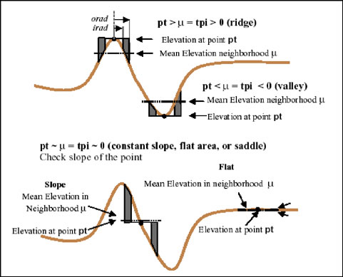
Algorithm 1 creates a BPI grid using bathymetry and user defined radii:

BPI< scalefactor > = int((bathy - focalmean(bathy, annulus, irad, orad)) + .5), where

scalefactor = outer radius in map units

irad = inner radius of annulus in cells

orad = outer radius of annulus in cells

bathy = bathymetric grid

Prior to the classification of the final zones, BPI was standardized by subtracting the mean value and dividing by the standard deviation; the result is multiplied by 100 and then values are converted to integers. The final algorithms for classifying BPI zones and structures are based on combined broad scale and fine scale standardized BPI grids, slope, and depth. In Arc/Info GRID, each of the 13 BPI zones received a unique number as listed in the classification scheme sections. The algorithm uses standard deviation units where 1 standard deviation is 100 grid value units; slope and depth values are defined by the user.

Rugosity Analysis

The rugosity analysis results in descriptive maps that help identify areas with potentially high biodiversity. Rugosity describes topographic roughness with a surface area to planar area ratio. Rugosity was derived with the ArcView Surface Area from Elevation Grids extension (Jenness 2003) using a 3x3 neighborhood analysis to calculate surface area based on a 3D interpretation of cells' elevations. Rugosity values near one indicate flat, smooth locations; higher values indicate areas of high-relief. Rugosity is highly correlated with slope, as seen the results section below.

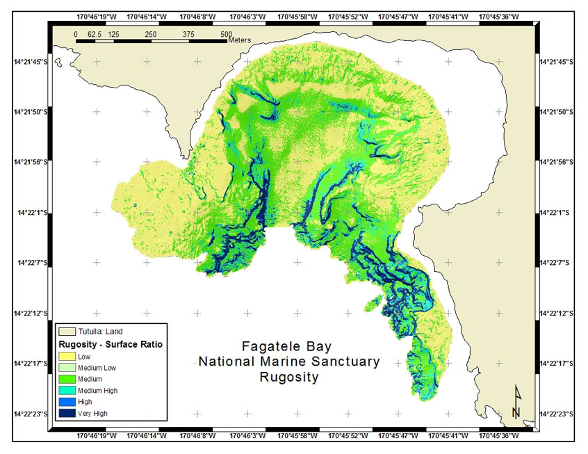
Rugosity classifications extend the classes used by CRED in their 2002 towed- diver surveys. The classes were assigned with the following standard deviation divisions in ArcView® 3.3: Very High (>3 std. dev.), High (2-3 std. dev.), Medium High (1-2 std. dev.), Medium (0-1 std. dev.), Medium Low (Mean), Low (-1-0 std. dev.). Rugosity can be associated with attributes recorded during dives and with comments and attributes recorded in accuracy assessment surveys conducted in 2001 (American Samoa Department of Marine and Wildlife Resources, unpublished data).

Results: Application to Fagatele Bay National Marine Sanctuary

BPI zones, structures and rugosity have been derived for the seven sites around Tutuila where multibeam bathymetry was collected (Figure 3). The results for Fagatele Bay National Marine Sanctuary are shown here. BPI zones are broad surficial features of the seafloor while the structures describe finer features within those zones (Figures 6 and 7).

Figure 6

Figure 6. Fagatele Bay National Marine Sanctuary BPI Zones. UTM, WGS84.

Figure 7

Figure 7. Fagatele Bay National Marine Sanctuary Structures. UTM, WGS84.

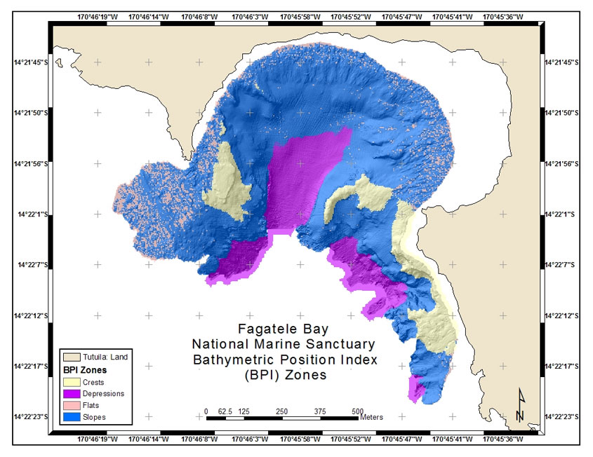
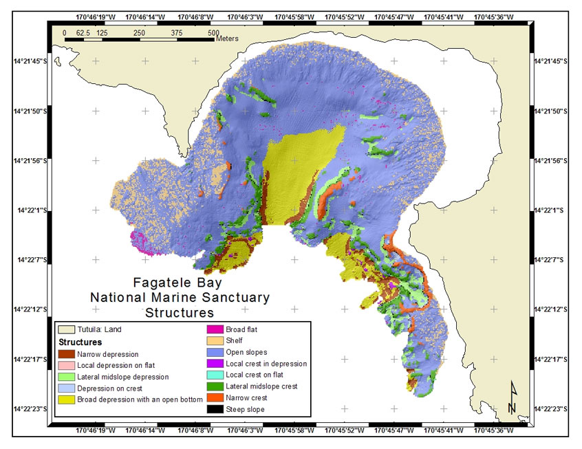
The BPI zones and structures are a baseline of information needed for further studies including submersible surveys that are planned for 2005 (Wright and Naar 2003). They also provide a framework for planning scientific surveys that will give a better understanding of species-habitat relationships and possibly for establishing and monitoring more marine protected areas. The rugosity analysis gives a detailed understanding of where complex features may be hosting high biodiversity (Figure 8). Notice that the highest rugosity values are correlated with the high slope areas and lower rugosity with low slope (Figure 9).

Figure 8

Figure 8. Fagatele Bay National Marine Sanctuary Rugosity. UTM, WGS84.

Figure 9

Figure 9. Fagatele Bay National Marine Sanctuary Slope. UTM, WGS84.

Conclusion

Methods, data and classifications developed in this project will be available in a benthic habitat mapping tool being co-developed with Oregon State University and NOAA's Coastal Services Center (CSC) (Rinehart et al. 2004), from the Fagatele Bay National Marine Sanctuary GIS Data Archive (dusk.geo.orst.edu/djl/samoa), and in Lundblad et al. (in prep. for Marine Geodesy) and Lundblad (2004). They contribute to a national and global investigation of the world's marine and coastal environment. The classifications and associated marine life information are tools for designing management programs for the Fagatele Bay National Marine Sanctuary, the National Park of American Samoa, and other marine reserves in the territory. They are a baseline of information for policy makers and managers to establish a wider and more effective network of marine protection.

Acknowledgments

This research was supported by NOAA Coastal Services Center (CSC) Special Projects for the Pacific Islands Initiative, Grant #NA03NOS4730033 to D. Wright and additional NOAA support to D. Naar. We acknowledge the logistical and financial support from Marine Sanctuary Director, Nancy Daschbach, as well as the warm hospitality provided by the local villages adjacent to Fagatele Bay. Others that were instrumental in this project are Will White (formerly of Department of Marine and Wildlife Resources), John Rooney (CRED), Peter Craig (National Park of American Samoa (NPAS), Allison Graves (formerly of NPAS), Anita Grunder (Oregon State University), Joshua Murphy and Lori Cary-Kothera (CSC), Jeff Jenness (Jenness Enterprises), and Pat Iampietro (California State University, Monterey Bay).

References and Links

American Samoa Government: Deparment of Commerce, 2004, American Samoa Coastal Management Program, http://www.amsamoa.com/coastmgmt.htm

Caress, D.W., Spitzak, S.E., Chayes, D.N., 1996, Software for multibeam sonars, Sea Technology, 37, 54-57.

Coops, N., Ryan, P., Loughhead, A., Mackey, B., Gallant, J., Mullen, I., Austin, M., 1998, Developing and Testing Procedures to Predict Topographic Position from Digital Elevation Models (DEM) for Species Mapping (Phase 1). In CSIRO Forestry and Forest Products: Client Report NO. 271.

Craig, P., 2002, Natural History Guide to American Samoa (Pago Pago, American Samoa: National Park of American Samoa).

Dartnell, P. and Gardner, J. V., in press, Predicting Seafloor Facies from Multibeam Bathymetry and Backscatter Data. In Photogrammetric Engineering and Remote Sensing.

Diaz, J. V. M., 2000, Analysis of Multibeam Sonar Data for the Characterization of Seafloor Habitats. Master of Science Thesis, University of New Brunswick, Fredericton, New Brunswick, Canada.

Evans, D. L., Lautenbacher, C. C. Jr., Mahoney, J. R., Davidson, M. A., 2002, A National Coral Reef Action Strategy. Report to Congress, United States Department of Commerce.

Fagatele Bay National Marine Sanctuary (FBNMS), 2004, Fagatele Bay National Marine Sanctuary Official Site, http://www.fbnms.nos.noaa.gov/HTML/Management.html

Federal Emergency Management Agency (FEMA), 2004, Emergency Managers: National Situation Update - January 2004 Archives, http://www.fema.gov/emanagers/2004/nat010904.shtm

Greene, H.G., Yoklavich, M.M., Starr, R.M., O'Connell, V.M., Wakefield, W.W., Sullivan, D.E., McRea, J.E., Cailliet, G.M., 1999, A Classification Scheme for Deep Seafloor Habitats. Oceanologica Acta, 22(6), 663-678.

Guan, Y. and Flood, R., 2001, Morphologic Analysis of Shinnecock Inlet Using Multibeam Sonar Systems. In Proceedings of the Eighth Conference on the Geology of Long Island and Metropolitan New York, SUNY Stony Brook.

Hall, R.K., Ota, A.Y., Hasimoto, J.Y., 1999, Geographical Information Systems (GIS) to Manage Oceanographic Data for Site Designation and Site Monitoring. Marine Geodesy, 18, 161-171.

Iampietro, P., and Kvitek, R., 2002, Quantitative Seafloor Habitat Classification Using GIS Terrain Analysis: Effects of Data Density, Resolution, and Scale (Conference Poster). (GeoHab 2002).

Jenness, J., 2003, Grid Surface Areas: Surface Area and Ratios from Elevation Grids [Electronic manual]. Jenness Enterprises: ArcView Extensions, http://www.jennessent.com/arcview/arcview_extensions.htm

Lundblad, E., 2004, The Development and Application of Benthic Classifications for Coral Reef Ecosystems Below 30 m Depth using Multibeam Bathymetry: Tutuila, American Samoa. Masters Thesis, Oregon State University, Corvallis, Oregon.

Mayer, L. A., Paton, M., Gee, L., Gardner, J. V., Ware, C., 2000. Interactive 3-D Visualization: A tool for seafloor navigation, exploration and engineering, http://www.ccom-jhc.unh.edu/vislab/PDFs/3DGIS.pdf

Miller, S. L. and Crosby, M. P., 1998, The Extent and Condition of US Coral Reefs. In NOAA's State of the Coast Report. http://state-of-coast.noaa.gov/bulletins/html/crf_08/crf.html

NOAA Biogeography Program (MIP), 2003, Mapping Moderate Depth Habitats of the U.S. Pacific Islands with Emphasis on the Northwestern Hawaiian Islands: an Implementation Plan, v.2, http://biogeo.nos.noaa.gov/projects/mapping

NOAA Biogeography Program (NWHI), 2003. Benthic Habitat Mapping: Northwest Hawaiian Islands Classification Manual, http://biogeo.nos.noaa.gov/projects/mapping/pacific/nwhi/classification/

Rinehart, R., Wright, D., Lundblad, E., Larkin, E., Murphy, J., and Cary-Kothera, L., 2004, ArcGIS 8.x Benthic Terrain Modeler: Analysis in American Samoa. In Proceedings of the 24th Annual ESRI User Conference, San Diego, CA, Paper 1433.

Schmal, ,G.P., Hickerson, E.L, Weaver, D.C., Gardner, J.V., 2003, High-resolution multibeam mapping and habitat characterization of topographic features in the northwestern Gulf of Mexico. In Proceedings of U.S. Hydro 2003 Conference, Biloxi, Mississippi.

Speight, J.G., 1990, Landform. In Australian Soil and Land Survey Field Handbook, 2nd ed. Inkata Press, Melbourne.

Valavanis, V.D., 2002, Geographic Information Systems in Oceanography and Fisheries. (London: Taylor & Francis).

Weiss, A. D., 2001, Topographic Positions and Landforms Analysis (Conference Poster). (San Diego, California: ESRI International User Conference).

Wessel, P., and Smith, W.H.F., 1991, Free software helps map and display data. EOS, Transactions, American Geophysical Union, 72, 293-305.

Wright, D. J., 1996, Rumblings on the Ocean Floor: GIS Supports Deep-Sea Research. Geo Info Systems, 6(1), 22-29.

Wright, D. J., 2002, Mapping the Seafloor in American Samoa. Geospatial Solutions, 12(7): 24-25.

Wright, D.J. and Bartlett, D.J. (editors), 2000, Marine and Coastal Geographical Information Systems. (London: Taylor & Francis).

Wright, D. J. and Naar, D. F., 2003, Travel and Post-Cruise Support for Benthic Mapping in American Samoa, Explore: NOAA Office of Ocean Exploration FY04 Proposal, Oregon.

Wright, D. J., Wood, R., Sylvander, B., 1998, ArcGMT: A suite of tools for conversion between Arc/INFO and Generic Mapping Tools (GMT). Computers and Geosciences, 24(8), 737-744.

Wright, D. J., Donahue, B. T., and Naar, D. F., 2002, Seafloor Mapping and GIS Coordination at America's Remotest National Marine Sanctuary (American Samoa). In Undersea with GIS, edited by Dawn J. Wright. (Redlands, CA: ESRI Press), 33-63.

Zajac, R.N., Lewis, R.S., Poppe, L.J., Twichell, D.C., Vozarik, J., DiGiacomo-Cohen, M.L., 2003, Responses of infaunal populations to benthoscape structure and potential importance of transition zones. Limnol. Oceanogr., 48(2), 829-842.

BACK TO TOP


Emily R. Lundblad
Graduate Research Assistant
Department of Geosciences
104 Wilkinson Hall
Oregon State University
Corvallis, OR 97331-5506
Telephone: 541-737-8818
Email link

Dawn J. Wright
Professor
Department of Geosciences
104 Wilkinson Hall
Oregon State University
Corvallis, OR 97331-5506
Telephone: 541-737-1229
Fax: 541-737-1200
Email link

David F. Naar
Associate Professor
University of South Florida
140 Seventh Avenue South, St. Petersburg, FL 33701
727-553-1637
Email: naar-at-usf.edu

Brian T. Donahue
Research Assistant/Marine Technician
University of South Florida
140 Seventh Avenue South, St. Petersburg, FL 33701
727-553-1121
Email: briand-at-seas.marine.usf.edu

Joyce Miller
Oceanographer
Joint Institute for Marine and Atmospheric Research, University of Hawaii
Contractor to NOAA Pacific Islands Fisheries Science Center
2570 Dole Street, Honolulu, HI 96822
808-592-8303
Email: Joyce.Miller-at-noaa.gov

Emily M. Larkin
Graduate Research Assistant
Department of Geosciences
104 Wilkinson Hall
Oregon State University
Corvallis, OR 97331-5506
Telephone: 541-737-8818
Email link

Ronald Rinehart
Undergraduate Research Intern
Department of Geosciences
104 Wilkinson Hall
Oregon State University
Corvallis, OR 97331-5506
Telephone: 541-737-8818
Email link

BACK TO TOP