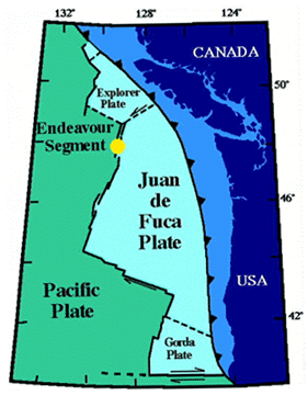
Figure 1.
Index map of the Endeavour Segment, courtesy of Deborah Kelley,
University of Washington.
A Geographic Information System
for the Endeavour Segment
Russell E. McDuff
School of Oceanography
University of Washington
Seattle, WA 98195
|
Figure 1.
|
|
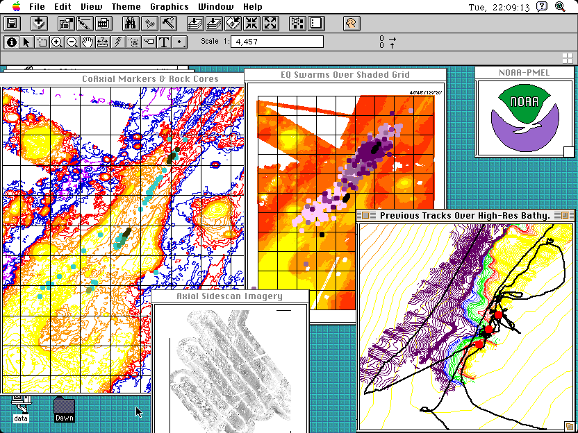
Figure 2.
Screen dump of a demo ArcView session showing various data sets from
CoAxial and Axial. Windows clockwise from top left: (a) Sea Beam bathymetry
at 50-m contour interval overlain with locations of seafloor markers and
rock core sample sites; (b) shaded grid of Sea Beam bathymetry overlain
by 1993 earthquake swarms from SOSUS; (c) NOAA logo; (d) Mesotech bathymetry
at 1-m contour interval overlain with Alvin tracklines and hydrothermal
vent locations; (e) SeaMarc I imagery of Axial Seamount.
Click on the image for an expanded view
|
Project Approach
Development of a user-friendly Web site (www2.ocean.washington.edu/gis)
is underway, that will allow the community to access Endeavour data in various
formats (text, GMT-style grids, and Arc/INFO GIS coverages and grids which are
also readable by the ArcView GIS) and to create online maps using the ArcView
Internet Map Server of the Environmental Systems Research Institute (see an
interactive map gallery of Juan de Fuca data at
newport.pmel.noaa.gov/gis/mapindex.html). The site will eventually link
to other sites maintained by data contributors. The ultimate configuration of
the Endeavour "clearinghouse" will be to provide "one-stop shopping" by
obtaining data from various sources, storing the data on a Web server and
making the data available to end-users. It may also be possible to inventory
analytical procedures developed in recent research projects to integrate
various elements into larger process models.
Each data layer in the Endeavour GIS will be accompanied by a text document containing metadata (a standardized, detailed summary of data layer characteristics, with "pointers" to on-line locations and PI contact information). Metadata creation is in progress using a metadata creation tool for the ArcView GIS that parses text in a format acceptable by the Federal Geographic Data Committee (FGDC). The FGDC oversees content standards for metadata as directed by the new National Spatial Data Infrastructure (Executive Order 12906 signed by President Clinton in April 1994) which has emerged as one of the strongest programs for information resource management at all levels of government (FGDC, 1991). Maintaining FGDC-compliant metadata for Endeavour GIS layers will provide an important linkage to Federal data clearinghouses maintaining similar records, as well as to allied earth science agencies outside of the RIDGE community.
Available Data
Regional Scale
A major source of ridge crest bathymetric data for Endeavour comes from
LDEO's RIDGE Multibeam Synthesis Project. The Endeavour Observatory is located
in "Area 12" of that project. The original data for the RIDGE Multibeam
Synthesis Project Area 12 Grid were collected by NOAA/ORD/ERL/PMEL
investigators from the NOAA ships Surveyor and Discoverer. A link
on the Endeavour GIS site has been provided for users to obtain these data
directly from the Multibeam web site. They can also purchase the RIDGE
Multibeam Synthesis CD-ROM from the RIDGE Office. Wright et al. (in press) have
developed a suite of tools for conversion of GMT-style grids and files to GIS
format and vice-versa, should users wish to integrate RIDGE Multibeam Synthesis
data with existing GIS layers.
In 1996, Deborah Kelley, University of Washington (UW), conducted a survey of the Endeavour Observatory using the Krupp-Atlas Hydrosweep System on the RV Thomas G. Thompson. These data will be available as GMT-style grids and Arc/INFO grids and coverages as ".e00" export files, all with associated metadata.
Segment Scale
The following data sets will be available as available as GMT-style grids,
Arc/INFO grids and coverages as ".e00" export files, and/or text files, all
with associated metadata: swath bathymetry, side-scan sonar images, fixed
transponder locations, magnetics profiles, and water-column CTD profiles.
Vent-Field Scale
Most data collected at the vent-field scale in the Endeavour region (Figure 3)
have been referenced to the University of Washington local Alvin grid.
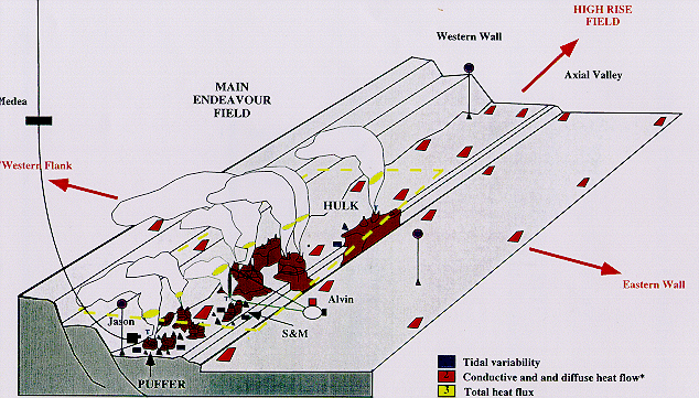
Figure 3. Schematic of Main Endeavour Vent Field from Tivey (1998), showing
sites of future planned experiments in tidal variability, conductive
and diffuse heat flow, total heat flux, acoustic imaging, and plume
processes. Shared-use data from these experiments will be incorporated into
the Endeavour GIS.
As navigational precision (through use of "in-hull" data) and accuracy (by referencing to P-code GPS) have improved, there have been problems with registration of features within the vent field. All data collected here have been converted to UTM Zone 9 using the best location for the origin of the UW local Alvin grid as 47° 53.634'N, 129° 09.871'W. The following data sets will be available as available as GMT-style grids and multi-segment files, Arc/INFO grids and coverages as ".e00 export files, and/or text files, all with associated metadata: Mesotech bathymetry, still imagery, video imagery, submersible dive tracks, samples, fluid chemistry, seafloor markers and geological maps.
Table 1 shows data at the segment and vent-field scales that are currently being processed for incorporation into the Endeavour GIS. We anticipate incorporating additional navigation, pressure sensor, and current meter data from any experiments successfully funded by the May 1998 NSF review panel that will focus on the linkage of hydrothermal heat and mass fluxes to tidal forcing and microbial output (Tivey, 1998).
| Data Type | Year Collected | Archived At | Investigator(s) |
|---|---|---|---|
| Swath Bathymetry | 1984 | NOAA | Johnson/Delaney |
| Swath Bathymetry | 1987 | NOAA | Johnson/Delaney |
| Swath Bathymetry | 1991 | UW | Delaney |
| Swath Bathymetry | 1996 | UW | Delaney |
| DSL-120 Bathymetry | 1991 | UW | Delaney |
| DSL-120 Amplitude | 1991 | UW | Delaney |
| OBS Data | 1988 | UC Davis | McClain |
| OBS Data | 1991 | UC Davis | McClain |
| OBS Data | 1995 | UW | Wilcock |
| SOSUS Data | NOAA | Fox | |
| SeaMARC II | PGC | Davis | |
| SeaMARC II | 1988 | UW | Johnson |
| Magnetics | 1988 | UW | Johnson |
| Magnetics | 1990 | WHOI/UW | Tivey/Johnson |
| Water Column CTD | 198x | NOAA | Baker/Massoth |
| Water Column CTD | 1984 | UCSB | Lupton |
| Water Column CTD | 1986 | UW | Lilley |
| Water Column CTD | 1988 | IOS | Thomson |
| Water Column CTD | 1991 | IOS | Thomson |
| Water Column CTD | 1995 | UW | Lilley |
| Permanent Transponders | UW | Delaney |
| Data Type | Year Collected | Archived At | Investigator(s) |
|---|---|---|---|
| Alvin Dive Still Images | 1984 | UW | Johnson/Delaney |
| Alvin Dive Still Images | 1987 | UW | Baross/McDuff/Lilley |
| Alvin Dive Still Images | 1988 | UW | Delaney/McDuff/Lilley/Baross |
| Alvin Dive Still Images | 1991 | UW | Delaney/McDuff/Lilley |
| Alvin Dive Still Images | 1995 | UW | Delaney/McDuff/Lilley |
| Alvin Dive Still Images | 1997 | UW | Delaney/Fisher |
| Alvin Dive Video Imagery | 1984 | UW | Johnson/Delaney |
| Alvin Dive Video Imagery | 1987 | UW | Baross/McDuff/Lilley |
| Alvin Dive Video Imagery | 1988 | UW | Delaney/McDuff/Lilley/Baross |
| Alvin Dive Video Imagery | 1991 | UW | Delaney/McDuff/Lilley |
| Alvin Dive Video Imagery | 1995 | UW | Delaney/McDuff/Lilley |
| Alvin Dive Video Imagery | 1997 | UW | Delaney/Fisher |
| Alvin Dive Tracks | 1988 | UW | Delaney/McDuff/Lilley/Baross |
| Alvin Dive Tracks | 1991 | UW | Delaney/McDuff/Lilley |
| Alvin Dive Tracks | 1995 | UW | Delaney/McDuff/Lilley |
| Alvin Dive Tracks | 1997 | UW | Delaney/Fisher |
| Alvin Mesotech Bathymetry | 1995 | UW | Delaney/McDuff/Lilley |
| Alvin ESC Imagery | 1991 | UW | Delaney/McDuff/Lilley |
| Jason Dive Track | 1991 | UW | Delaney/McDuff |
| Jason ESC Imagery | 1991 | UW | Delaney/McDuff |
| Jason Video Imagery | 1991 | UW | Delaney/McDuff |
| Jason Mesotech Bathymetry | 1991 | UW | Delaney/McDuff |
| Jason Dive Track | 1997 | UW | Delaney |
| Jason ESC Imagery | 1997 | UW | Delaney |
| Jason Video Imagery | 1997 | UW | Delaney |
| Jason Mesotech Bathymetry | 1997 | UW | Delaney |
| ROPOS Still Images | 1994 | UQAM | Juniper |
| ROPOS Still Images | 1995 | UQAM | Juniper |
| ROPOS Still Images | 1996 | UQAM | Juniper/Fisher |
| ROPOS Video Imagery | 1994 | UQAM | Juniper |
| ROPOS Video Imagery | 1995 | UQAM | Juniper |
| ROPOS Video Imagery | 1996 | UQAM | Juniper/Fisher |
| Geological Map | 1984 | UW | Tivey |
| Geological Map | 1988 | UW | Robigou |
| Geological Map | 1991 | UW | Robigou |
| Macrobiology | 1994 | UQAM | Juniper |
| Macrobiology | 1995 | UQAM | Juniper |
| Macrobiology | 1996 | UQAM | Juniper/Fisher |
| Macrobiology | 1984 | UVic | Tunnicliffe |
| Microbiology | 1987 | UW | Baross |
| Microbiology | 1988 | UW | Baross/Deming |
| Microbiology | 1991 | UW | Baross |
| Microbiology | 1995 | UW | Baross |
| Microbiology | 1997 | UW | Baross |
| Sulfide Samples | 1982 | UW | Delaney/Tivey |
| Sulfide Samples | 1984 | UW | Delaney/Tivey |
| Sulfide Samples | 1988 | UW | Delaney/Goldfarb |
| Sulfide Samples | 1991 | UW | Delaney/Goldfarb |
| Sulfide Samples | 1995 | UW | Delaney |
| Sulfide Samples | GSC | Hannington | |
| Sulfide Samples | 1991 | MBARI | Stakes |
| Basalt Samples | UW | Johnson/Delaney/Karsten | |
| Vent Fluid Chemistry | 1984 | UW | McDuff/Butterfield/Lilley |
| Vent Fluid Chemistry | 1988 | UW | McDuff/Butterfield/Lilley |
| Vent Fluid Chemistry | 1991 | UW | Butterfield/McDuff/Lilley |
| Vent Fluid Chemistry | 1995 | UW | Butterfield/McDuff/Lilley |
| Vent Flow | 1988 | UW | McDuff/Schultz |
| Vent Flow | 1991 | UW | McDuff/Schultz |
| Vent Flow | 1991 | UH/WHOI | Mottl/von Herzen |
| Vent Flow | 1995 | UW | McDuff |
| Vent Flow | 1991 | IOS | Thomson |
| Dive Markers | UW | Delaney | |
| Dive Markers | UQAM | Juniper |
Tracking Our Progress or Contributing Data
We have cataloged, as completely as possible, data sets of which we are aware for incorporation into the Endeavour GIS. Some of these have been provided by the investigators involved and others have been taken from the open literature. If you have a data set that you would like to contribute to this community resource, please e-mail one of the principal investigators: Dawn Wright (dawn@dusk.geo.orst.edu) or Russ McDuff (mcduff@ocean.washington.edu). Comments on the Endeavour GIS web site as it progresses are also welcome via endgis@www2.ocean.washington.edu.
We gratefully acknowledge the support of NSF grant OCE-9633609, and the ongoing labors of Veronique Robigou and Jessica Wilcox at UW, and Hamilton Smillie at Oregon State.
References
Bobbitt, A.M., R.P. Dziak, K.M. Stafford, and C.G. Fox, 1997. GIS analysis of oceanographic remotely-sensed and field observation data, Mar. Geod., 20 (2-3), 153-161.
Federal Geographic Data Committee. 1991. A National Geographic Information Resource: The Spatial Foundation of the Information-Based Society. Federal Geographic Data Committee, Washington, D.C.
Fox, C., Detection and response to a seafloor spreading event, RIDGE Events, 4, 1-2, 24, 1993
Fox, C.G., R.P. Dziak, H. Matsumoto, and A.E. Schreiner, 1993. Potential for monitoring low-level seismicity on the Juan de Fuca Ridge using military hydrophone arrays. Marine Technology Society J. 27(4), 22-30.
National Research Council, Mapping Science Committee, 1990. Spatial Data Needs: The Future of the National Mapping Program. National Academy Press, Washington, D.C.
Spiess, F.N., J.R. Delaney, J.P. Cowen, R.W. Embley, C.A. Fisher, S.K. Juniper, and J.K. Tivey, 1995. Framework and Guidelines for the Juan de Fuca Ridge Seafloor Observatory , RIDGE, Woods Hole, MA.
Tivey, M., 1998. RIDGE Seafloor Observatory Coordinating Meeting Summary, RIDGE, Durham, NH.
Wright, D.J., C.G. Fox, and A.M. Bobbitt, 1997. A scientific information model for deepsea mapping and sampling, Mar. Geod., 20 (4), 367-379.
Wright, D.J., R. Wood, and B. Sylvander, in press, 1998. ArcGMT: A suite of tools for conversion between Arc/INFO and Generic Mapping Tools (GMT), Computers & Geosciences. (dusk.geo.orst.edu/arcgmt)
 Go
to Dawn's Research Page
Go
to Dawn's Research Page