
Page 4 - GIS for Science: Technology Showcase
P. 4
182
GIS for Science
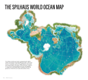
THE SPILHAUS WORLD OCEAN MAP
The Spilhaus world ocean map in a square presents Earth's oceans as a singular, uninterrupted body of water—which they truly are. This unique, ocean-centric perspective of our world was first published in November 1979 by Athelstan F. Spilhaus, a South African-American geophysicist and oceanographer,
in collaboration with Robert Hanson and Erwin Schmid, two geodesists of the former US Coast and Geodetic Survey.
