
Page 41 - GIS for Science: Technology Showcase
P. 41
As the world changes, connected landscapes are more likely to survive than isolated environments. A nationwide green infrastructure model enables conservation groups, nonprofits, businesses, and government agencies to focus on connected open spaces. Their goal is to preserve farmland, habitat, and water quality and promote outdoor recreation, which improves community health and supports local economies.
Green infrastructure resources available from the ArcGIS Living Atlas of the World provide a collection of data and tools to help agencies analyze habitats identified as unfragmented natural areas (also known as cores).
Cores
Cores, larger than 100 acres in size and at least 200 meters wide, are largely undisturbed areas. Maps of these areas include hydrology, species, form, elevation, soils, and ecosystem-related data. The process of creating the national model identified more than 570,000 core areas across the contiguous United States. The cores model generates a high-quality map depicting most intact habitats.
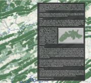
In this map, a set of cores that intersect within the immediate vicinity of Middlesboro, a city in Bell County, Kentucky, are selected. Middlesboro is one of the few cities in the world situated inside what geologists believe is an ancient meteorite crater, or astrobleme. In Middlesboro, this geological phenomenon helps accentuate the arrangement of green infrastructure cores surrounding a human-modified landscape.
Planning
Green infrastructure planning involves the identification and protection of intact habitat cores. The process includes identifying an area’s natural assets for protection, and then determining which natural assets are most critical to the local area. The process starts by identifying large, intact landscape cores. Each core contains more than 50 unique attributes related to its characteristics, of which 21 can be used with the filtering app to create a customizable selection of cores based on variables of interest. By using a built-in weighting model, researchers can generate a ranking score for each core.
Once cores are selected, researchers and planners can access and interrogate the science behind the green infrastructure model by filtering variables associated with the selected set. For example, one such variable is called human modified mean, which measures the degree of human impact upon the landscape. The index ranges from 0.0 for a virgin landscape condition to 1.0 for the most modified areas. The average value for the United States is 0.375.
Scoring
Local scoring allows for the ranking of cores for different projects to make the best use of the national data. Scoring the cores allows planners to further filter out the cores that may not be as important to their project. Applying model weights to each characteristic generates new scores ranking each core. Model weights can be adjusted to emphasize cores with conditions conducive to a project.
Modeling: Ryan Perkl, Esri.
A Glacier in Retreat 225
