
Page 44 - GIS for Science: Technology Showcase
P. 44
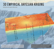
 3D EMPIRICAL BAYESIAN KRIGING
Modeling dissolved oxygen in Monterey Bay
  This 3D map is actually a layer stack of surface models, each depicting ranges of dissolved oxygen levels at various depths in Monterey Bay off the coast of North- ern California. It is easy to see that dissolved oxygen levels vary not only across
each surface but also vertically through the layers.
228 GIS for Science
Data sources: The World Ocean Database (WOD) of the National Oceanic and Atmospheric Administration National Centers for Environmental Information (NOAA NCEI); Esri World Ocean Basemap; Esri World Elevation 3D/TopoBathy 3D. Modeling: Eric Krause, Esri.
