
Page 47 - GIS for Science: Technology Showcase
P. 47
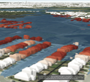
  In this 3D model, the map shows the highest water depth in a simulated 24-hour period for Onion
Creek near Austin, Texas, during a flood. Onion Creek is Austin’s largest watershed and is particularly
vulnerable to flooding. The 3D map uses the National Water Model stream flow forecast.
A Glacier in Retreat
231
