
Page 15 - GIS for Science: Technology Showcase
P. 15
IMAGERY FEATURE EXTRACTION TO IDENTIFY DAMAGED STRUCTURES
Ling Tang and Simon Woo, Esri
Wildfires can spread quickly and destroy thousands of acres of land. In California, where many urban areas infringe on shrublands, these fires often threaten homes and and lives. The 2018 Woolsey Fire—a notably fierce and fast-moving blaze—killed three people, destroyed more than 1,600 structures, forced nearly 300,000 residents from their homes, and burned in total nearly 100,000 acres.
During a disaster, time is essential for response and recovery efforts. Slow response times can result from the lack of timely data and manual interpretation of this data. In these situations, first responders must quickly and accurately identify urban structures fires have destroyed or otherwise spared. This information is vital to first responders, government agencies, and insurance adjusters. The use of drone imagery and Esri’s deep learning tools efficiently processes and analyzes imagery for timely decision support.
As firefighters extinguished flames, drones flew over the burned areas to assess damage. DataWing Global, an aerial data services company and Esri partner, captured 40 gigabytes of on-demand, high-resolution imagery over the Woolsey area. To manage this vast amount of data, a mosaic dataset was created, which allowed responders to display, analyze, and share a collection of images.
Once the data is managed within a mosaic dataset, users can perform deep learning analysis. Deep learning is a subset of machine learning, in which learning is based on an algorithm known as an artificial neural network. Artificial neural networks are computing systems that recognize and learn patterns. Training and deploying a deep learning model involves three steps: creating training samples, training the deep learning model, and running the model inference, which yields a classified map of features.
First, training samples must be created to categorize the damaged and undamaged structures. Building footprints from the Los Angeles County GIS Data Portal were draped over the orthorectified, high-resolution drone imagery, and a new “ClassValue” field was added to the building footprint feature class. Firefighters used this field to identify label buildings as "damaged" or "undamaged." These categorized features were exported using the Export Training Data For Deep Learning tool in ArcGIS® Pro. Training a deep learning model in ArcGIS Pro requires users to set up the Python environment with the necessary deep learning libraries, including PyTorch, Fastai, and library dependencies.
The Train Deep Learning Model tool in ArcGIS Pro used the labeled training samples to train a building damage classification model. The model type is preconfigured as “Feature Classifier” based on the metadata format of the training samples. This geoprocessing tool calls the third-party deep learning application programming interfaces (APIs)—like PyTorch or Fastai—to perform the model training tasks. This tool provides optimal model training parameters for training the damage classification model. The model was trained using a ResNet architecture to classify all buildings in the imagery as either damaged or undamaged. During the model training process, messages regarding training loss, validation loss, and accuracy are generated after each training step. This process allows users to monitor the training progress.
Once the training was complete, the manually assigned ground-truth labels were compared to the model classification results to assess model performance. The results show that the accuracy rate of identifying damaged and undamaged structures was more than 99 percent. The saved model includes the model binary file and the Esri model definition (.emd) file, which can be used to perform model inference in ArcGIS Pro. A zipped deep learning model package (DLPK) file can be shared on the ArcGIS Portal and deployed in ArcGIS Enterprise. Raster analytics (RA) tools can use a DLPK, an item type on Portal for ArcGIS. A DLPK is a compressed file, portable, and easy to use and share.
The Classify Objects Using Deep Learning tool in ArcGIS Pro was used to perform model inference and classify the buildings. Both post-disaster imagery and the building footprint feature class were used as inputs. The result is an updated feature class of the building footprints, with a new ClassLabel field to assign each building as either damaged or undamaged. By running inferencing inside ArcGIS Enterprise using the model and classify objects function in ArcGIS API for Python arcgis.learn module, inferencing can be scaled for large projects by leveraging the RA capability on ArcGIS Image Server.
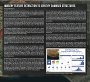
More than 9,000 buildings were automatically classified. Of those, more than 1,300 buildings were deemed as damaged or destroyed by the fire. The resulting map shows the damaged buildings as red and the undamaged buildings as green. With a 99 percent accuracy rate, the deep learning model is as accurate as a trained adjuster and much faster. What usually takes a week was performed in a few hours.
Using the ArcGIS Infographics Add-In, first responders combined analysis with demographic data to further identify at-risk populations, such as children and the elderly. The Infographics report can be generated to quickly provide statistics and other information to assess the magnitude of the situation and help deploy the proper help.
2018 Woolsey Fire Property damage and demographics
This report was created with the ArcGIS Infographics Add-In.
