
Page 34 - GIS for Science: Technology Showcase
P. 34
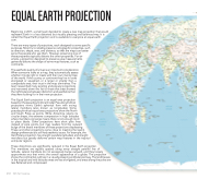
EQUAL EARTH PROJECTION
Beginning in 2017, a small team decided to create a new map projection that would represent Earth in a less distorted but visually pleasing and balanced way. It is called the Equal Earth projection and is available to everyone at equal-earth.
com.
There are many types of projections, each designed to serve specific purposes. Most try to reliably preserve cartographic properties, such as direction, shape, area, and distance, so that the maps can better serve the people who use them. However, preserving one of
these properties typically distorts the other properties. For ex- ample, a projection designed to preserve area measurements generally distorts the shape of some map features, such as continents.
The aesthetic quality of a map is an important consideration. When someone looks at a map, they automatically assess whether it looks right or meets with their own mental map of the world. If the country or continent they live in looks elongated or squashed, or is larger or smaller than a comparable area, their trust in the map diminishes. The team researched many existing and popular projections and narrowed down the list to those that best showed the right balance between distortion and aesthetics that they were looking for in their new projection.
The Equal Earth projection is an equal-area projection
based on the pseudocylindrical model. Pseudocylindrical
projections mimic Earth’s spherical form with arcing
lateral meridians (also known as longitudes). Some pseudocylindrical equal-area projections show the North
and South Poles as points. While Antarctica retains its
circular shape, the extreme compression in high latitudes
where meridians converge means there is not enough room
to place labels. Other projections have short pole lines
instead of pole points, but map readers find the outward
bulge of the lateral meridians of these projections displeasing. These and other projections came close to meeting the team’s design preferences but still had aesthetic issues. For example, the Gall-Peters projection has straight parallels (latitudes) and straight meridians but greatly deforms certain map features in the tropical and polar regions.
These distortions are significantly reduced in the Equal Earth projection.
The meridians are equally spaced along every straight parallel line of
latitude. Lateral meridians do not excessively bulge outward, and they loosely approximate arcs that mimic the overall appearance of a globe. The projection shows the continental outlines in a visually pleasing and balanced way. The landmasses in the tropical and mid-latitude areas are less elongated, and areas along the poles are less flattened and compressed.
 218
GIS for Science
