
Page 52 - GIS for Science: Technology Showcase
P. 52
THE POWER OF STORYTELLING FOR SCIENCE
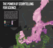
The map shows the gradient of nitrogen surface concentrations (0–10 m; 0–240 μmol L–1) in the Baltic Sea, with highest concentrations close to land and often in proximity to the mouth of major rivers, populated areas, and agricultural land. In the Baltic Sea region, 70–90 percent of the nitrogen originates from agriculture, and is then transported from the fields over the rivers and streams into the sea.
Agricultural land
Populated areas
Major rivers 0
Nitrogen (μmol/l) 240
Sources: CIESIN, HELCOM.
236 GIS for Science
