Toward a New, Updated Arc Marine in 2013
Levels in data modeling include:
reality --> conceptual model --> logical model --> physical model,
increasing in abstraction as one goes from human-orientation to
computer-orientation.
The first step in the data modeling process is to define the overall
scope and content of the model. From a conceptual standpoint, this involves
the challenging task of identifying the common, essential "things"
that are modeled in most GIS projects within your application domain.
Next is the creation of an analysis diagram, with the
identification of major thematic groups and an initial set of object
classes within these groups. The analysis diagram is at the
"conceptual" level in the data modeling process.
Next, an initial model is built in Unified Modeling Language (UML)
and a schema is generated in ArcCatalog. The UML diagrams and schema are
at the "logical" level in the data modeling process. Fortunately the marine
community will not have to deal directly with UML (unless it really wants
to!). Instead, users may take advantage of an existing repository
of CASE tools in order
to generate their own schemas (CASE = computer aided software
engineering, and the tools are for object-oriented design and analysis).
Common Marine Data Types Diagram
JPG Image, 128 K (11/20/06)
Arc Marine Thematic Layers/Globestack
5.4 Mb PDF file (4/26/05)
UML for ArcGIS 10
New!
123 Kb zip file, RT-CLICK, SAVE AS (10/25/11)
UML Diagram for ArcGIS 9.x
Final!
UML, RT-CLICK, 820 Kb Visio file (6/7/06)
MarinePoints |
MarineLines |
MarineAreas |
Time Series & Measurements |
Mesh
UML viewable in HTML
XMI Template for ArcGIS 9.x, RT-CLICK, 1.8 Mb XMI (XML Interchange) file (6/13/06)
To avoid possible parsing errors, you may need to download (rt-click, Save As) this uml.dtd file also, in the same directory as the XMI schema
(in general this file is also resident with the main software within \Program Files\ArcGIS\CaseTools\Utilities - thanks Andra Bobbitt and ESRI Support!)
Make sure you are working within a dedicated folder,
use ArcCatalog to create an empty geodatabase, select that newly-created
database, and then use CASE tools to populate it with the schema in either
the XMI Template (or can use an Mdb repository).
PostGIS SQL Script for Creating an Arc Marine Schema
RT-CLICK, 80 Kb *.sql file (11/17/09 - MANY THANKS to
Yassine Lassoued, Coastal & Marine Resources Centre, Cork, Ireland)
The SQL script above is for use explictly with ArcGIS and can be run in order to create an Arc Marine schema.
PostGIS SQL Script for Creating an Arc Marine Schema w/Auto-Incremental ID fields
RT-CLICK, 84 Kb *.sql file (11/17/09 - MANY THANKS to
Yassine Lassoued, Coastal & Marine Resources Centre, Cork, Ireland)
The SQL script above is for use explictly with ArcGIS and can be run in order to create an Arc Marine schema
with auto-incremental ID fields for the feature classes and tables.
Arc Marine Ontology in OWL
(7/27/07 - MANY THANKS to
Yassine Lassoued, Coastal & Marine Resources Centre, Cork, Ireland)
The above ontology can be browsed with Protege by opening
the OWL file online (using the above URI) or by downloading and browsing locally.
Example Oil Spills Ontology
Example HABs (harmful algal blooms) ontology
Documentation of these ontologies
Arc Marine GML Application Schema
RT-CLICK, 104 Kb *.xsd file (7/22/08 - MANY THANKS to
Yassine Lassoued, Coastal & Marine Resources Centre, Cork, Ireland)
The Arc Marine GML application schema was originally developed for use in the European
InterRisk project for
environmental risk and crisis management in marine and coastal regions.
All Arc Marine elements have been implemented and validated in the schema.
Subset of Arc Marine in XML Schema
(7/10/06 - MANY THANKS to
Eric Rehm, Univ of Washington Applied Physics Lab)
Scientific Information Model Diagram
(1997)
(May help w/ understanding terms/semantics in UML diagram)
GIF Image, 168K
(7/20/02)
Tips & Tricks
Other Data Model Efforts/Standards
Marine XML, Excellent overview report of data models and standards, copyright MarineXML Consortium (uploaded 7/18/08)
British Oceanographic Data Centre (BODC) Data Series Model
MBARI Shore Side Data System
Case Study Schemas, Geodatabases, and Project Files
Updated 04/22/08
Please note that the projects and geodatabases provided here are
not exhaustive of all the various marine GIS applications that are
possible! Additional databases will be added as more
groups implement the model.
Arc Marine case study participants did NOT modify the core data model by removing fields, changing relationships, and generally
using feature classes and tables for something other than what they were intended for. They DID add their own attributes, tables and relationships, without taking away or modifying those that
were already in the model. One of the reasons for keeping the core intact
is so that developers can code software tools that take advantage of known
entities in the database. For example, if certain attributes are removed from
core feature classes or tables, new software tools (such as DHI's TimeSeries
manager) will not work properly.
Chapter 3 - Marine Surveys
Seafloor Mapping and Benthic Habitat Mapping, Massachusetts Continental Shelf
Brian Andrews and Seth Ackerman, USGS Woods Hole,
w/ MA office of Coastal Zone Management
Full Details in USGS Open File Report
-- Case Study Repository, ArcMap file, and Data (6/13/07)
-- ESRI UC 2005 Poster with schema (8/9/05, 6.5 Mb)
-- Case Study PPT (5 Mb)
-- Further Background on Project
Chapter 3 - Marine Surveys
USGS Louisiana Subsidence (Sediment Coring, Cruise Data Mgmt)
Heather Mounts, Photo Science Inc. (formerly with GIS Solutions, Inc.)
-- Case Study Repository
(16 Mb .mdb)
-- Case Study PPT (6 Mb)
-- Background on Project
-- Background on Data (6 Mb PPT)
Chapter 4 - Marine Animal Data Applications
Whale/Turtle/Seal Tracking
Pat Halpin, Best Best, Ei Fujioka, and Michael Coyne, Duke Univ.
-- Contact Pat Halpin/Ben Best for schemas and fully populated GDBs
-- Case Study PPT (18 Mb)
Chapter 5 - Implementing Time Series and Measurements
Marine Institute (Ireland) Case Study
Martina Hennessy, Marine Institute (now with Microsoft-Ireland), and
John Evans, Trevor Alcorn of the Marine Institute, with Damian Smyth, ESRI-Ireland
-- Case Study Visio of UML (1.1 Mb zip)
Chapter 6 - Nearshore and Coastal/Shoreline Analysis
Hawaiian Reef Fish Analysis
Alyssa Aaby, Dawn Wright, OSU, with Brian Tissot, Washington State University
-- Case Study Repository (68 Mb .mdb)
-- Case Study PPT (4 Mb)
-- ESRI
UC 2004 Conference Paper
Chapter 6 - Nearshore and Coastal/Shoreline Analysis
Pacific Island Coral Reefs - Pacific Islands Network
Lisa Wedding, National Park Service, Pacific Islands Coral Reef Program
-- Case Study Schema (1.2 Mb XMI)
-- Copy of Case Study Schema in xml (1.6 Mb xml)
-- ESRI UC 2005 PPT File (14 Mb) - w/ L. Basch, M. Lane-Kamahele, G. Dicus, S. Margriter
Chapter 6 - Nearshore and Coastal/Shoreline Analysis
Advancement of an Enterprise Coastal GIS in Martin County, Florida
Kathy Fitzpatrick, Coastal Engineering Department Martin County, FL;
Rob Hudson and Heather Mounts, Photo Science, Inc.;
Alexandra Carvalho, Taylor Engineering (now at CMar Consulting, LLC);
Ken Craig, Taylor Engineering;
Echo Gates, Florida Department of Environmental Protection; and
Northstar Geomatics, Inc.
-- Case Study Visio of UML (1.2 Mb zip)
-- Case Study Repository (356 Mb .mdb)
-- Case Study Geodatabase Schema Report (25 Kb zip)
-- Case Study Inventory of Data (26 Kb zip)
-- Case Study Raster Data (12.3 Mb zip)
-- Case Study PPT (5.5 Mb)
-- 2004 ESRI UC Conference Paper
Chapter 6 - Nearshore and Coastal/Shoreline Analysis
Integration of Model Results and GIS with the Marine Data Model (Sediment Budget and Coastline Evolution)
Michael Blongewicz, DHI-Water & Environment (now w/TomTom)
-- Contact Michael Blongewicz for schemas
-- Case Study PPT (3.7 Mb)
-- Implementing Measurements and Time Series with the MDM (539 kb PPT)
Chapter 7 - Model Meshes
Federal Maritime and Hydrographic Agency (GERMANY) Case Study
Michael Blongewicz, DHI-Water & Environment and Juergen Schulz-Ohlberg, BSH
-- Case Study Visio of UML (2.3 Mb zip)
-- Case Study Repository, ArcMap file, and Sample Data (10.5 Mb zip)
ADDITIONAL Case Studies
Updated 02/07/12
Utilizing Arc Marine Concepts for Designing
a Geospatially Enabled Database to Support Rapid Environmental Assessment
Defence R&D Canada - Atlantic
Anthony Isenor and Tobias Spears
-- Link to technical report
Whale Tracking
Oregon State University M.S. Thesis
Brett Lord-Castillo
-- Link to thesis and schemas
Arc Marine/Arc Hydro Integration
Classroom experiment, University of Washington
Tim Nyerges et al.
-- Coastal Zone '07 paper (pdf)
BIDI (BIological Data Integration) for the Marine Institute, Ireland
Coastal and Marine Resources Centre, Cork, Ireland
Yassine Lassoued et al.
-- Link to site and schemas
GeoDI (Geological Data Integration) for the Marine Institute, Ireland
Coastal and Marine Resources Centre, Cork, Ireland
Yassine Lassoued et al.
-- Link to site
BACK TO TOP
Last update: February 21, 2014
© 2001-present, D. Wright and OSU Webworks
http://dusk.geo.orst.edu/djl/arcgis/diag.html
|

;) Conceptual framework portion of original analysis diagram by S. Grisé
Conceptual framework portion of original analysis diagram by S. Grisé;) Data, data, data! For example, this is a
graphic of the long-term
ecosystem observatory instruments and platforms of
the Rutgers U. Coastal Ocean Observation Lab
Data, data, data! For example, this is a
graphic of the long-term
ecosystem observatory instruments and platforms of
the Rutgers U. Coastal Ocean Observation Lab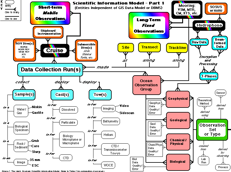