GeoDI:
Geoscientific Data Integration, an integrated, flexible, scalable geoscientific data
model and ontologies based on Arc Marine. See also
GeoDataOnline
Federal/State Mapping Program
Supports Ocean Management
and Research, Federal GIS Connections, ESRI Newsletter, Summer 2008, Brian Andrews & Seth Ackerman, USGS
We appear in
OceanTeacher, International Oceanographic Data and Information Exchange (IODE) Programme of the Intergovernmental Oceanographic Commission of UNESCO
ArcGIS Data Model Support Site & Other ArcGIS Data Models
Marine Data Model Companion Site
Arc Hydro Online Support System
Arc Hydro USA ToolSet
Groundwater Data Model
Data Model Discussion Forum
ArcGIS Raster Data Models
Atmospheric Data Model
Climate Change GIS Data Portal
"Benthic Movies", Bass Strait, Australia
Chris Jenkins, INSTAAR, UC-Boulder and Tanya Jenkins, Sydney University
CalCOFI Data Archive
mostly physical oceanographic data
Davey Jones' Locker
Oregon State University College of Earth, Ocean, and Atmospheric Sciences
Digital Geologic Map Data Model
USGS and Assoc. of American State Geologists
Duke University Geospatial Analysis Program
Landscape/seascape ecology, conservation planning
Duke University Marine Geospatial Ecology Lab
including marine ecosystem-based management tools
Ecological Marine Units
ESRI Marine Conservation Page (legacy)
ESRI Ocean Industry Site
Geographic Information Systems in Oceanography and Fisheries
published by Taylor & Francis
Issue Related to ArcMarine:
Dangers of Plastic Pollution to Marine Life
Thanks to Anna Quinn and daughter for the link!
Marine & Coastal Geographical Information Systems
published by Taylor & Francis
Foreword by Mike Goodchild
Marine & Coastal GIS Links from Davey Jones Locker
NOAA Office for Coastal Management
NOAA Tampa Bay Bathy/Topo/Shoreline Demonstration Project
Thanks to Robby Wilson, NOAA Office of Coast Survey
Ocean Advocacy Letter to Jack Dangermond (U.S.-legacy)
Part 1 |
Part 2 |
Part 3 w/ signatures
Ocean Advocacy
II (European-legacy)
OBIS - Ocean Biogeographic Information System
OBIS-SEAMAP (Duke University)
Updated!
Place Matters: Geospatial Tools for Marine Science Conservation and Management
published by OSU Press
Foreword by Sylvia Earle
STORMS-LK
Navy knowledge representation model for meteorology
Thanks to Craig Kelly, Naval Oceanographic Office
Theory Underlying Concept Mapping
Thanks to Kimberly Reid
Undersea with GIS
published by ESRI Press
Foreword by Sylvia Earle
Press Release
Unified Modeling Language (UML)
(ESRI UML is slightly different from standard UML!)
Visio
(for best results get Professional with the Enterprise Network Tools add-on!)
World Ocean Database |
World Ocean Atlas
BACK TO TOP
Last update: November 20, 2017 and NO LONGER UPDATED
© 2001-present, D. Wright and OSU Webworks
http://dusk.geo.orst.edu/djl/arcgis/links.html
|

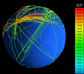 Visualization of Internet traffic flows by
S.G. Eick - featured in M. Dodge's Atlas of Cyberspace
Visualization of Internet traffic flows by
S.G. Eick - featured in M. Dodge's Atlas of Cyberspace
;)
;)
;)