
Page 7 - GIS for Science: Technology Showcase
P. 7
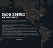
 COVID-19 DASHBOARDS
MONITORING A PANDEMIC
Derek Lawi, Esri
In December 2019, an outbreak of a pneumonia-like disease was reported in Wuhan City, China.The virus was named COVID-19. By the time the virus was properly identified by the World Health Organization (WHO) and Centers for Disease Control (CDC), coronavirus cases were reported in other regions of China and beyond.
In early February 2020, Lauren Gardner, director of the Center for Systems Science and
Engineering and a civil engineering professor at Johns Hopkins University (JHU), led a team to create a dashboard showing the coronavirus outbreak. Its objective was to use the dashboard to help monitor and visualize reported cases on a global scale.
The JHU Coronavirus COVID-19 Global Cases Dashboard reports case locations and key performance indicators, such as confirmed cases, deaths, and recoveries. Confirmed cases can be filtered by country, and, in the United States, further filtered by state. Serial charts show data trends over time.
By early March, many other countries began reporting COVID-19 cases. Several hundred different dashboards have been created to help monitor the outbreaks. Some are designed for country-specific or, in the United States, state-level data. Variations of the dashboards have also been created to support viewing on mobile devices..
Additional publishers of public COVID-19 dashboards include WHO; United Nations World Food Programme–Division of Emergencies; Philippines Department of Public Health; Singapore Ministry of Public Health; Thailand Ministry of Public Health; the United Kingdom Department of Public Health; the Government of Hong Kong; JAG Japan Corp (an Esri partner); and Esri offices in Germany, Korea, Hong Kong, Portugal, Spain, and Turkey.
To learn more about ArcGIS Dashboards and visit the live apps mentioned above, visit:
GISforScience.com
