|
Plus...
ESRI User Conference, July 2009, San Diego
Arc Marine Technical Workshop
ESRI User Conference, June 2007, San Diego
Coastal Zone '07, July 2007, Portland, OR
Additional Case Study: Arc Marine/Arc Hydro Integration (pdf conference paper, Nyerges et al.)
ESRI User Conference, August 2006, San Diego
Arc Marine Technical Workshop
September 2005
DHI release of
MIKE Marine GIS |
Temporal Analyst for ArcGIS
ESRI User Conference, July 2005, San Diego
Coastal GeoTools, March 2005, Myrtle Beach, SC
Poster abstract
ESRI User Conference, August 2004, San Diego
Association of American Geographers Centennial Meeting, March 2004, Philadelphia
Feature in
GIS Cafe Weekly Magazine, October 6-13, 2003
Oceans 2003 Poster Presentation, September 25, 2003, San Diego
Abstract
ESRI User Conference, Data Model Technical Workshop, July 9, 2003, San Diego
Third Workshop, May 16-18, 2003, ESRI Redlands
Chapter in
Marine Geography
- 684 K pdf,
by J. Breman, D. Wright, P. Halpin
Web Conference of the Working Group, Major Updates to Model, Nov 1, 2002
- Screen Shots of ArcGIS Demo by Michael Blongewicz, DHI - 6.9 Mb PPT file
ESRI User Conference, Marine SIG Meeting, Jul 9, 2002, San Diego
- Minutes | printable MS-Word doc
- Introducing the Model - 1.3 Mb PPT file
- Data Types for the Model - 8.3 Mb PPT file
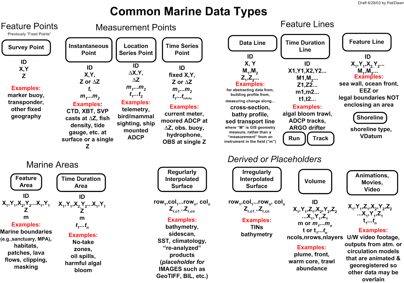
Common Marine Data Types Diagram
Scientific Information Model Diagram
from 1997 Marine Geodesy article
Second Workshop, Jun 7-8, 2002, ESRI Redlands
- Minutes | printable MS-Word doc
- ArcGIS
Interest Database, (as of 7/18/02), 49K, MS-Excel file
- Comments from Halcrow, Ltd., 23K MS-Word file
Introductory PPT Presentation, Jun 7
- or download original PPT file,
2.0 Mb
Data PPT Presentation, Jun 7
- or download original PPT file,
8.3 Mb
Initial Working Group Meeting, Oct 4-5, 2001, ESRI Redlands
- Minutes |
printable MS-Word doc
-
Joe Breman's General ESRI Marine GIS/Data Model PPT, 15.3 Mb file
-
Marine and Coastal Framework Data, 8.5 Mb PPT file
-
Additional Ideas for the ArcGIS Ocean Data Model, 1.4 Mb PPT file
Creating a Customized Raster Format DLL
Discusses better methods for incorporating NetCDF and
other raster formats into ArcGIS 8.x, 9.0, and 9.1 without the hassles of data conversion! Reading of climate and forecast (CF) NetCDF files is anticipated in ArcGIS 9.2 "Raster
support in ArcGIS is built on an open structure based upon the DLL technology.
With this open structure, users can add their own format support into ArcGIS by creating
a customized DLL and plugging it into ArcGIS. The customized raster format, created
by implementing some predefined interfaces, will be treated the same as other built-in
raster formats. ArcGIS 8.2 supports the following raster formats out-of-the-box: TIFF,
GRID, GRID Stack, ADRG, DTED, ERDAS LAN, ERDAS GIS, BMP, GIF, IMAGINE Image, JPEG, MrSid,
ERDAS RAW, ESRI BIL/BIP/BSQ, ERMapper, PNG, SDE Raster, NITF, CIB, CADRG formats. If
you have rasters that are stored in a format other than the formats listed above and
want to apply those rasters in ArcGIS or ArcIMS, building a customized DLL is the way to go."
Data Management for Marine Geology & Geophysics
NSF-ONR Workshop Report, May 2001 (7 Mb PDF file)
Moving GIS Into the Ocean Realm...
ESRI white paper (196K PDF file)
Hydrographic Data Management using GIS Technologies
ESRI white paper (500 PDF file)
Multiuser Geographic Information Systems with ArcInfo 8
Discusses the characteristics successful
geodatabase implementation, including data models (with some info.
on UML), database tuning, data loading procedures, and well-designed
applications for working with the data.
ESRI white paper (1.2 Mb PDF file)
National Hydrography Data Content Standard for Coastal and Inland Waterways
FGDC MCSD Subcommittee (604K MS-Word file)
A Scientific Information Model for Deepsea Mapping and Sampling
article in Marine Geodesy, 1997
BACK TO TOP
Last update: September 22, 2012
© 2001-present, D. Wright and OSU Webworks
http://dusk.geo.orst.edu/djl/arcgis/docs.html
|

