|
This site provides GIS data from shallow-water multibeam bathymetric
surveys, submersible dives, and workshops
conducted in 2001-2005 in support of the Fagatele Bay National Marine Sanctuary,
American Samoa (now known as the National Marine Sanctuary of
American Samoa) in the SW Pacific Ocean. Most shallow high-resolution multibeam
bathymetric data were collected with a Kongsberg Simrad EM3000 system owned
and operated by the College of Marine Science,
U. of South Florida. Also included is a recent compilation of deepwater
bathymetry for the entire Eastern Samoan region, as well as
terrestrial GIS data layers obtained from the American Samoa GIS User Group,
and other sources. In addition, we offer various Generic Mapping Tools
GMT grids,
maps, and various photographic images and graphics.
Please note that shallow bathymetric grids
have not undergone corrections for differential GPS.
We also have 2009 Samoa Tsunami Resources available, as well as a
Featured Gallery in Data Basin.
American Samoa Pelagic Fishery Management Boundary GIS file and metadata, courtesy of Robert O'Conner of NOAA.
Digital Raster Graphics (DRGs) w/metadata of West Tutuila and East Tutuila courtesy of Jonathan Levy, Oceanit (sample graphic).
Important!
Have old style GMT grids that need to get into ArcGIS 9/10? In current GMT do: grdreformat -fg oldformat.grd newformat.nc
Still Hot!
See and download our PUBLICATIONS and THESES, many of which are peer-reviewed, as well as the NOAA NCCOS Samoa Biogeographic Assessments.
Neat!
2014 National Park of American Samoa Climate Change Research Map, showing
forest study plots on Tutuila installed every 70 m, or every 200 to 300 ft. in
elevation change.
NOAA PIFSC Summary of Geospatial Data and Habitat Mapping in American Samoa, May 27, 2015
PacIOOS Voyager Bathy Data for American Samoa
To download a file, PC or Unix users should hold
down the RIGHT mouse button and then choose "Save Link As" or "Download Link to Disk" (Internet Explorer). Mac users should
hold down the mouse button and then choose "Save Link As" or "Download Link to Disk". In the table below, "NA" means "
not available." On a very limited basis we may be able to burn sets of
CDs containing all of the bathymetric data sets. Email
Dawn for more info.
The data resources (including thumbnail graphics, FGDC metadata, and
ArcGIS data files) listed below for direct download from this web site are
made available under the CC0 1.0 Universal (CC0 1.0) Public Domain Dedication
license available online here:
Creative
Commons CC0 "No Rights Reserved"  . If rights are needed to photos or any other material
from this web site, please contact Dawn Wright by email at DWright-at-esri.com. . If rights are needed to photos or any other material
from this web site, please contact Dawn Wright by email at DWright-at-esri.com.
For valuable information and downloads of recent and ongoing shallow-water
multibeam, towboard, and ROV surveys in American Samoa, see also the web site
of the
NOAA Pacific Islands Benthic Habitat Mapping Center (PIBHMC), based in Honolulu, HI.
Quick Links / Categories
Bathy |
3-D |
GMT grids |
Maps/Graphics
Scroll Down for:
Boundaries |
Coastlines |
Contours |
DRG |
Geology |
Hydrography |
Infrastructure |
Reefs |
Regional |
TopoGrid |
Vegetation
American Samoa GIS Users: After downloading, please consider the
recommended, standardized AS GIS User Group directory structure. Click here (pdf file).
GIS Data Layers
|
TUTUILA NEARSHORE BATHY DERIVED FROM IKONOS |
|
DATA SET |
THUMBNAIL GRAPHIC |
FGDC METADATA |
DOWNLOAD FILE |
|
Tutuila Nearshore Bathy Grids |
figure 1
figure 2
figure 3
|
metadata 1
metadata 2
error analysis
|
ArcGIS grids
with pdf maps
(Rt click-Save As
72 Mb zip)
|
|
AMERICAN SAMOA COASTAL TERRAIN MODELS (CTMs) (combined bathy and land terrain) |
|
DATA SET |
THUMBNAIL GRAPHIC |
FGDC METADATA |
DOWNLOAD FILE |
|
Tutuila CTM |
figure |
metadata
M.S. Thesis
|
ArcGIS grid
(Rt click-Save As
68.1 Mb zip)
|
| Other formats |
|
|
ESRI ASCII file
(190 Mb)
|
|
Ofu-Olesega Bathy Derived from Ikonos w/ Multibeam |
figure |
Read Me file
metadata 1
metadata 2
|
ArcGIS grid and more
(Rt click-Save As
22.3 Mb zip)
Maps & Error Analyses
|
See below for American Samoa CTM
PDF Maps
|
|
|
|
|
EASTERN SAMOA BATHYMETRIC COMPILATION |
|
DATA SET |
THUMBNAIL GRAPHIC |
FGDC METADATA |
DOWNLOAD FILE |
|
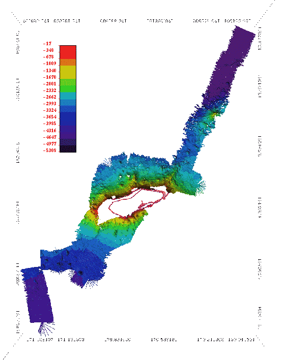
E. Samoa Compilation, Lat/Long, 200-m grid |
figure |
metadata
M.S.
Thesis
|
ArcGIS file
(Rt click-Save As
1 Mb)
|
| Other formats |
|
|
GMT grid
(Rt click-Save As, 9.6 Mb)
|
| E. Samoa Compilation Stats (Excel files) |
|
|
Multibeam Index
Seamount Stats
|
See below for E. Samoa
3-D Fledermaus,
GMT Grid Subsets,
PDF Maps
|
|
|
|
|
OTHER BATHYMETRIC GRIDS (mostly shallow bathy) |
|
DATA SET |
THUMBNAIL GRAPHIC |
FGDC METADATA |
DOWNLOAD FILE |
|
Coconut Point Bathymetry, UTM, 1-m grid |
figure |
metadata
|
ArcGIS grid
(Rt click-Save As)
|
|
Email for Coconut Pt. Rugosity, BPI Zone/Structure, Slope, Aspect grids
|
Fagaitua Bay Bathymetry, Lat/Long 1-m grid
(for benthic habitat)
|
fagai.gif
|
fagaitua1m.htm
|
fagaitua1m.zip
(842 K)
|
Fagaitua Bay
BPI Zones Grid
|
See Maps below
|
metadata
|
ArcGIS grid
(Rt click-Save As)
|
|
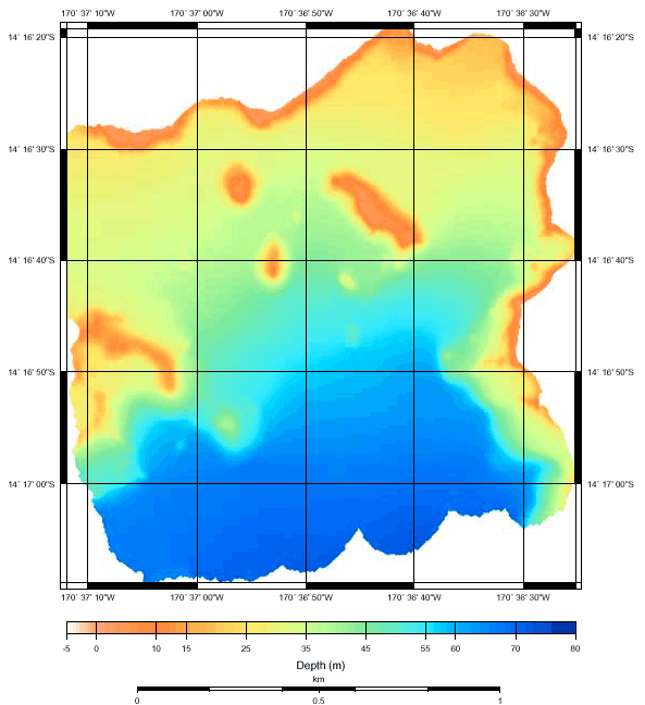
Fagatele Bay Bathymetry, UTM, 1-m grid |
figure |
metadata
|
ArcGIS grid
(Rt click-Save As)
|
|
Fagatele Bay Bathymetry, UTM, 3-m grid |
figure |
metadata
|
ArcGIS grid
(Rt click-Save As)
|
|
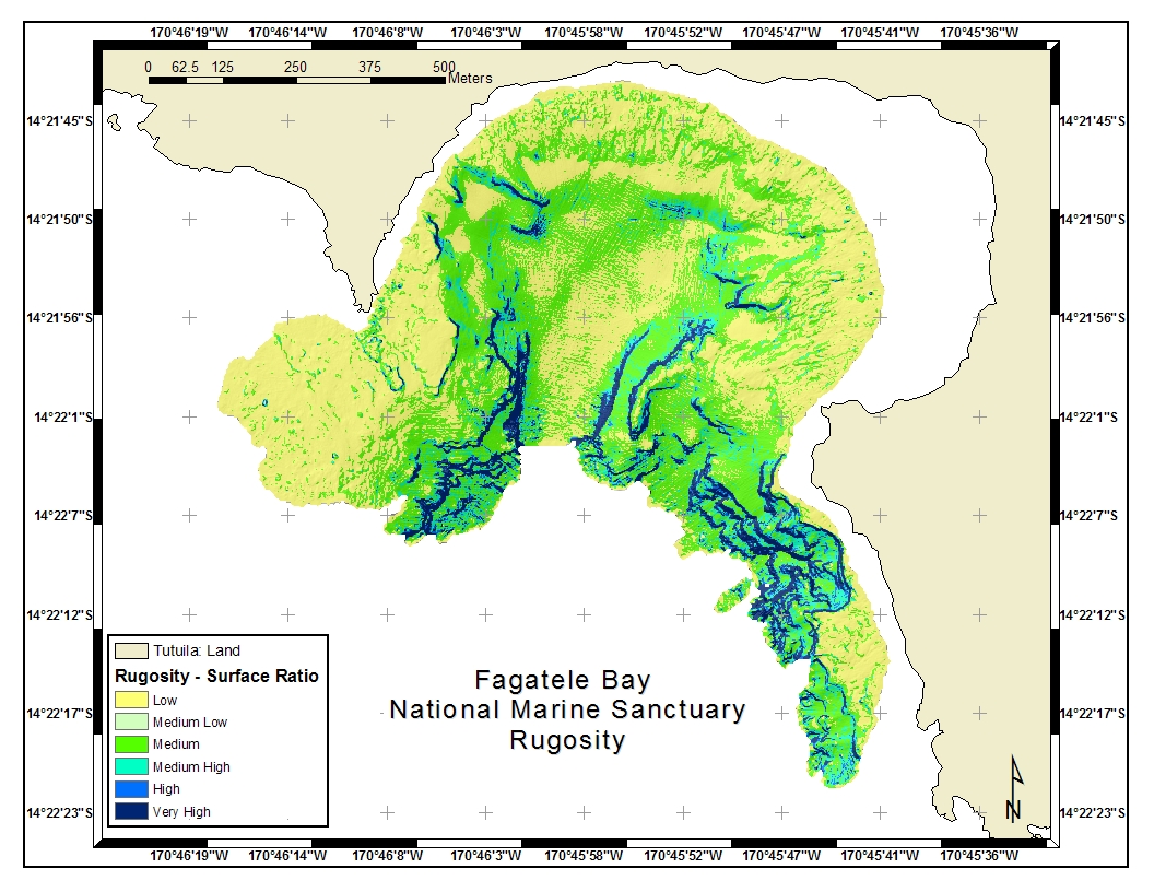
Email for FBNMS Rugosity, BPI Zone/Structure, Slope, Aspect grids
|
|
Fagatele Bay Bathymetry, Lat/Long 1-m grid
|
fb_sml.gif
|
fbnms1m_new.htm
|
fbnms1m_new.zip
(957 K)
|
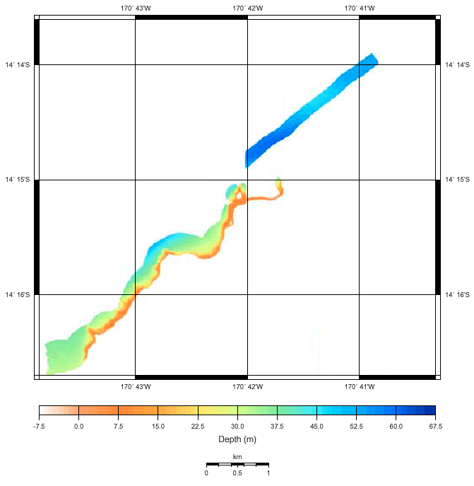
HURL 2005 Cruise
N. Tutuila Deep Bathy, Lat/Long
|
thumbnail and
location of survey
|
placeholder metadata
|
in progress
|
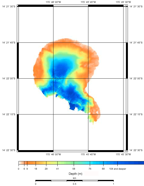
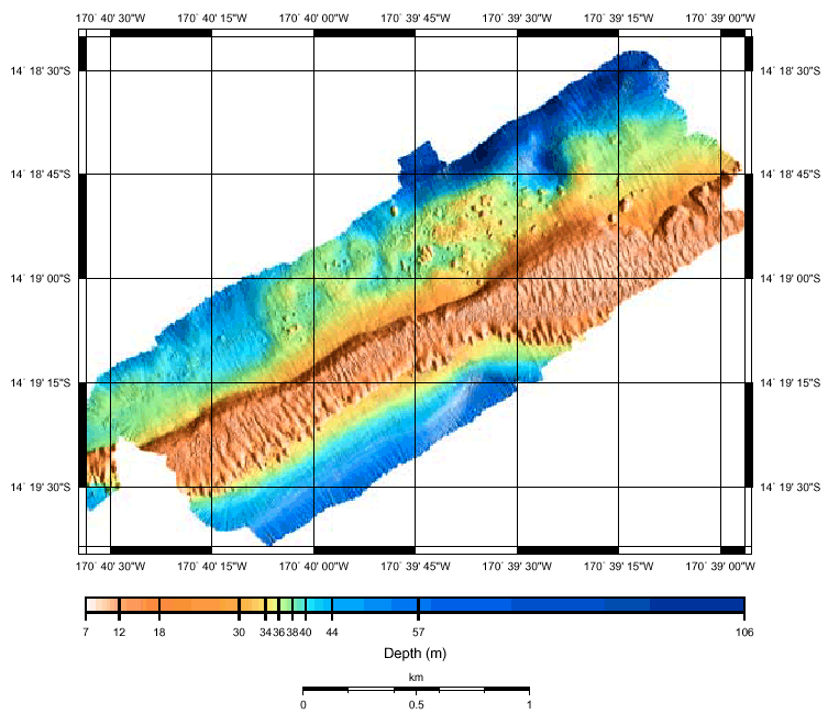
National Park Bathymetry, Lat/Long 2-m grid
|
natpark.gif
|
natpark2m.htm
|
natpark2m.zip
(1.3 Mb)
|
National Park
BPI Zones Grid
(for benthic habitat) |
See Maps below
|
metadata
|
ArcGIS grid
(Rt click-Save As)
|
|
Pago Pago Harbor Bathymetry, Lat/Long 5-m grid
|
pago_sml.gif
|
pago5m_new.htm
|
pago5m_new.zip
(181 K)
|
|
Pago Pago Harbor Shipwreck Bathymetry, Lat/Long 1-m grid
|
wreck_sml.gif
(potentially dangerous site - pls contact authorities if interested in
diving)
|
wreck1m_new.htm
|
wreck1m_new.zip (44 K)
|
R/V Revelle 2002 Cruise (Drift Leg 10)
Tutuila Regional Bathy Lat/Long
|
revelle.gif
|
revelle.htm
additional metadata
|
revelle_arcmap.zip
(256 K)
|
|
Samoa Regional Bathymetry, Smith & Sandwell, Lat/Long 1-km grid
|
samoa_sml.gif
|
samoa_bathy.htm
|
samoa_bathy.zip
(2.4 Mb)
|
|
Taema Bank (East) Bathymetry, UTM, 1-m grid |
figure |
metadata
|
ArcGIS grid
(Rt click-Save As)
|
|
Taema Bank (East) Bathymetry, UTM, 3-m grid |
figure |
metadata
|
ArcGIS grid
(Rt click-Save As)
|
|
Taema Bank (Western) Bathymetry, UTM, 1-m grid |
figure |
metadata
|
ArcGIS grid
(Rt click-Save As)
|
|
Taema Bank (Western) Bathymetry, UTM, 3-m grid |
figure |
metadata
|
ArcGIS grid
(Rt click-Save As)
|
|
Email for Taema Rugosity, BPI Zone/Structure, Slope, Aspect grids
|
Taema Bank Bathymetry (West), Lat/Long 1-m grid
|
taema.gif
|
taema1m.htm
|
taema1m.zip
(1.8 Mb)
|
Transit Bathymetry, Lat/Long 10-m grid
|
transits.gif
|
transit.htm
|
transit10m.zip
(883 Mb)
|
| Vatia Bay Bathymetry, Lat/Long 2-m grid |
vatia.jpg
|
metadata |
vatia2m.zip
(200 Kb)
|
|
TOPOGRAPHIC GRIDS |
|
Manu'a 1:24,000 (30-m) DEM, UTM
|
NA
|
inc. in zip
|
man_dem.zip
(4.4 Mb)
|
|
Manu'a Slope Grid, UTM
|
NA
|
inc. in zip
|
man_slope.zip
|
|
Tutuila 1:24,000 (30-m) DEM, UTM
|
tut_sml.gif
|
inc. in zip
|
tut_dem.zip
(8.1 Mb)
|
|
Tutuila 10-m DEM, Lat/Long Decimal Degrees
|
tut_sml.gif
|
tutuila_geo.htm
|
tutuila_geo.zip
(1.6 Mb)
|
|
Tutuila 10-m DEM, UTM
|
tut_sml.gif
|
tutuila_dem.htm
|
tutuila_dem.zip
(1.6 Mb)
|
|
Tutuila Slope Grid DEM, UTM
|
NA
|
inc.in zip
|
tut_slope.zip
|
|
Tutuila 1000 x 1000 ft Topo Shapefile, UTM
|
NA
|
Projection Help
|
Tutuilagrid1000x1000.zip
(100 Kb)
|
|
Tutuila 4000 x 3000 ft Topo Shapefile, UTM
|
NA
|
Projection Help
|
Tutuilagrid4000x3000.z
ip
(16 Kb)
|
|
Tutuila 8000 x 6000 ft Topo >Shapefile, UTM
|
NA
|
Projection Help
|
Tutuilagrid8000x6000.z
ip
(8 Kb)
|
|
VECTOR (Point, Line, Polygon) GIS LAYERS |
|
Projection procedures that may be needed (588 K pdf) |
|
DATA SET |
THUMBNAIL GRAPHIC |
FGDC METADATA |
DOWNLOAD FILE |
Benchmarks, Nat. Geodetic Survey (NGS)
(ArcView shapefile in UTM Zone 2 South NAD 83)
See also
National Geodetics Survey Web Site
|
NA |
NA |
Benchmarks.zip
|
|
Birkeland Reef Observation Points
|
pts_sml.gif
|
birkptpt.htm
|
birkpt.zip
|
|
Birkeland Reef Transects
|
trans_sml.gif
|
transectsl.htm
|
transects.zip
|
Tutuila Census Stats
(1960-2000)
|
NA |
inc. in zip |
tut_census.zip
|
|
Boundaries |
AS Coastal Mgmt Zone, Manua
(UTM Zone 2 South NAD 83)
|
NA |
inc. in zip |
man_ASCMP.zip
|
AS Coastal Mgmt Zone, Tutuila
(UTM Zone 2 South NAD 83)
|
NA |
inc. in zip |
tut_ASCMP.zip
|
|
AS Counties & Villages
|
NA |
inc. in zip
(error in Tutuila villages) |
AS_CountiesVillages.zip
|
|
Special Mgmt Area, Malaeimi Valley
|
NA |
inc. in zip |
tut_malaeimi_sma.zip
|
|
Tutuila Villages
|
NA |
inc. in zip |
tut_villages.zip
|
|
Coastlines/Shoreline (Ikonos-based) |
|
AS Coastline, UTM
|
NA |
inc. in zip |
AS_coast02utm.zip
|
|
AS Coastline, Lat/Long
|
NA |
inc. in zip |
AS_coast02dd.zip
|
|
Tutuila Coastline, UTM
|
NA |
inc. in zip |
tut_coast02utm.zip
|
|
Tutuila Coastline, UTM, Polyline
|
NA |
inc. in zip |
tut_coast02-lineutm.zip
|
|
Tutuila Coastline, Lat/Long
|
NA |
inc. in zip |
tut__anu_coast02dd.zip
|
|
Aunu'u Coastline, UTM
|
NA |
inc. in zip |
aun_coast02utm.zip
|
|
Manu'a Coastline, UTM & Lat/Long
|
NA |
inc. in zip |
man_coast02utm.zip
man_coast02dd.zip
|
|
Ofu/Olosega Coastlines, UTM
|
NA |
inc. in zip |
ofu_coast02utm.zip
olo_coast02utm.zip
|
|
Ofu/Olosega Coastlines, UTM, PolyLine
|
NA |
inc. in zip |
ofu_coast02-lineutm.zip
olo_coast02-lineutm.zip
|
|
Ofu/Olosega Coastlines, Lat/Long
|
NA |
inc. in zip |
ofu_coast02dd.zip
olo_coast02dd.zip
|
|
Ta'u Coastlines, UTM & Lat/Long
|
NA |
inc. in zip |
tau_coast02utm.zip
tau_coast02-lineutm.zip
tau_coast02dd.zip
|
|
Rose Coastlines, UTM & Lat/Long
|
NA |
inc. in zip |
ros_coast02utm.zip
ros_coast02-lineutm.zip
ros_coast02dd.zip
|
|
Swains Coastlines, UTM & Lat/Long
|
NA |
inc. in zip |
swa_coast02utm.zip
swa_coast02-lineutm.zip
swa_coast02dd.zip
|
|
Geology |
|
Tutuila Soils, UTM
|
NA |
inc. in zip |
Tut_Soil.zip
|
|
Hydrography |
|
Freshwater Biology, Tutuila, UTM
|
NA |
inc. in zip |
tut_hydro_biol_utm.zip
|
Hydrography, USGS, Tutuila, UTM & Lat/Long
(USGS 1:24,000 DLG)
|
NA |
inc. in zip |
tut_hydro_USGSutm.zip
tut_hydro_USGSdd.zip
|
|
Streams, Tutuila, UTM & Lat/Long
|
NA |
inc. in zip |
tut_streamsutm.zip
tut_streamsdd.zip
|
|
Sub-Basins, Tutuila, UTM
|
NA
|
inc. in zip
|
tut_shedminor.zip
|
|
Watersheds, Manu'a, UTM
|
NA
|
inc. in zip
|
man_shedmajor.zip
|
|
Watersheds, Tutuila, UTM
|
NA
|
inc. in zip
|
tut_shedmajor.zip
|
|
Wetlands
|
NA |
inc. in zip |
wetlands_data.zip
|
|
Infrastructure |
|
Buildings, Tutuila, UTM & Lat/Long
|
NA
|
inc. in zip
|
tut_bld90utm.zip
tut_bld90dd.zip
|
|
Buildings, Aunu'u, Lat/Long
|
NA
|
inc. in zip
|
aun_bld90dd.zip
|
|
Buildings, Roads, Ta'u, UTM
|
NA
|
inc. in zip
|
tau_roads-building
s03.zip
|
|
Flood Insurance Rate Maps (FIRMs), Manua, Tau
|
NA
|
inc. in zip
|
manua_tau_FIRM.zip
|
|
Flood Insurance Rate Maps (FIRMs), Tutuila
|
NA
|
inc. in zip
|
flood_rate_maps.zip
|
Roads, Aunu'u, UTM
(GPSed by Kevin Cronk, ASG DOC)
|
NA
|
inc. in zip
|
aunuu_rds_nadutm.zip
|
|
Roads, Manu'a, UTM
|
NA
|
inc. in zip
|
Man_roads02.zip
|
Roads, Ofu, Olosega, UTM
(GPSed by Kevin Cronk, ASG DOC)
|
NA
|
NA
|
ofu_olo_rds_nadutm.zip
|
|
Roads, Tutuila, east, UTM
|
NA
|
inc. in zip
|
tut_roads03_east.zip
|
|
Reefs |
Reefs, Samoa
(a more detailed layer from the National Park Service forthcoming)
|
NA
|
reefsl.htm
|
reefs.zip
|
Reefs, Ofu
(detailed
National Park Service shapefile from CAD drawing)
|
ofureef_sml.gif
|
ofu.xls
(MS Excel file)
|
ofu_nps.tar (Unix)
|
|
Regional |
|
Countries of the World, 2002, Lat/Long
|
NA
|
NA
|
cntry02.zip
|
|
Lat/Long Gridlines
|
NA
|
NA
|
geogrid.zip
|
|
Lat/Long Gridlines, 5 deg
|
NA
|
NA
|
Grid5Degree.zip
|
|
Topography |
Manu'a Contours, 10-, 20-, 50-m, 100-, 200-ft
UTM & Lat/Long
|
NA
|
inc. in zip
|
man_contour10mutm.zip
man_contour10mdd.zip
man_contour20mutm.zip
man_contour50mutm.zip
man_contour100ftutm.zip
man_contour200ftutm.zip
|
Tutuila Contours, 10-, 20-, 50-m, 100-, 200-ft
UTM & Lat/Long
|
NA
|
inc. in zip
|
tut_contour10mutm.zip
tut_contour10mdd.zip
tut_contour20mutm.zip
tut_contour50mutm.zip
tut_contour100ftutm.zip
tut_contour200ftutm.zip
|
|
Vegetation |
Vegetation, Tutuila, 1988
(thanks to Joe Donnegan USDA Forest Service)
|
NA
|
not yet
contact Joe
|
veg88map.zip
(zip of an e00)
|
|
DIGITAL RASTER GRAPHICS (DRG, georeferenced images) |
|
Projection procedures that may be needed (588 K pdf) |
|
DATA SET |
THUMBNAIL GRAPHIC |
FGDC METADATA |
DOWNLOAD FILES
(BOTH tif and trw are needed!) |
|
Ofu and Tau DRG, UTM Projection
|
NA
|
ofutau_drg.met.txt
|
ofutau_drg.tif
ofutau_drg.tfw
|
|
Tutuila DRG, UTM Projection
|
drg_sml.gif
|
tutuila_drg.met.txt
|
tut_drg.zip (32 Mb)
|
|
World Satellite Corp. Mosiac, Lat/Long
|
NA
|
NA
|
wsiearth.zip
(18.7 Mb)
|

GMT (Generic Mapping Tools) Grids
|
Get GMT |
|
DATA SET |
GRDINFO (Metadata) |
DOWNLOAD FILE |
E. Samoa Compilation, Subset (Cruise) 200-m grids, Lat/Long
|
N/A
|
zip file |
tar gzip
(both are 4.6 Mb)
|
Fagaitua Bay Bathymetry, 1-m grid, Lat/Long
|
grdinfo.txt
sample command file
|
fagaitua1m.grd
(8.9 Mb)
|
|
FBNMS Bathymetry, 1-m grid, Lat/Long
|
grdinfo.txt
sample command file
cpt file
|
fbnms_new1.grd
(13 Mb)
|
National Park Bathymetry, 2-m grid, Lat/Long
|
grdinfo.txt
sample command file
|
natpark2m.grd
(35 Mb)
|
|
Pago Pago Harbor Bathymetry, 5-m grid, Lat/Long
|
grdinfo.txt
sample command file
|
pago_new5.grd
(2.6 Mb)
|
|
Pago Pago Harbor Shipwreck Bathymetry, 1-m grid, Lat/Long
|
grdinfo.txt
sample command file
|
wreck_new1m.grd
(475 K)
|
|
Samoa Regional Bathymetry, Smith & Sandwell, 1-km grid, Lat/Long
|
grdinfo.txt
sample command file
|
samoa.grd
(673 K)
|
Taema Bank Bathymetry (West), 1-m grid, Lat/Long
|
grdinfo.txt
sample command file
|
taema1m.grd
(26 Mb)
|
Transit Bathymetry, 10-m grid, Lat/Long
|
grdinfo.txt
sample command file
|
transit10m.grd
(21 Mb)
|
3-D VISUALIZATIONS
|
iView3D Info
| Get iView3D for PC
| Get Beta iView3D for Mac OS X
|
|
DATA SET |
THUMBNAIL GRAPHIC |
DOWNLOAD sd FILE |
Coconut Pt. 1-m Bathy w/slope scalar
|
thumbnail
|
Zip file
*(includes GMT grid)
|
Coconut Pt. BPI Zones
|
thumbnail
|
Zip file
*(includes GMT grid)
|
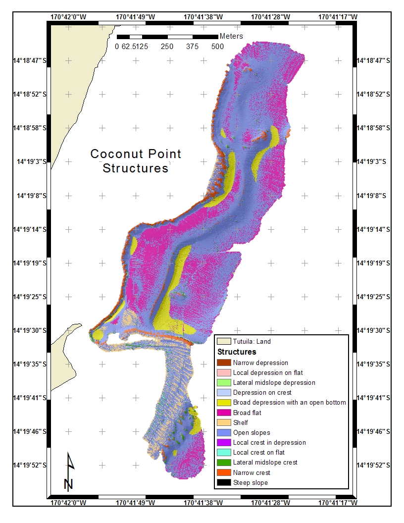
Coconut Pt. BPI Structures, scale 70
|
thumbnail
|
Zip file
*(includes GMT grid)
|
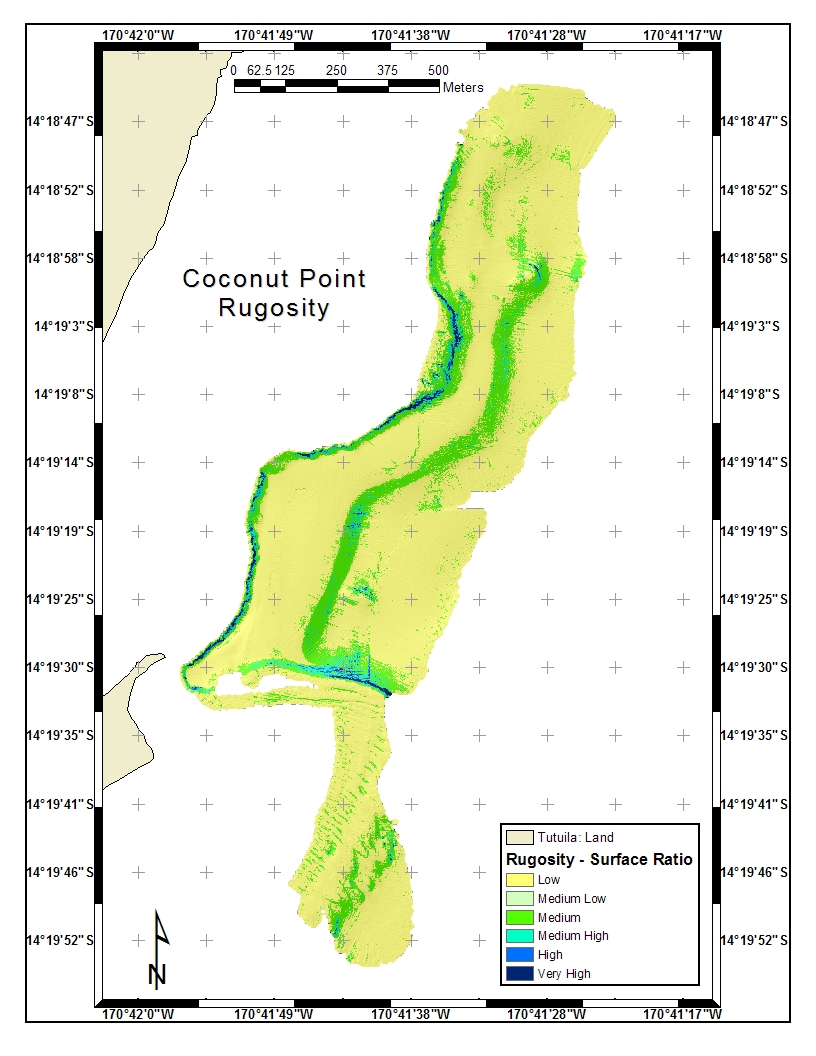
Coconut Pt. Rugosity
|
thumbnail
|
Zip file
*(includes GMT grid)
|
Color Map Files, Fledermaus
|
Rt Click, Save As ---->
|
bathy cmap
rugosity cmap
zones cmap
|
E. Samoa Compilation
|
thumbnail
|
.sd file (14.4 Mb)
shade (9.6 Mb)
scalar (4.8 Mb)
geo (186 Kb)
dtm (4.8 Mb)
|
Fagaitua Bay, 2001, ve=3x
|
fagaitua5m_2001.jpg
|
fagaitua_bay_5m.zip
|
FBNMS 1-m Bathy w/slope scalar
|
thumbnail
|
Zip file
*(includes GMT grid)
|
FBNMS BPI Zones
|
thumbnail
|
Zip file
*(includes GMT grid)
|
FBNMS BPI Structures, scale 250
|
thumbnail
|
Zip file
*(includes GMT grid)
|
FBNMS Rugosity
|
thumbnail
|
Zip file
*(includes GMT grid)
|
Fagaitua Bay, 2001, ve=3x
|
fagaitua5m_2001.jpg
|
fagaitua_bay_5m.zip
|
Pago Pago Harbor & S, 2001, ve=3x
|
pago5m_2001.jpg
|
pago_harbor_5m.zip
|
Revelle Cruise, Tutuila, 2002, ve=4x
|
revelle200m_2002.jpg
|
revelle200m.zip
|
Taema East 1-m Bathy w/slope scalar
|
thumbnail
| Zip file
*(includes GMT grid)
|
Taema East BPI Zones
|
thumbnail
|
Zip file
*(includes GMT grid)
|
Taema East BPI Structures, scale 250
|
thumbnail
|
Zip file
*(includes GMT grid)
|
Taema East Rugosity
|
thumbnail
|
Zip file
*(includes GMT grid)
|
Taema West 1-m Bathy w/slope scalar
|
taema5m_2001.jpg |
Zip file (Lat/Long)
Zip file (UTM)
*(includes GMT grid)
|
Taema West BPI Zones
|
thumbnail
|
Zip file
*(includes GMT grid)
|
Taema West BPI Structures, scale 250
|
thumbnail
|
Zip file
*(includes GMT grid)
|
Taema West Rugosity
|
thumbnail
|
Zip file
*(includes GMT grid)
|
|
Seafloor South of Samoa
|
S_of_Samoa.gif
|
Kings_3j.sd
|
Maps
|
GIF, JPG and PDF | Get Acrobat Reader |
|
MAP/IMAGE |
SOURCE |
DOWNLOAD FILE |
|
2001-'02 Bathymetric Coverage
|
Brian Donahue, Univ. of S. Florida
|
samoa_plan.gif
|
Coconut Point Rugosity Map
(for benthic habitat)
|
Emily Lundblad, OrSt
|
JPG image or
PDF
|
Coconut Point BPI Zones
(for benthic habitat)
|
Emily Lundblad, OrSt
|
JPG image or
PDF
|
Coconut Point BPI Structures
(for benthic habitat)
|
Emily Lundblad, OrSt
|
JPG image or
PDF
|
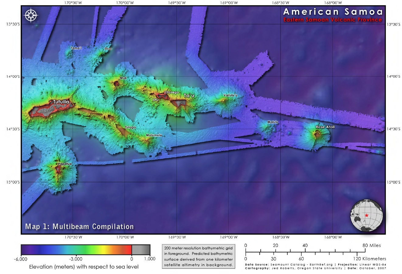
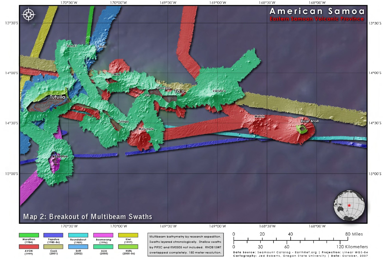
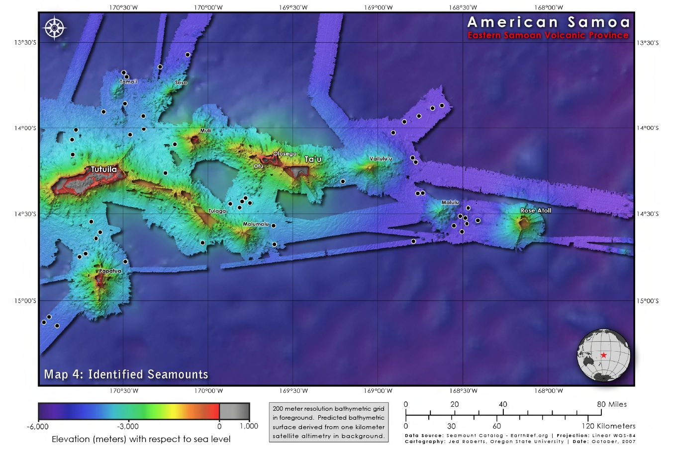
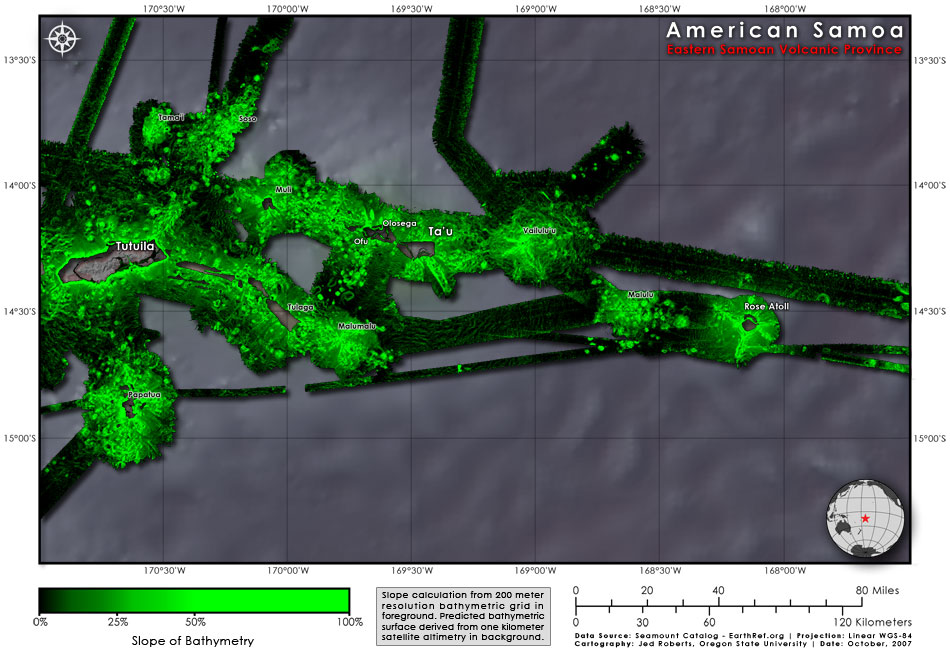
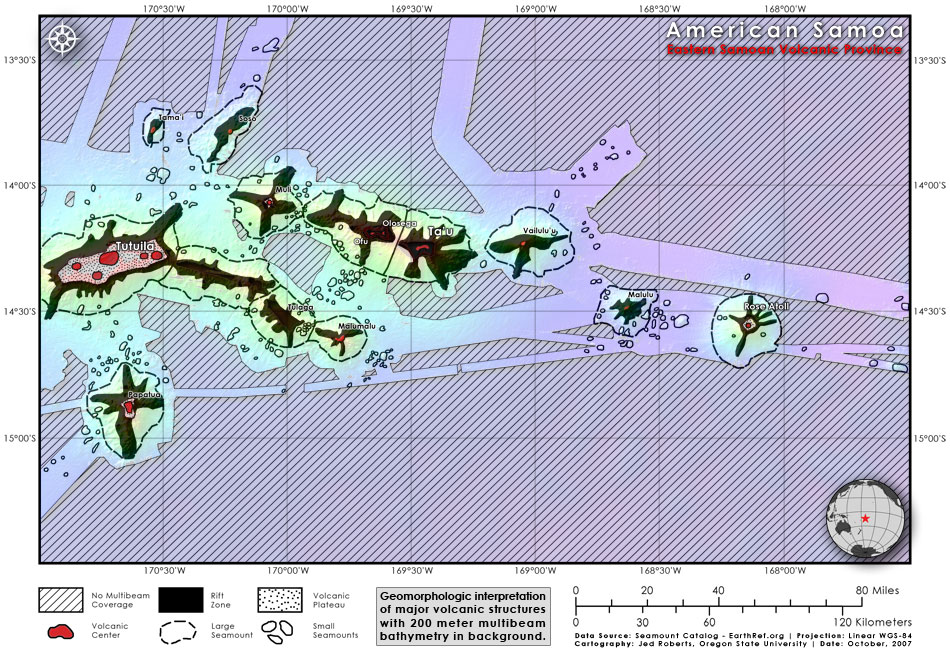
E. Samoa Compilation
(seamount shapes, distributions)
|
Jed Roberts, OrSt
|
study area JPG or
PDF
swaths JPG or
PDF
seamounts JPG or
PDF
slope map JPG or
PDF
geomorph JPG or
PDF
|
|
Fagaitua Bathymetry, 1-m grid
|
Dawn Wright, OrSt
|
fagaitua.gif
|
Fagaitua BPI Zones
(for benthic habitat)
|
Emily Larkin, OrSt
|
PDF
|
Fagaitua BPI Structures
(for benthic habitat)
|
Emily Larkin, OrSt
|
PDF
|
|
FBNMS Bathymetry, 1-m grid
|
Dawn Wright, OrSt
|
fbnms.gif
|
|
FBNMS Management Zones
|
Nancy Daschbach, FBNMS
|
zones.pdf
|
|
FBNMS Coral Reef Transects, 1985-1995
|
Charles Birkeland, Univ. of Hawaii
Green et al. (1999)
|
birkeland.pdf
|
FBNMS Rugosity Map
(for benthic habitat)
|
Emily Lundblad, OrSt
|
JPG image or
PDF
|
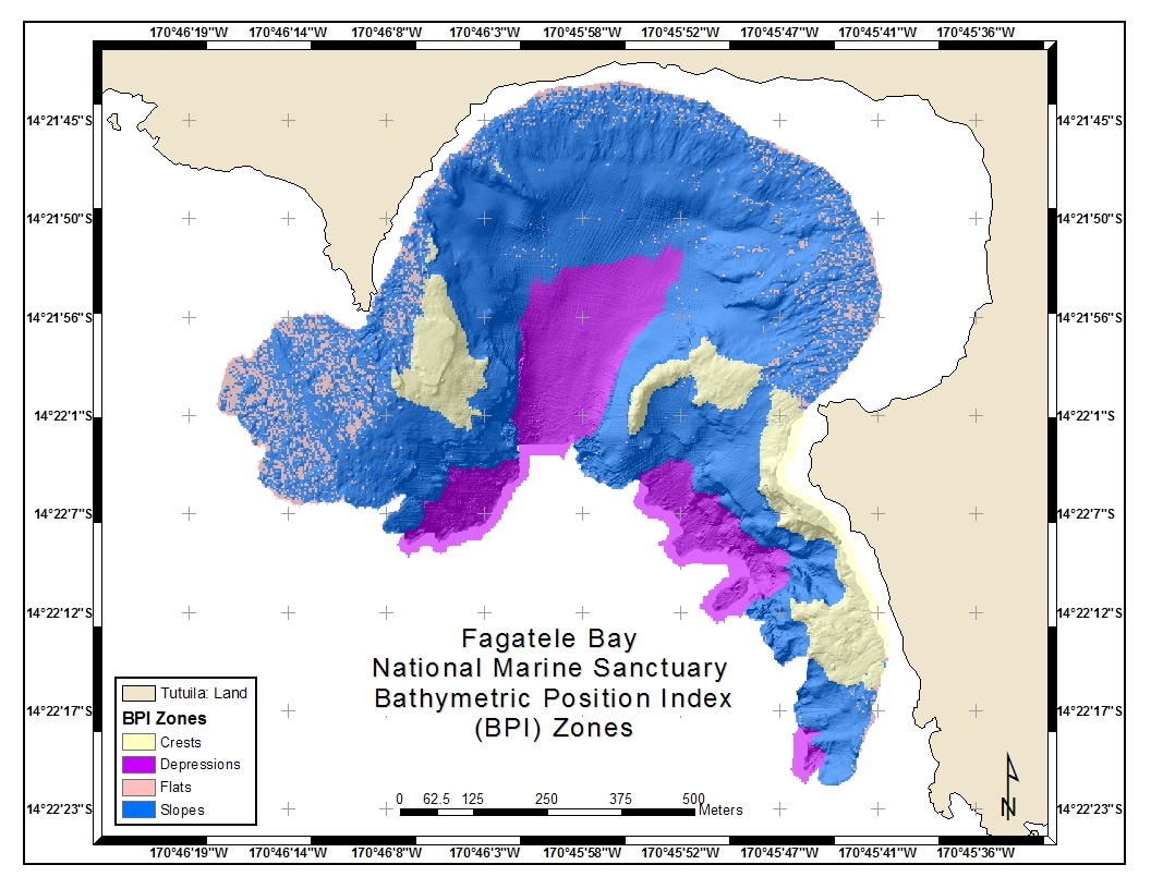
FBNMS BPI Zones
(for benthic habitat)
|
Emily Lundblad, OrSt
|
JPG image or
PDF
|
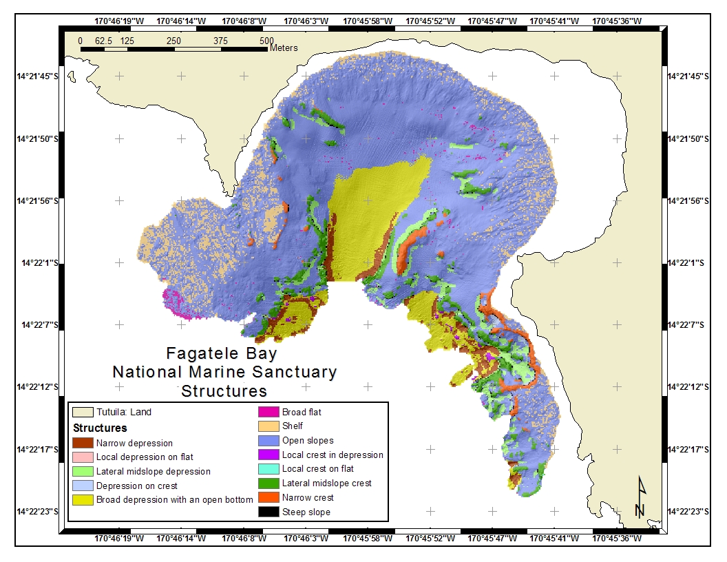
FBNMS BPI Structures
(for benthic habitat)
|
Emily Lundblad, OrSt
|
JPG image or
PDF
|
|
Islands of Independent and American Samoa, Map
|
National Park of American Samoa
|
islands.pdf
|
|
Islands of Independent and American Samoa, Pretty Graphic
|
Jayne Doucette, Woods Hole Oceanographic Institution's Currents Magazine
|
samoa_whoi.gif
|
|
Manua Islands, American Samoa
|
National Park of American Samoa
|
manua.pdf
|
|
Map Compilation, Multibeam Bathymetry, Samoa & Florida
|
Brian Donahue, Univ. of S. Florida
|
donahue.pdf
(1.6 Mb)
|
|
Map Compilation, Multibeam Bathymetry, GIS Screen Shots
|
Dawn Wright, OrSt
|
samoa_lib.pdf
(5 Mb)
|
|
National Park Bathymetry, 2-m grid
|
Dawn Wright, OrSt
|
natpark.gif
|
National Park BPI Zones
(for benthic habitat)
|
Emily Larkin, OrSt
|
PDF
|
National Park BPI Structures
(for benthic habitat)
|
Emily Larkin, OrSt
|
PDF
|
|
Ofu-Olosega Maps & Error Analyses, Bathy from Ikonos
|
Kyle Hogrefe, OrSt
|
zip of PDFs
(7.6 Mb)
|
|
Pago Pago Harbor Bathymetry, Shaded Relief, 1-m grid
|
Brian Donahue, Univ. of S. Florida
|
pago.gif
|
|
Pago Pago Harbor Shipwreck, Shaded Relief, 1-m grid
|
Brian Donahue, Univ. of S. Florida
|
wreck.gif
|
|
Regional Bathymetry, South Pacific
|
David Sandwell
Scripps Marine Geodesy
|
global_topo.pdf
|
|
Samoa and the World
|
Jeanne Harvey for the FBNMS
|
samoa_world.pdf
|
|
Samoa Index Map, Pacific
|
National Park of American Samoa
|
globe.pdf
|
|
Samoa Index Map, SW Pacific, Tectonic
|
Dawn Wright, OrSt
|
swpac.pdf
|
|
Samoa Regional Bathymetry
|
Dawn Wright, OrSt
(from Smith & Sandwell Bathy)
|
samoa.pdf
|
|
Seafloor South of Samoa, 3-D
|
Dawn Wright, OrSt
|
S_of_Samoa.gif
|
|
Taema Bank Bathymetry, Shaded Relief, 1-m grid
|
Dawn Wright, OrSt
|
taema.gif
|
Taema (East) Rugosity Map
(for benthic habitat)
|
Emily Lundblad, OrSt
|
JPG image or
PDF
|
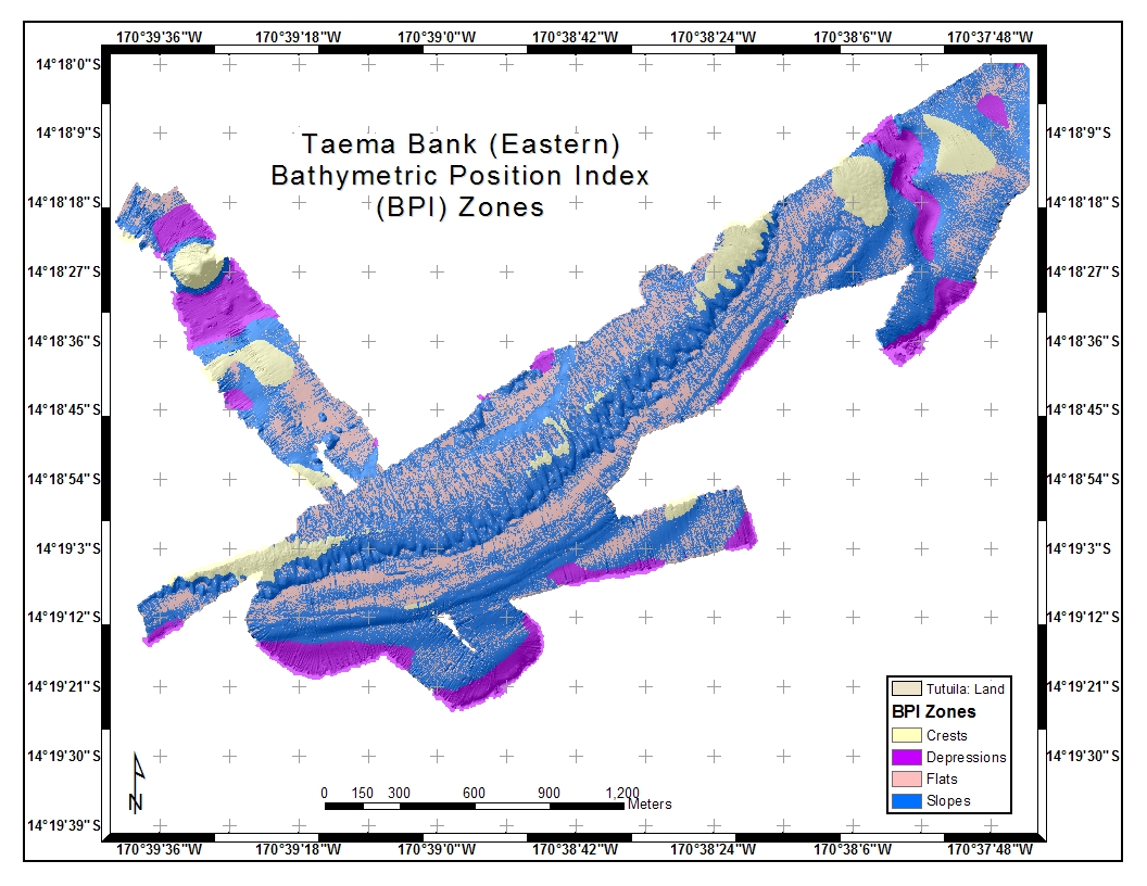
Taema (East) BPI Zones
(for benthic habitat)
|
Emily Lundblad, OrSt
|
JPG image or
PDF
|
Taema (East) BPI Structures
(for benthic habitat)
|
Emily Lundblad, OrSt
|
JPG image or
PDF
|
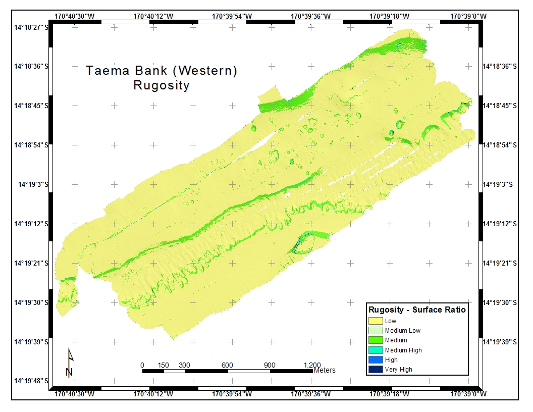
Taema (West) Rugosity Map
(for benthic habitat)
|
Emily Lundblad, OrSt
|
JPG image or
PDF
|
Taema (West) BPI Zones
(for benthic habitat)
|
Emily Lundblad, OrSt
|
JPG image or
PDF
|
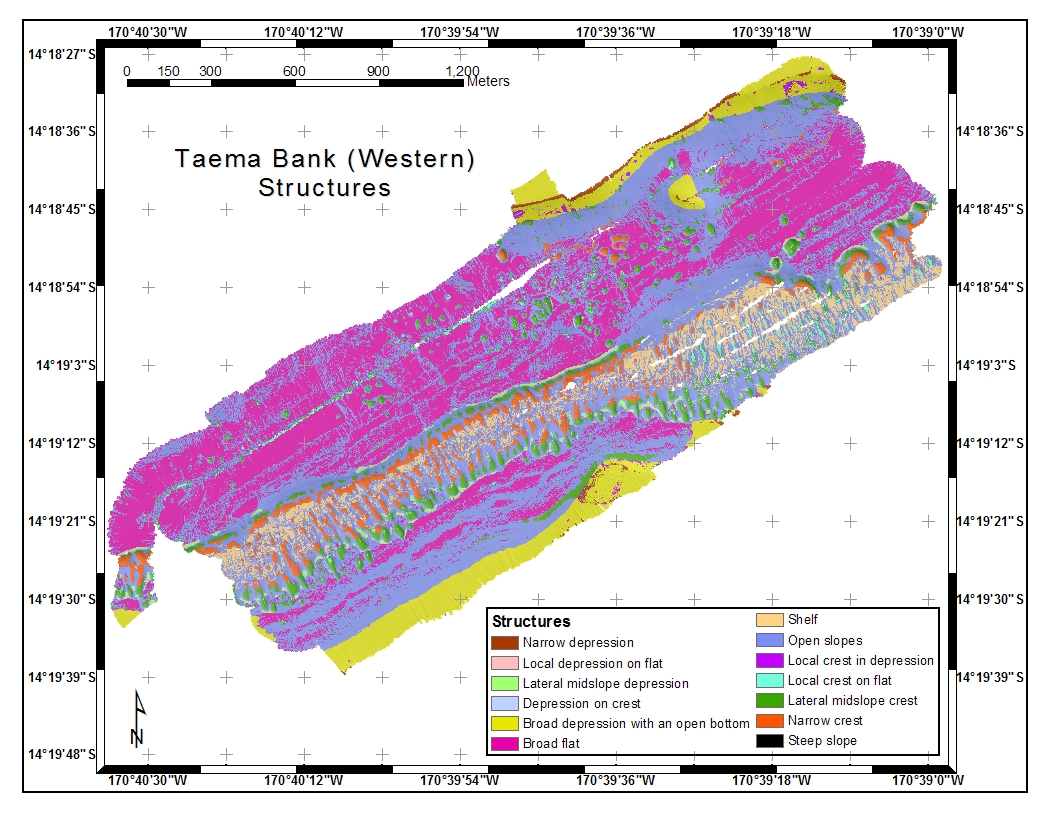
Taema (West) BPI Structures
(for benthic habitat)
|
Emily Lundblad, OrSt
|
JPG image or
PDF
|
|
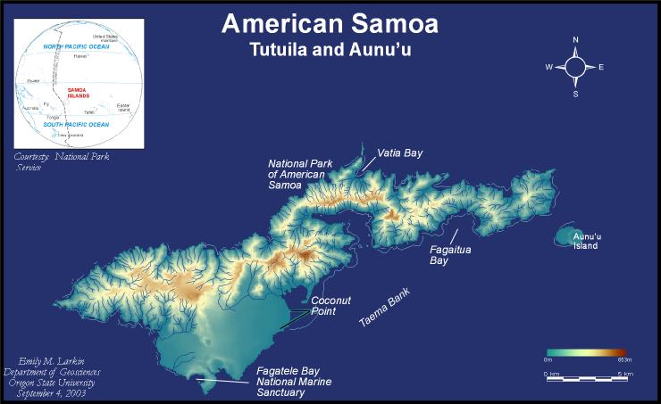
Tutuila and Aunu'u, American Samoa
|
Emily Larkin, OrSt
|
JPG image or
Large Poster
(14 Mb PDF, Rt Click-Save As)
|
|
Tutuila, American Samoa
|
National Park of American Samoa
|
tutuila.pdf
|
|
Tutuila
Coastal Terrain Models (CTMs)
|
Kyle Hogrefe, OrSt
|
Zip file of PDFs
(17.7 Mb, Rt Click-Save As)
|
|
Tonga Trench, south of Samoan Islands
|
Dawn Wright, OrSt
|
tonga.pdf
|
|

;)
;)
;)
;)
;)
;)
;)
;)
;)
;)
;)
;)
;)
;)
;)
;)
;)
;)
;)
;)
;)
;)
;)
;)
;)
;)
;)
;)
;)
;)
;)
;)
;)
;)
;)
;)
;)
;)
;)
;)
;)
;)
;)
;)
;)
;)
;)
;)
;)
;)